WINTER OUTLOOK 2023 IS NOW LIVE

The 2023 Winter Outlook

Monday, February 8, 2016

Monday Night Update: Final Forecast For Tomorrow's Winter Storm

Good evening, below is my final forecast for tomorrow. Here is a summary of impacts:


  • A moderate winter storm effects southern zones tomorrow morning into the evening
    • Hardest hit areas can see 3-6 inches
  • To the north impacts will be less over NNJ into southern New England
  • Snow should start to break late tonight/ early tomorrow morning in MD and Del and slowly work its way into the Philadelphia/Central NJ area by afternoon.
  • Snow will become most intense late morning into the afternoon for the hardest hit areas as an inverted trough of low pressure develops off the coast
  • Northern areas of NJ will see snow develop in the afternoon as this low pressure center drifts northeast off the coast
  • There is a chance this low pressure could track closer to the coast than expected causing more impacts to northern zones than projected
  • Snow ends for southern areas in the evening and northern areas just after midnight 

This storm will be a tricky little system due to the fact it involves something called an inverted trough of low pressure. Inverted troughs are notorious for throwing surprises thus making them very hard to predict. My map below is my best estimate of what impacts will be:


A breakdown of this storm can be found in the 2 min video below, enjoy!


Monday Morning Update: No Changes, Final Forecast Tonight

I am making no changes to the threat maps I put out yesterday. I will tweak them as necessary tonight when I put out a final forecast.

Here is the forecast from yesterday morning..


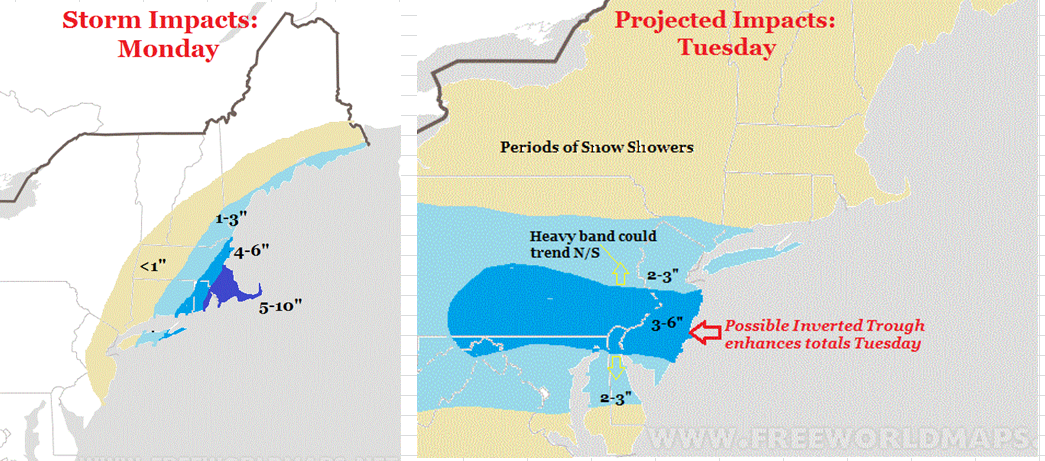
I feel pretty good about today's impacts on the left image. For tomorrow, determining where and how strong that inverted trough sets up is key. I can guarantee you that not everyone is going to be happy on Tuesday (those who like snow) but some should make out pretty decent. The key is where this inverted trough (dark blue zone) sets up. In this zone several inches of snow should fall tomorrow into tomorrow night. I still like the area I have from yesterday for the greatest impacts. Tonight I will try my best to hone in on this as much as possible. Expect some changes. 

More at 7pm. 

Sunday, February 7, 2016

Superbowl Sunday Storm Update: My Forecast

I have been doing a lot of talking over last few days about two storms that will impact the area. To Review:
  • Storm 1 brushes by area tonight, hits eastern New England with Snow
    • Several inches will fall up there
  • Storm 2 hits area Tuesday but will be more focused on a narrow area (more below)
    • Area that is in the narrow band can see 6+ inches due to something called an inverted trough developing

Here are my impact maps for Monday and Tuesday:


For Tuesday, this whole forecast depends on an inverted trough developing over the area. Without going into too much detail an inverted trough results in a narrow band of heavy precipitation possibly developing. I tried to indicate where I think that will occur as seen by the 3-6" zone Tuesday. Fair warning, this is very volatile and could shift north or south! Regardless, who ever gets into that heavier snow will see several inches fall.

My quick 2 min video below breaks down this forecast. I suggest you watch for easy to understand details. More on twitter today and blog update tomorrow morning..


Update and Maps out at 1130am

Saturday, February 6, 2016

Saturday Afternoon Storm Update: The Preliminary Forecast

*I have decided to postpone the threat map until tomorrow morning due to high model volatility*

<<<<<<<<<<<<<<<<<<<<<<

Well I think I have seen enough over the last few days in terms of figuring out what will happen early next week.  I am confident that storm 1 stays offshore and  brushes the NYC area with some snow. Up in eastern New England the impacts will be greater (several inches possible). That in itself is going to end up being the problem with Storm 2. I mentioned this week  if Storm 1 was too strong and close to the coast, it would steal energy away from storm 2. That looks like whats going to happen. What we will be left with is the chance for periods of snow on Tuesday as a digging trough tries to redevelop low pressure off the coast. Most areas in the Mid-Atlantic and northeast might see a few inches with the zone of heaviest snow to be determined. A phenomenon called an inverted trough might set up. Where this occurs will dictate where more significant snow amounts are. 

There is no question that this pattern stays active for the foreseeable future. Regardless of what happens early this week, we have another shot at a very large storm towards the end of next weekend. Cold air will be in great supply and I expect this pattern to linger around until 2nd week of march. If we get out of this period unscathed I would be very surprised. 

In Summary:


  • A very strong coastal storm brushes by the area Monday
  • This will give areas in eastern Long Island and New England accumulating snow and cause some snow to fly near coastal sections of NJ (inch or two)
    • Yes there is a chance this trends west more and hits whole area with significant snow. 
    • Not my base case, but we will have to keep a close eye on this
  • Due to the strength of this first storm, Storm 2 will have a hard time intensifying on Tuesday
  • Regardless, everyone should expect periods of snow on Tuesday with a few inches of accumulation possible
  • There is evidence a weather phenomenon called an Inverted Trough can develop on Tuesday and enhance snow amounts for certain areas.
    • If this does occur then those areas can see over 6 inches of snow
    • It is extremely hard to project where this will happen but I show below an area I am targeting.

So here we go. Storm 1 is a near miss for most areas Monday and hits eastern New England with snow. As you can see, this is a massive storm so the precipitation shield will hit most areas. You are looking at the NAM model below and I think it is a little overdone. The best bet for any notable snow is eastern New England. We will see if this trends more and they end up getting a significant storm. 


Notice all the precipitation to the west of this storm. That is the clipper system that will try to redevelop off the coast Tuesday and cause storm 2. This is seen below..


Notice there is a low pressure center shown by the GFS model off the coast and a lot of scattered precipitation around it. It is at this time that we might see that inverted trough develop. This would end up giving much heaver snow amounts to what ever area is in its cross hairs. On this next image valid 12 hours later, you can see the GFS trying to indicate this developing..


Now we are going to have to use higher resolution models as this event gets closer. The NAM model is one of those. You can see it is trying to show enhanced show developing Tuesday night into Wednesday due to this possible inverted trough shown below. 


If this does in fact occur, then some areas could see over 6 inches of snow Tuesday into Wednesday morning. 

If you cant tell already, this is extremely difficult to predict! I am confident though that flakes will fly Tuesday with the heavier amounts remaining to be seen.

Thanks for reading more tomorrow morning!

Preliminary Threat Map Out This Afternoon Around 4

Good morning. I am finally starting to get a general grasp on what I think will happen Monday and Tuesday. At this time it does it fact look like Storm 1 stays out to sea and Storm 2 will impact the region. This means scenario 2 mentioned in yesterday's post is gaining momentum. I will have a preliminary outlook out this afternoon around 4. My thoughts from last night are in my last post. Stay tuned!

Friday, February 5, 2016

Friday Night Storm Watch: Down To The Wire Again for Next Week

It seems as if every forecast so far this year has been a big challenge. The Blizzard of 2016 did not trend till literally a day before, the snow event this morning (dropped a foot in some spots) did not trend until a day before, and now we are faced with a very complicated setup for next week. Sometimes it may actually be easier to see the "threat" of a storm 2 weeks away (my case study) compared to trying to iron out the finer details 72 hours away as it approaches. Here is a summary of my latest thoughts:


  • We will have a shot at more winter weather early next week (Mon-Tues)
  • Two systems we need to focus on
    • System 1 is a big storm that is going to develop off the coast
    • System 2 is a clipper system that is going to dive down from Canada and potentially redevelop off the coast
  • System 1 will directly impact how system 2 forms
  • At this time signs point to system 1 staying offshore
    • However, there are a few models that make this the main system!
  • If system 1 blows up off the coast and just misses us, I think we miss out on major effect from system 2 due to the atmosphere being robbed of energy. 
  • If I had to make an estimate I would say system 1 does stay offshore allowing system 2 to form over area.
    • It is too early for me to give exact impacts
  • If this happens the area sees snow Tuesday

So here we go...

System 1...

Image above is from the NAM model, which is most aggressive with this storm. Could the NAM be onto something? Maybe, but I do not buy the idea yet of storm 1 having a major impact on the area. 


GFS is less aggressive..


Even though I do not think this ends up happening,the image below shows how storm 1 can really become a monster for the east coast..


What you are looking at above is two main areas, storm 1 and an upper level trough digging down from Canada. IF this trough digs enough and storm 1 is slowed down by block over eastern Canada, then the digging upper level low would help steer storm 1 back to the coast. Like I said, I do not support this extreme scenario at this time but we need to watch trends on this!

Back to my base case. I think storm 1 does exit off the coast like the GFS says. In its wake, a new low pressure center should redevelop on Tuesday over the area..


Looking above you can see the GFS model trying to project this. I am not trying to speculate on the intensity on this second system given the fact we are trying to track two storms at once! If I really had to some this up I think we have three scenarios. 

Scenario 1 (worst case): Storm 1 trends closer to coast and whole area sees very signifigant storm

Scenario 2 (base case): Storm 1 stays offshore enough to allow storm 2 to form off the NJ coast. This would give the area a shot at some decent accumulating snow. Impacts could be major but too early to speculate. 

Scenario 3 (no storm): Storm 1 is a near miss and does not allow storm 2 to form strong enough resulting in only snow showers for the area. 

So thats the only details I can give at this time. This forecast is extremely complicated due to the fact we literally have to track two storms at once. You guys will see frequent updates daily as this situation evolves. Hopefully by tomorrow I can nail this down more.

In any event this pattern is loaded! More storms and rumors of storms to come following this initial threat. 

More tomorrow AM.