WINTER OUTLOOK 2023 IS NOW LIVE

The 2023 Winter Outlook

Monday, June 8, 2015

Monday Morning Weather Summary

Good morning, I hope everyone had a good weekend. Things will return back to warmer conditions this week.  Temps will be in the low 80's to start the week and rise into the mid to high 80's as the week progresses. There will be times with humid conditions as well which does not make for comfortable weather. 

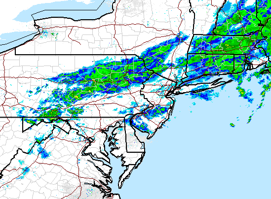
The week will not start off particularly well as yet another front moves through our area tonight and tomorrow. I am seeing high moisture values ahead of this front so expect periods of heavy showers and some storms tonight through tomorrow.


Front clears by end of the day Tuesday and high pressure builds into the area for Wednesday and Thursday. High pressure means nice conditions with temperatures in the mid to high 80's.

The next shot at unsettled weather comes as we head into Saturday with more showers and storms possible..


I do expect sun to come out on Saturday however so it will not be a "rainy day" Just a warm humid day with a chance at approaching storms. Sunday should be mostly sunny skis.

I will note we are now officially in hurricane season. However, given the El Nino I do not expect a very active season along the east coast. I almost have my El Nino post ready to go so that will be out on Wednesday night of this week. I'm no expert, but my goal is to give everyone a general idea of what El Nino is and how it effects our weather. 

Thanks for checking in. 

Friday, June 5, 2015

Quick Weekend Weather Update: Don't Be Fooled by Clouds Today..Nice Weekend Ahead

Good afternoon everyone. Although there were some spots of rain today and that may continue though tonight as a cold front moves through, the weekend looks excellent. As we head into tomorrow the front clears the area and any clouds should quickly dissipate. You can see the front exiting tomorrow morning below..


High temps in the mid 70's for Saturday.

Looking at Sunday a nice area of high pressure builds into the region with sunny skies and temps in the low to mid 70's


That's all for today, thanks for checking in.

Tuesday, June 2, 2015

Tuesday Morning Weekly Summary: Front Finally Leaving Area, Calm Weather to Follow

Good morning. The rain totals ended up living up to the hype. Many areas saw several inches of rain though this morning as this front slowly moved through the area. If we currently look at the surface map, we can see that the front has finally drifted south with very cool temperatures behind it (red numbers)..


There are still lingering showers however and these will last through early this afternoon..


We then get high pressure to build back in for Wednesday and Thursday (seen below) which will result in calm and cooler conditions. Expect highs in the upper 60's and lower 70's through Friday. 


Our next shot at showers is Friday as another cold front moves through the area..


At this time I do not expect a big rain event. This will just be a few passing showers at some point Friday into Saturday. 

The weekend overall looks pretty good. Once the front fully passes on Saturday we should have more calm and cooler conditions with temperatures in the low 70's.

I will update again as we close in on the weekend.  Also, I will definitely have the special post breaking down "El Nino" by the weekend as well. 

Friday, May 29, 2015

Friday Weekend Weather Update: Make Your Plans for Tomorrow, Sunday Looks Wet

Good afternoon. I hope everyone had a good week and are looking forward to relaxing this weekend. This weekend will feature a mixed bag of weather. We have a nice summer like day tomorrow (Saturday) then things will go downhill from there as a low pressure system develops along a front and stalls. This means yes rain for Sunday and possibly though Monday! Models differ a little on how this evolves but lets take a look.

High pressure remains in control offshore tomorrow promoting the nice weather overall. There could be a few pop up thunderstorms but I am not too concerned at this point..


Notice however that low pressure system over the Mississippi Valley. That is what is going to sweep its cold front into our area Sunday...


Looking above you can see the showers and storms moving into the area for Sunday as that front establishes itself.  This lingers though Monday..


What you are now seeing above is a stationary front (the stalled cold front from Sunday) with a low pressure center developing along it on Monday. This would extend the rain and possibly pile up some impressive totals. We will have to see if this extension of the rain really ends up being a big deal. As I said before not all models are on board with the impressive rainfall totals. 

To put a little more prescriptive on this. I included below a view of the jet stream. You can see the trough or dip in the jet stream over our area for Sunday and Monday..


The red lines represent the flow of the air. We will have a moist southeast flow from the Gulf which will help enhance the rain totals along that stationary front.

In any event, not the greatest end to the weekend in store but we salvage one day which is better than nothing. 

I know I said I had an El Nino post coming and I do! It was a crazy week at work and I will hopefully be able to get it out sometime this week. Stay tuned and enjoy the weekend!

Tuesday, May 26, 2015

Tuesday Weekly Weather Summary: A Summer Week Ahead With Some Storms

Good morning everybody. I hope everyone had an enjoyable Memorial Day weekend and had some time to relax. It was a perfect transition into kicking off summer this weekend as temps have been gradually increasing and will stay elevated all week. 

A large ridge of high pressure is currently over our area bringing with it warm and now humid conditions. This air mass will be responsible for temps in the 80's all week. It will probably hit 90 in spots as well over the next two days. As this warm and humid air mass sits over our area we have to focus on a cold front that will approach the region tomorrow night..

Anytime we see a low pressure system up in southern Canada (in this case just north of the lakes) during the summer months we know that its cold front is on its way. When you have cooler air running into a warm moist air mass you have the potential for storms to develop. Its not always as simple as that of course. You also need the proper "instability" in the atmosphere to fire up the storms. For example, if you have a elevated layer of warm air above the surface it can prevent air parcels from rising thus cutting off the development of storms. 

In the case of tomorrow, it looks like the environment will be ripe for some storm development. I do not expect very strong storms however. Below is the instability profile for Wednesday..

Without getting too technical these are values for the "lifted index" which is the temp difference between an air parcel and its surrounding environment. The image above shows that there will be some lift or instability but not anything in the severe category. 

To drill down further here is a high resolution model's projection of the storm line for tomorrow eve/night..

Lets see how this plays out.

After we get though tomorrow, the cold front will stall off shore and we will have more shots at some unsettled weather heading towards the weekend. I will update on the weekend of course as we approach.

Don't forget, sometime this week (when time permits) I am going to do a special post on El Nino and how it effects our weather pattern. This is due to an El Nino pattern that is currently developing.

Stay tuned!

Friday, May 22, 2015

Friday Weather Update: Memorial Day Weekend Still Looking Stellar

Good afternoon everybody. I hope everybody is winding down their work week and looking forward to this long holiday weekend. Today is a perfect representation of how the rest of the weekend will go. Mostly sunny skies with temperatures generally in the low 70's. Sure its not summer weather but i'll take it. 

So lets take a look day by day. If we study the current pattern of the jet stream you can see we have a trough or a vortex sitting over southeast Canada. This is causing the cooler weather and also those cold night time lows we have been seeing over the last few nights. In fact we could have more frost in northwestern counties as we head into tonight!


This vortex lingers through tomorrow holding temps in the mid 60's to the north and high 60's to the south for Saturday.

As we head into Sunday a ridge or "rise" in the jet stream starts to come into our region. This will cause temps to gradually warm..


The red colors above represent this ridge. Notice that blue vortex has now really retreated to the north. The result will be temps in the low to mid 70's on Sunday then mid to high 70's once we hit Memorial Day. 

This pattern then looks to lock in for the rest of next week and possibly into June. This would mean warmer than normal temps to end off the month. Summer is here guys and it isn't going anywhere for a while. I notice a good follower of mine "Jim" referenced the lack of rainfall this spring and he is correct. It really has been pretty dry hence boring weather wise. 

I expect this trend to stay the same as we enter an "el nino" summer. If any of you have been following the headlines you might have heard mention of El Nino. I will dedicate a post to El Nino next week, what it is, and its impacts on our weather pattern. Stay tuned!

Enjoy the weekend guys!

Tuesday, May 19, 2015

Tuesday Morning: Taking a Look at Today's Storm Threat

Good morning. As I mentioned yesterday, we have the shot at some storms later this afternoon as a cold front approaches from our west. At this time I do not expect a large storm breakout but there will definatly be areas that get effected later today with some strong storms. 

Here is the simulated radar for this afternoon..


Notice the pockets of storms extending up into New England. I would assign a 40-50% chance that any one location gets effected. These storms will form from lifting due to an approaching cold front from the west..


Following the passage of this front, the weather will be very tame heading into the weekend. I can guarantee you that this Memorial Day weekend with not be a scorcher. If anything, it will be a little chilly on the beach with temps in the low 70's but with plenty of Sunshine. 

I will have another update on the weekend later this week. 

Thanks for checking in.