Good morning. This post is a follow up to my last post that discussed the potential pattern change late month into February. This would follow the current mild spell we are going to see over at least the next 10 days. Nothing has really changed from what I discussed on Friday so I figured I would share some updated model projections.
But first, a nice mountain snowstorm hits New England today with rain to the south..
Several inches of snow possible at the high elevations with this system.
As we head into the middle to end of this week the warm air builds in..
Remember warm for this time of year does not mean 65, that would be a blow torch. This is more of a mild pattern with temperatures in the high 40's and low 50's.
We have the potential for a big driving rain storm early next week...
Then the question becomes what will follow. All the data still supports a turnaround. Lets look at the models valid end of next week.
European Ensemble..
GFS Ensemble..
Canadian Ensemble..
Notice by late next week they are all showing pressures (red) build out to the west. With a key trough south of the Aleutian Islands and lower pressures (blue) in the east. This pattern is projected to possibly lock in for February. If that happens then February is a wintery month.
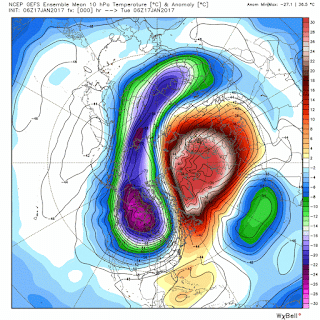
We also still have support from the stratosphere which is currently warming and could turn into a sudden warming event...
This is current state way up in the stratosphere. Notice the warming taking place. This is projected to continue and put stress on the polar vortex. This would increase the chances for cold air to filter into the country as February gets underway. This is never a factor to overlook.
So as the title of my post says we are waiting and seeing. The models and their projected atmospheric factors look great but remember they are still PROJECTIONS. We need to now see where the rubber hits the road. If it does, then we could be having a lot of fun this February.
I will discuss this all over a video sometime this week.


Hi Willy, Thought-provoking analysis, as always. As usual, I'll take a shot at offering a "but..." or two, with the usual caveat that I ain't got no PhD in weather science so get out the grains of salt. First, I agree that there's a significant warming going on in the polar stratosphere right now, and despite some discussion about a lower degree of "coupling" this season between the strato and troposphere, I'm gonna guess that something's gotta happen down below after such a big temp spike up above. And sure enough, the models show the northern jet getting down into our neighborhood around the end of the month. But they don't seem to anticipate much NAO blocking support, so you don't get that huge bowl over the east filled with arctic air all the way to Atlanta. Your Pacific dynamics look just that, quite dynamic. There don't appear to be any perma-features such as back in the days of the GofAlaska "blob" (La Nina turned into a "La Nada", according to Tom Yulsman's blog about whether global temp trends are affecting the ENSO). There are gonna be Aleutian troughs, but they still appear to be fairly zonal, they eventually just "move along", in my quick look. The MJO appears to wake up and get into zone 1 for awhile this month, but seems to be back in the quiet zone by the end of the month. The telecon forecasts (NAO, AO, PNA, EPO, WPO) into early Feb look like a mixed bag. So I don't think you can count on the NAO right now to support a big fixed eastern trough -- looks like both warmer and colder water patches near Greenland, nothing decisive. The arctic stratosphere is where the action is right now, or so I'm gonna guess; and thus we might look forward to some cold shots in February. That should end this January thaw that supposedly will go on for another 10 days or so. If so, then the first half of the winter season was mostly blah, a bit of this, a bit of that. The second half is in play, could be some real winter action before its through. But I don't see any "locks" in sight at the moment. Your "wait and see" prescription is about the best advice right now. Funny though, but we've been waiting for this winter to show its true character since October, and now in mid-January we're still waiting! Jim G
ReplyDeleteI agree 100% with everything you just said. Lets just see how it plays out. I like what I see but at same time will not be surprised if it is more of the same. Like you said we have been waiting since October. The overall "feel" isn't there right now. Lets leave it up to mother nature to surprise us.
DeleteHey Willy, how do you like that GFS Parallel, which I believe is supposed to become the main GFS in a few months? It's supposed to be new and improved, I hear. It definitely gives different outputs at 300+ hours. Up to the Euro? Probably too soon to tell, but any better? Jim G
Delete