To start off here where initial model projections for Sunday before the stronger trend started..
Now here is the updated projection for Sunday night. Notice more focused area of low pressure near the lakes. This will put down a few inches of snow for Michigan and some areas just to the east.
As we get to Sunday afternoon, we can see snow up in VT,NH and flurries in other areas..
Here is the accumulation map through Monday..
Looking below notice that area of rain off the coast. That is additional energy and there is a chance it can interact with the backside of the trough from the first system Monday seen below with low pressure off shore..
It appears most of this second wave stays off shore and does not develop into another storm on Monday. That can change but at this time I do not support that. In any event all of this ushers in very cold air this weekend and early next week..
By Monday highs will be only in low 40's and lows at night below freezing in many spots. Below is 1pm Monday..
It means that starting this weekend we will see swings in our weather pattern from mild to cold vice versa through the end of the month. In fact, we might even see temps moderate a little as we get to end of next week just to see them get cold again by the following week.
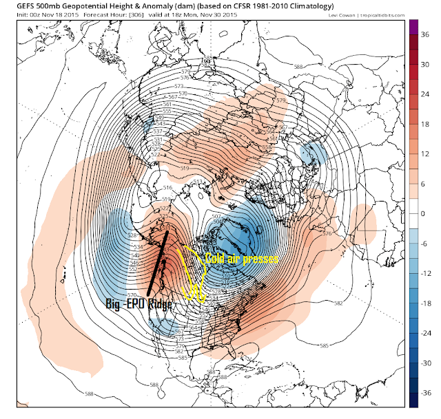
Below shows long term model projections and I want you to focus on one thing the big ridge over Alaska just off the west coast.
Anytime I see that I know the central to eastern part of the US is facing the threat of colder than normal conditions. That red or ridging you see of the east coast does not concern me. In the end I believe we will have more cold days than warm from a pattern like this due to that -EPO.
In the end this whole process of our seasonal pattern change will take a few weeks but like I said expect a lot of back and forth weather in the meantime. As always, we will keep an outlook for any storms that might be on the horizon. For now its this system on Sunday and the slim chance for more coastal interaction early next week.
Thanks for reading.


goedkoop nike air max schoenen , een combinatie van elegante stijl en geavanceerde technologie, een verscheidenheid aan stijlen van goedkoop roshe, de aanwijzer loopt tussen uw exclusieve smaakstijl.
ReplyDelete