Real quick before we get there, lets take a look at this week. This current cooler than normal air will last until about Wednesday. Expect temps in many areas to not get past the mid 50's with low 50's in many spots. Today will be the coldest day however w widespread 40s.
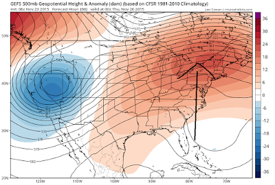
By the time we get to Wednesday and Thanksgiving day, warmer air will work its way in due to a rise in the jet stream seen below..
Remember the jet stream acts as a barrier between air, so the rise in the jet stream lets warm air from the south build into our area later this week. Expect temps to rise closer to 60 Thanksgiving day with mostly sunny skies!
Our next round of unsettled weather comes on Saturday as a cold front approaches. Don't expect much rain with this and if anything some areas in New England get snow showers. The key to this front is that it brings in fresh cold air for the weekend as seen by image below..
It is in the wake of this front that I see this weather pattern coming alive again and showing signs of how it will behave this winter.
Looking ahead into the week after Thanksgiving we will most likely see a jet stream configuration like this
We will hone in on this as the days go by this week. The point I am trying to make is the following: we have a lot of activity in this weather pattern. This is a theme that will continue this winter. No every storm will not effect us and it will not always be snow BUT there should be enough action to give us that shot at 30% more snow than normal like I forecasted.
Lets remember what I am expecting the overall jet stream to look like..
To make my point here is projected Jet Stream for next week's potential storm setup below..
Do you guys see what I am saying when I discuss this winter pattern "evolving". There was a method to come up with this forecast and now is a critical period to see how this unfolds. At the end of the day whether it be now or a little later in the season I think we will have a lot of action to talk about.
More tomorrow.


brad our weather man in charlotte, n.c. think's we may get at least 3-4 good snows in western piedmont
ReplyDeleteI can see that, especially by end of Jan into Feb.
Delete