WINTER OUTLOOK 2023 IS NOW LIVE

The 2023 Winter Outlook

Monday, November 30, 2015

Monday Morning Weather Discussion: Eyeing December Weather Pattern and Overall Winter Evolution

Good morning everyone. I hope everyone had a nice Thanksgiving weekend! Now that the workweek has started lets turn our focus back to the weather. I wanted to follow up on some of my thoughts from last week but first lets reviews the weather highlights this week.


  • Decent late fall day today with mostly sunny skis and temps in the high 40's
  • Rain then moves in for Tuesday and Wednesday as a frontal system approaches
    • This could linger into Thursday morning.

  • In the wake of this rain the end of the week will feature seasonable conditions with temperatures in the high 40's to low 50's this weekend.


So moving back to the December weather pattern, lets review what I expected in my winter outlook back in October. Below was my projection for the jet stream flow for December...

The next image below is model projections for the first week of December..

Although not perfect the main theme here is that I was not calling for a cold December in my winter outlook. The most recent model projections do not look far removed from the general ideas I had in October. Notice all the blue Greenland and in Alaska in both images. That will need to change in order to get us into a true winter pattern. Until then we will have a lot of back and forth weather as I mentioned last week.

So how should this evolve as we get to say late December or January? Well going back to my winter outlook here is an idea of what January can look like..

As you can see this image looks much different than December. We have  the blue over Alaska pulled south (trough of low pressure), and more of a trough or blue colors over SE and Mid-Atlantic. By February it could evolve to this next image..


So what is my point here? My point is that the recent mild weather we have had does not concern me and I have the research I did on this winter to back it up. Of course I could be wrong and the whole winter could be mild, but that is not my forecast. I see no reason based on my observations to go back on any of my original winter ideas. I hope you guys can see how weather patterns do have to evolve sometimes and the images below hopefully show how this evolution CAN happen. It will not be exactly like this but I think the overall theme works out well.

Also, just because December will not be very cold does not mean it will not snow.  I would not be surprised to see some snow on the east coast. I just do not expect the real game to start until we get into the heart of winter. Do not let this current weather pattern fool you. 

Thanks for reading, more this week. 

Tuesday, November 24, 2015

Tuesday Morning Update: Chill Continues Today, Update on Next Week

Well it finally feels like winter out there! Another cold morning is upon us. Temps are in the mid to upper 20's in many areas off the coast right now and will not climb far into the 40's as the day progresses. Temps will begin to moderate as we head towards Thanksgiving where we finally get into the 50's Thursday and Friday. Thanksgiving weekend will be ranging from the high 40's to low 50's 

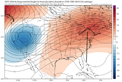
Looking ahead to next weeks active weather there where some decent trends that developed yesterday and last night. At this time, any storm that develops is likely to not bring any winter threat to the Mid-Atlantic. New England however is still in play in my opinion. 


To start here was the European ensemble from Monday morning..


Now the new image from this morning below..


Few things to notice here. For one there is more ridging on the east coast so the energy is no longer bundling (blue shades) near the coast. Instead it get pulled back further west. This is due mainly to the northern jet stream not being as involved due to a flatter ridge over Canada which you also might see comparing the two.  The result of this is a storm next week that develops well inland near the lakes..


At the end of the day this will prob still change. The reason is because there is a lot for the model to handle. We have a split flow jet stream and a bug cutoff low to deal with next week influencing this set up. In situations like this we will see a lot of flip flopping. Regardless tho, I do not expect any type of winter event to effect the Mid-Atlantic. If anything, we might end up seeing a primary low cut near the lakes and a secondary redevelop over New England. This gives the Ski Areas a shot at snow. 

As I mentioned yesterday this is going to be a big back and forth pattern through December. Given this volatility, we will have a lot of action to keep following. Whether or not its snow remains to be seen this early in the season. 

Monday, November 23, 2015

Monday Morning Long Range Discussion: Pattern is Evolving, Rumors of Storms

No, I am not just saying that. As I wrote my winter forecast back in October I was looking for certain factors to play a key role in the jet stream positioning for this winter. I mentioned how it would not be happening over night and it would be more of a slow transition. The result of this was a December being more of a back and forth month (colder to warmer vice versa) before the real winter pattern was finally established by Jan and Feb. As December is now about a week away lets evaluate what the weather pattern will look like.

Real quick before we get there, lets take a look at this week. This current cooler than normal air will last until about Wednesday. Expect temps in many areas to not get past the mid 50's with low 50's in many spots. Today will be the coldest day however w widespread 40s. 
By the time we get to Wednesday and Thanksgiving day, warmer air will work its way in due to a rise in the jet stream seen below..


Remember the jet stream acts as a barrier between air, so the rise in the jet stream lets warm air from the south build into our area later this week. Expect temps to rise closer to 60 Thanksgiving day with mostly sunny skies!

Our next round of unsettled weather comes on Saturday as a cold front approaches. Don't expect much rain with this and if anything some areas in New England get snow showers. The key to this front is that it brings in fresh cold air for the weekend as seen by image below..


It is in the wake of this front that I see this weather pattern coming alive again and showing signs of how it will behave this winter.

Looking ahead into the week after Thanksgiving we will most likely see a jet stream configuration like this


This is a set up that could case a storm to develop early to the middle part of that week. We have a ridge out west over Canada with a split flow it the jet stream. Energy gets bundled up under that flow as seen below with the blue shading near the east. IF this energy bundles enough we get a storm. Remember we will have cold air ahead of this from this weekend's cold front. The question is if a storm develops where does it track. That is too early to call at this point. Models are ranging from  a storm that tracks up the mid-west to a coastal storm. You can see the GFS as an example below..


We will hone in on this as the days go by this week. The point I am trying to make is the following: we have a lot of activity in this weather pattern. This is a theme that will continue this winter. No every storm will not effect us and it will not always be snow BUT there should be enough action to give us that shot at 30% more snow than normal like I forecasted.

Lets remember what I am expecting the overall jet stream to look like..


To make my point here is projected Jet Stream for next week's potential storm setup below..


Do you guys see what I am saying when I discuss this winter pattern "evolving". There was a method to come up with this forecast and now is a critical period to see how this unfolds. At the end of the day whether it be now or a little later in the season I think we will have a lot of action to talk about.

More tomorrow. 

Wednesday, November 18, 2015

Tuesday Morning Update: Accumulating Snow for Lakes Region, First Flakes Possible Elsewhere

Good morning. As a follow up to yesterdays post I wanted to focus on the weekend and early next week. I mentioned how the models were trending a little stronger with energy that was coming in on the northern jet stream and because of that we had to be on the lookout for a stronger storm system then modeled. Since yesterday the trend has leveled off. This means there will be a storm system that effects the Great Lakes especially Michigan and also parts of interior New England with some snow. Closer to the coast we actually do have the chance at some rain showers and maybe even some flurries for areas just off the coast Sunday. It does not look like this initial wave will develop into a big coastal storm however. That would have required even more amplification of the jet stream which will not occur. 


To start off here where initial model projections for Sunday before the stronger trend started..


Now here is the updated projection for Sunday night. Notice more focused area of low pressure near the lakes. This will put down a few inches of snow for Michigan and some areas just to the east. 


As we get to Sunday afternoon, we can see snow up in VT,NH and flurries in other areas..


Here is the accumulation map through Monday..


Looking below notice that area of rain off the coast. That is additional energy and there is a chance it can interact with the backside of the trough from the first system Monday seen below with low pressure off shore..


It appears most of this second wave stays off shore and does not develop into another storm on Monday. That can change but at this time I do not support that. In any event all of this ushers in very  cold air this weekend and early next week..

By Monday highs will be only in low 40's and lows at night below freezing in many spots. Below is 1pm Monday..


All of this is the start of this pattern change I have been talking about. When patterns change it is always a gradual transition. As I continue to look at the models, I see us on the way to our winter pattern I discussed in my winter forecast.So what does this mean?

It means that starting this weekend we will see swings in our weather pattern from mild to cold vice versa through the end of the month. In fact, we might even see temps moderate a little as we get to end of next week just to see them get cold again by the following week.  

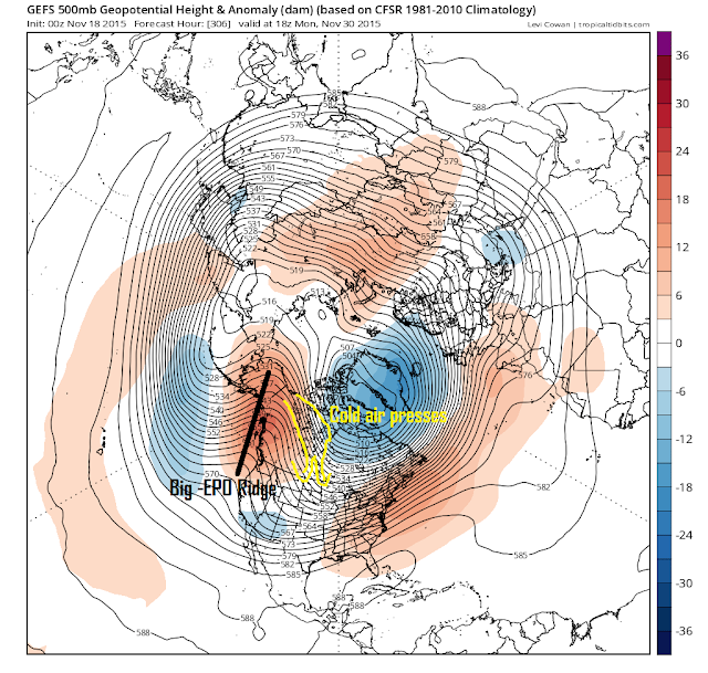
Below shows long term model projections and I want you to focus on one thing the big ridge over Alaska just off the west coast.


Anytime I see that I know the central to eastern part of the US is facing the threat of colder than normal conditions. That red or ridging you see of the east coast does not concern me. In the end I believe we will have more cold days than warm from a pattern like this due to that -EPO. 

In the end this whole process of our seasonal pattern change will take a few weeks but like I said expect a lot of back and forth weather in the meantime. As always, we will keep an outlook for any storms that might be on the horizon. For now its this system on Sunday and the slim chance for more coastal interaction early next week.

Thanks for reading. 

Tuesday, November 17, 2015

Tuesday Morning Storm Outlook: Eyeing Sunday

Good morning everyone. I am becoming more concerned that a coastal storm can develop late this weekend along the eastern seaboard. Right now this is more of a speculative post, but the trends I have seen in the last 36 hours especially with the European model hint that we need to be on the lookout.

The situation is the following. We have a big front coming through on Thursday with rain as I mentioned yesterday. In the wake of this front cold air sweeps into the region as shown by the blue colors. This is ingredient #1. Always need cold air. 


Also, we have some blocking in the jet stream to the north indicated below over Greenland. This slows down the jet stream.

The yellow circle represents energy in the northern jet stream that is projected to dive down from Canada Saturday and Sunday. Since we have an area of high pressure over Greenland and a sharper ridge than modeled previously out west this energy MIGHT dig into the east coast and consolidate into a storm.

As an example take a look at the difference between this energy on old model runs vs new ones. I want you to notice how in the new runs the ridge or red in the western US is sharper and the blue is more consolidated..

Sundays European..

Yesterday's European..

Today's European..

Again looking above notice the ridge out west gets sharper w each run and the blue near the east coast gets more focused or consolidated. This is a trend that could mean we see a coastal storm if it continues. Other models are flirting with this idea but do not have it yet, but as you all know when I see the euro start to trend I tend to take notice.

So what does it mean? At this time I say we have a 45% chance as a storm developing. IF the storm develops it looks to be rain near the coast and snow for interior New England at this time. No, I am not calling for a Mid Atlantic snowstorm, that would be way too premature given the uncertainty here. 

Regardless we got our first potential storm on the boards to track of the season! You will not hear much about this yet in mainstream until and if these trends get stronger just know we need to keep a close eye on this. 

More tonight, stay tuned. 

Monday, November 16, 2015

Monday Morning Weather Discussion: A Move to Cold and Stormy

Good morning everyone. Well, over the last week I have been trying to explain how we could be looking at a potential pattern change between the 19th and 30th. After further review this indeed will be the case. Starting on Saturday cold air will start to move in and mother nature will remind us all of what season it really is. As we head into Thanksgiving week we will also have to watch out for potential storm activity along with this pattern change. There is  also a good shot many areas see their first flake of the season next week especially up in New England. This pattern might then relax a little after Thanksgiving until the real winter pattern will set in by 2nd week of  December or so. 

Before we get there we will have somewhat milder conditions through Friday. Expect temps to be mostly in the 50's The warmest day might be Thursday with temperatures reaching the low 60's. This will be due to another big storm system effecting the central and western part of the country..


Colorado will be seeing more snow and to the east notice the big line of thunderstorms that can develop as we get into Wednesday and Thursday. This front will work its way east and effect our area Thursday with rain..


It is in the wake of this front that cold air will work its way into our area for the weekend and into next week. This is our pattern change.  The interesting thing is we are gong to have to watch for potential storm development later in the weekend to early next week. I see this mainly as a light snow threat for Interior New England. At the very least I think many of those areas have the shot for a few inches of snow by early next week. For areas more towards the coast I am not ruling out some flurries early next week!

Right now, there is not storm really on the map for late next weekend but not much would have to change for some sort of low pressure center to develop.  Looking below, we do have a lot of energy on the field..


I circled two impulses in the northern jet stream next weekend and also highlighted blocking high pressure over Greenland (-NAO) and a ridge of high pressure forming off the west cost. At this time no storm develops because the ridge is too far west and the energy never has the change to "dig" enough to phase into a bigger storm. However with that block over Greenland it would take much to change out west for the scenario later this week into early next week to result in a more focused storm with potential snow for inland areas. I will be keeping an eye on this all week to see if anything evolves.

To pull this all together and give you an overall picture of this pattern change next week the image below should to the job..


Notice we have red over Greenland and Alaska. This represents high pressure and directs the cold air south into the central and eastern United States. I show with the arrows the flow of the atmosphere. You can see how the areas of high pressure over AK and Greenland cause the cold air in Canada to funnel south. This is the opposite pattern we are currently in seen below..


So the bottom line here is that the seasons are changing. Next week feels more like late fall and do not be surprised to see a snowflake or two. No big storm threats at this time, but we can not rule out that scenario changing as we will have a lot of energy on the field next week with cold air to play with. 

That's all for now, I should have more frequent updates this week as this evolves. Exciting times ahead!

Friday, November 13, 2015

Friday Morning Long Range Outlook: Active Thanksgiving Week Ahead?

Good morning everyone. On Monday I discussed looking past the 19th for this pattern to START changing (its a slow evolution). Since then I am starting to see more evidence that things could get active for the eastern 1/3 of the country the week of Thanksgiving. I am not sure yet if this will be a permanent pattern change but I do think we at least get a spurt of cold and storminess. The overall all pattern still might be a few weeks away from its seasonal change. 

So lets take a look. To start off next week will be more of the same with a big ridge over our area and a trough over the west..


This has been the relentless pattern over the last few weeks which has brought cold and snow to the west, severe weather to the central US and warm conditions over our area. Notice that blue near AK I spoke about Monday. That is called the positive phase of the Eastern Pacific Oscillation (EPO) and it is a big contributor of this pattern. Lets now take a look at the even longer range..


Looking above look at the flip in the gulf of AK. We now have a big ridge of high pressure there projected for Thanksgiving week. This could have big implications on the pattern over the whole country.The high pressure in the gulf of Alaska (-EPO) changes the source region of the air which means it stops pacific air from entering the pattern. Instead we get the chance for arctic air to enter the country. Yes we still have that trough under it but in the long run the ridge is what is important. If we get a piece of that trough to break off and the ridge to intensify more we could be looking at mischief somewhere in the eastern 1/3. 

That does not necessarily mean a snowstorm for our area, it just means colder conditions could develop and a big storm could form somewhere between the Mississippi east Thanksgiving week. 

Moving on into Thanksgiving week, you can see the model is trying to hint at a potential trough further east. This is an ensemble which means it takes a main model and reruns it many times testing for potential error. So you have multiple members with an idea of what the pattern will look like. The fact we see the blue in different spots means the model is trying to figure out where the trough might be below. What will prob end up happening is we will see a very up and down pattern that week. There will be warm days and cold days as the jet streams wavelengths will shorten.


When its all said and done you might end up with this below by the end of thanksgiving week..


I do not think we see any snow that week but like I said colder and stormier especially by that weekend might be the issue here. Overall, I still do not see a pattern developing that supports a big east coast storm. I think we are a few weeks away from that. The main theme here is that we will start a grind from this warm mild pattern towards our winter pattern. In this process you will see a lot of variable weather conditions and storms slowly work their way more east each time. 

Be patient winter lovers we are not there yet but there is some light at the end of the tunnel. Just need to be patient. At this time we might be looking at the 2nd week of December for a permanent pattern change. One big factor to keep an eye on is the Arctic Oscillation. Lets see if that goes negative.

 Stay tuned!

Monday, November 9, 2015

Monday Morning Weather Discussion: A Late Month Pattern Change?

Good morning everyone. Well we really had a bonus week of weather last week. Who is going to complain when temperatures are in the 70's in November. Now the natural question on everyone's mind is will this continue or will things start to cool down. I will start off by saying things will start to cool down but the jury is still out on if we actually see a pattern change that would actually make it a winter like pattern.

This week will actually start off above normal but not nearly as warm as last week. Expect high temps in the high 50's to low 60's all week. We will have some possible to deal with as we head into tomorrow afternoon as a low pressure system moves just off shore to our south..


Don't expect too much rain with this, most of it will stay off shore tomorrow. But in any event it will not be the nicest day.

Moving on, We then focus on another storm system Friday that will pass to our west. This will bring showers along with it on Thursday.

The big factor this system will contribute however will be the cold air it is going to pull in for the weekend..


You can see on the image above the blue colors which represent colder air flowing towards our area Friday. This is due to the cold front from the system that effects us Thursday. As a result, by the time we get into this weekend it will really feel like mid November. 

High temps should struggle to get into the low 50's with highs in the 40's in spots for Saturday and Sunday before it warms up a little by early next week. 

Our attention now turns to the long range. We have one big factor supporting a pattern change but another that is fighting against it. Let me explain by the image below..


The image above shows areas of high and low pressure or cool and warm air for early next week. The reason I show this is because it represents the flow of the pattern. Based on the configuration determines if we have warm and mild or cold and stormy conditions. To start off, looking near Greenland I highlighted an area of high pressure. This supports colder weather as it causes cold air to try to funnel south as I show by the yellow arrow. This is called the negative phase of the NAO.

However, sometimes you need more than that and in the case above there is a big factor that is fighting against the NAO which is the big area of blue or low pressure in the gulf of Alaska. The reason this does not allow the pattern to change is that it lets pacific air flow into the country which fights back against the blocking over Greenland.  This results in variability in the weather and swings in temps from cooler to warmer vice versa.

The biggest factor I have been keeping an eye on is will the ridging or red pull back west. If that was to happen with the blocking we have over Greenland then boom you have a brand new winter pattern. The models have been back and forth with this. But we need to see the vortex over AK go away. 

So what is the bottom line? I think that between the 19th and 30th of November we see this pattern start to flip. This is based on the idea that the jet stream will shift  based on its seasonal variation. In English that means the ridging or reds shifts north and the blue or cooler conditions are underneath.

Do not be surprised to see a big storm somewhere along the eastern 1/3 of the country when this shift occurs. Some models have been showing this idea and I will go as far as saying I can see it happening sometime after this week.  

More commentary to come this week. 

Friday, November 6, 2015

Monday, November 2, 2015

Monday Morning Weather Summary: A Bonus 10 Days of Weather Ahead

Good morning everyone. Considering the Giants, Jets, and Mets all lost this weekend, lets focus on the good news which is the warm weather over the next 10 days. Yes it is now November 2nd but it is going to feel like September over the next week or two. This means temperatures will be in the 60's for high and quite possible hit 70 once or twice! At this time of year consider that a bonus. 

Lets take a look at the reasons why. Our projected weather pattern will look something like this..


The red represents warm high pressure, the blue represents cooler low pressure. Notice that the cooler conditions are along the west coast. This in turn pumps up a warm high pressure ridge over our area for the foreseeable future. Remember the jet stream acts as a barrier between two air masses, so when it rises over our area like this, it allows the warm air from the south to flow up. 

I mentioned in my post on Thursday how another big factor that is influencing this warmer pattern is the positive phase of the Arctic Oscillation. That will stay in tact over next week which also results in the cold air staying locked up in Canada. 

So does this mean the Winter is now going to be warm? The answer is no. Right now we are simply seeing the jet stream react differently in one season as opposed to another. What I mean by this is as the season moves into Winter the temperature contrasts between the north and south will get more extreme. This STRENGTHENS the jet stream. When you strengthen the jet stream the same pattern that produces the image above in one month, can produce the complete opposite in another. This is something we are going to have to watch evolve as we head into the 2nd half of November. In fact, I think the period from Nov 15th to the 30 will look much different than what you see above. This means by late November we can find ourselves in a more winter like pattern. 

But for now, lets all enjoy this beautiful weather and limited chances at rain though Friday. 

More to come mid week.

Thanks for reading.