In my video last night I outlined many of my ideas so I will be brief today. Basically as I have been saying the storm this weekend will target RI, CT, Mass, and Maine. For NYC and surrounding areas I only expect light snow. Maybe some small accumulations in the city Sat night.
Here is updated model projection..
I showed last night how the upper level low was influencing this surface outcome. Accumulations of over a foot are def in the picture here for areas near the cost up there. Very high ratio snow.
So moving on to Wednesday of next week, I have been discussing the threat for a storm. In the video last night I explained a few interesting factors behind this storm. Here is a summary of those factors below..
First look at the three numbered circles. These are disturbances in all three jet streams. All these disturbances are going to try to consolidate in into a big through by the time we get to Wednesday. Wheather or not they actually all phase remains to be seen but a phase between #2 and #3 looks more probable at this point. The bigger point here is that big black circle north of the lakes. I basically circled an area that is between two polar waves. This is mimicking a negative NAO by causing a nice confluence zone which causes high pressure to hold firm in the eastern third of the country ahead of this storm.This was pointed out by meteorologist @antmasiello on twitter.
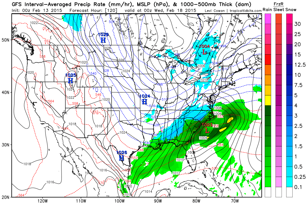
You can see that high pressure here..
This forces the storm to develop south of the high pressure..
Ok so we have a southern trend now! That is the opposite of the northern trend all winter that is the good news! The bad news? Well, we can end up getting no storm at all if this gets too far suppressed to the south. The model runs last night started to suggest this thing get too suppressed but we still need to wait for trends.
I still see the best potential so far this year for accumulating snow in the NYC and Phili metro areas from this if it pans out. Since this storm potential has been my pet project since my post on Monday I will really stay on top of this. Hopefully this suppression trend does not continue- we will see. It always is a fine line between a warm storm, a snowstorm and no storm at all.
More later.


Any accumulations In the Totowa area Tom
ReplyDeletelight accumulations possible tomorrow night, nothing major.
DeleteInteresting -- very cold weather relatively late in the season, but not correlating with the Arctic Osc, nor the NAO -- it's mostly Pacific influence, the big western ridging, reflected in a highly + PNA and - EPO (I think). No El Nino to blame, although they say that situation is rather strange right now. (Today's telecon forecasts indicate PNA going neg in 7-10 days). Good call Willy on the Southern jet getting the moisture train rolling again; we shall see if it can push the frigid heavy Eastern trough up enough this coming week (Tues - Thursday) to hit us. In the short run, some forecasters and models right now are still calling for up to 4 inches by Sunday morning in the Parkway/78/287/80 box. Would be interesting Willy if you under-called a snowfall ! But yea, the storms we've gotten thus far have been drier than predicted, even from the close-in model runs. Wow, really active patterns right now, almost as intense as a late August tropical storm approach. Staying tuned here ! Jim G
ReplyDeleteyup you are exactly right, its all pacific influence right now on our pattern. That ridge over AK is dominating the pattern. As for Sunday since it will be so cold, it will not take much liquid to pile up a few inches. Maybe near the city 4 inches but just to the west I do not see that occurring at this time, just light snow that will accumulate a little.
DeleteNext week is interesting. Right now suppressed scenario on the models but lets not forget all winter the models have ended up trending north so it will be interesting to see it unfold. I still think we got a chance on this one.