WINTER OUTLOOK 2023 IS NOW LIVE

The 2023 Winter Outlook

Tuesday, September 18, 2018

Tuesday: Florence Remnants Moving Through, Cooler Weather In Long Range

Rain from Florence remnants will work through the region today and taper off tonight. This really was the storm that didn't want to quit. No major impacts expected.

A pattern change is looming for the day 10+ period. Fall weather will finally arrive. Right now we can see cold air building up in Canada...


By the time we get towards end of next week this will really try to start pressing into the northeast...


Right on track for the astronomical arrival of fall!

This also means my Winter Outlook 2019 will be out soon! Stay tuned, we are about a month away!

Friday, September 14, 2018

Friday Morning: Landfall

Florence has officially landed near Wilmington NC as a strong Category 1 storm, making landfall early this morning...


Now the impacts will really get underway and flooding rains and storm surge slam this area for the whole weekend. Below is estimated storm surge in feet...


As you can see over 9 feet of water projected for some areas from the surge along. Combine that with feet of rain and you can see how wind is the least of our concerns right now...


The storm will now just linger as a hurricane for most of today then become a Tropical Storm. Again, the wind is not so as much a problem here as the slow crawl this storm takes...

This image shows simulated radar though Sunday afternoon!

Notice how slow this moves hence all the rainfall that is projected.

As I mentioned the other day, the reason this storm is moving so slow is due to the fact it is sandwitched between high pressure...

Lets hope for the best.

Thursday, September 13, 2018

Florence Update: A Little Weaker But Not To Be Taken Lightly

Good morning. As the sun rises today, Florence is right on our doorstep...

The storm is more ragged in appearance compared to yesterday. This is due to upper level winds or shear coming into play and preventing some of the thunderstorms on the SW quadrant of the storm to blow up. The result, which is good news, has been some weakening of the storm compared to earlier forecasts. HOWEVER, this is not to be taken lightly. This storm should strengthen today before it makes landfall tonight around Cape Fear NC. As of now it is looking like it will hit as a Cat 2 (96-110mph) winds or maybe 3 (111-129mph)...

Here is a close up of wind speeds in knots from this evening to Friday morning as the center moves onshore...


You can see the initial 2 frames (12 hours) showing the hurricane force winds hitting the NC coast. After that 12 hour period, the winds will die down to tropical storm force (under 74mph) but storm surge and flooding then become an issue as the rain does its dirty work...

Here is the total precipitation...over a foot easy in some spots...


In summary:


  • Storm makes landfall tonight as a Category 2 or 3 Hurricane with winds from 75mph to 111mph sustained
  • Hurricane winds die down by Friday morning but tropical storm force winds will maintain for most of the day
  • Storm surge and flooding will cause big time impacts along the shorelines as this storm lingers all weekend
Next update late tonight.

Wednesday, September 12, 2018

Florence Update: Making It's Final Approach, Crippling Impacts

Good morning...as everyone gets their day going Florence is picking up steam...

This is currently a powerful Category 4 storm and could strengthen to a 5 before it hits land. Just awful news for folks in the projected epicenter which looks to be the NC coast and parts of SC where a long duration hurricane (24-36 hours) is expected from Friday night to Sunday morning. Outside of those areas, the outer bands will have impacts into VA and also northern GA.

Here is updated National Hurricane Center projections...


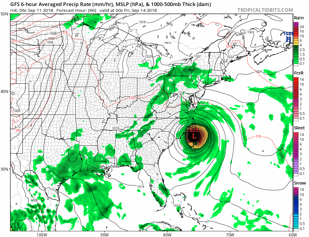
Projected landfall will be on very early Friday morning and this storm will batter the coast with hurricane winds for at least 24 hours if not 36. This is why this could be such a devastating storm. Below shows GFS wind speeds over 48 hours from Thursday night to Sunday afternoon...

Notice how it hits and basically stalls over the NC and SC coast reeking havoc on the shoreline. This is not something to be taken lightly. Those purple wind speeds are over 75mph and in the initial frames over 100mph.

In terms of track all the models now have this making landfall in NC. The only question remaining is how long does this stall out and can it move faster into land which would be a good thing.  It appears there is still a chance for that, but it is not guarantee as seen by loop above.

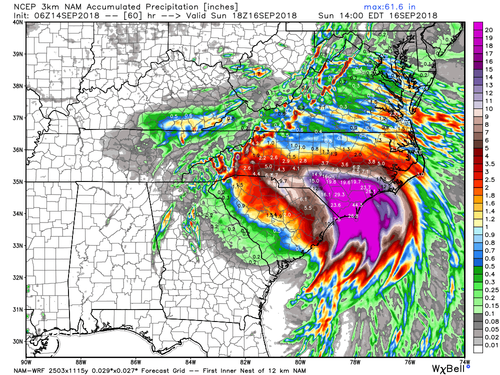
In terms of rainfall, over 2 feet of rain is possible for immediate coastal areas as seen by bright yellow...


Lets hope the people on the NC and northern SC shore lines have evacuated by now. This is no joke.


More to come tomorrow. 

Tuesday, September 11, 2018

Hurricane Florence Update: Prepare For Impacts

Good morning. Today's post will take a more detailed look at major Hurricane Florence. This looks to make a direct hit to the North Carolina coast with impacts from southern VA to SC.

Here she blows right now...


Here is the updated track from the hurricane center...


You can see the projected hit (middle of the cone) just to the south of the Outer Banks as a major Cat 3, likely a 4 hurricane. I still expect this to wobble a little to both ends of those cones. The track should be nailed down in next 48 hours.

Lets take a look at the different projections...

GFS..more of a direct Outer Banks hit...


Euro more consistently a little more south...


Regardless, the horrible thing here is that both models linger this storm due to it being sandwiched between high pressure...


The loop above is from Friday morning (main impact time) to early next week! Notice how it hovers over the coast. This is where the first 24 hours will be brutal with hurricane winds. From there flooding becomes an issue as feet of rain can fall in hardest hit spots...

As far as landfall winds, the models do differ but a Category 3 would be a conservative bet here. Looking more like a Cat 4 however..


Now considering we still have a few days before projected impact Friday morning...there still can be a slightly escape route here. Notice the northeast spread on some ensembles of the GFS...

Don't get your hopes up, even if this does trend northeast and miss a direct hit, there still will be impacts. 

It all comes down to that high pressure I mentioned that will sandwich the storm so it cant move as seen in red surrounding it...


Just not a good scenario at all here guys. By early next week a upper level trough is projected to come in and sweep this thing out if it does linger this long as seen by the high winds approaching from the west below(think of it like a highway of wind that will sweep it out as it swoops down)...

Thats all for now. More tomorrow at some point. 

Monday, September 10, 2018

Tracking Florence

Will have detailed update tomorrow morning. Too busy at the office today. This will have major impacts especially in NC.

Sunday, September 9, 2018

Sunday Note: Major Hurricane to Hit US Becoming More Likely

Detailed post tomorrow am but right now the Carolinas into VA, especially the Outer Banks look to be in the cross hairs of a high impact hurricane that can linger for an extended period of time.

The track needs to still be locked down but land impacts are now likely, its just a matter of how much of a direct blow...


The strength is likely to be a cat 3 or 4 and some model projections really do not spell out good news for the Carolina coast...


The main question right now is down this trend to impact more south or a little more north. Regardless, the storm looks to just linger as it sits off the coast by late next week.

Here is the national hurricane center track. Expect this cone to possible shift a little to the northeast in my opinion...


More details tomorrow AM. This can be a very serious situation but we still have some time.


Tuesday, September 4, 2018

Tuesday Update: Tropics Heating Up

Good morning. Now that we are in the beginning of meteorological fall (Sept. 1st) that also means peak hurricane season. As it so happens, we have a lot of tropical activity to track over next few weeks. A system is currently moving into the Gulf which will likely hit the Gulf coast as a strong tropical storm, then we have another storm or two in the Atlantic that needs to be watched closely.

Starting off in the Gulf, tropical storm Gordon is currently spinning up...

This is projected to hit as a strong tropical storm...

This could hit cat 1 hurricane strength before landfall and there is a chance it maintains that strength by the time it hits land early Wednesday morning. We will have to monitor this closely over next 24 hours. Regardless, there will be some impacts for those Gulf states.


Moving on, we then have tropical storm Florence in the Atlantic. 


As recently as yesterday, some models had this Atlantic storm becoming a threat to the east coast, as others kept it safely out to sea...

Since we are tracking something here that is over 7 days away you will see models really flip flop on what will occur.

It all will come down to what steers this storm. If a strong upper level ridge builds like seen below, (red colors) then the storm can get steered into land as seen by low pressure circle off the south coast...

If however that ridging (red high pressure) is weaker, the storm curves out to sea and gets swept away by a trough (yellowish color dipping down into storm)...

Both these images are a one day difference in European model runs. You can see the high degree of shifting from run to run. Also notice the train of storms behind it coming off the coast of Africa. 

Although there is a concerning pattern developing here with high pressure that will be lingering in the north Atlantic, historical tracks are on our side here. In most cases a storm like this should eventually get taken out to sea and not hit land. There have been examples when this did not occur and we had an impact, but I am leaning towards the no hit scenario at this time.

If we had any impacts we are talking middle of next week. 

We will then still have another 2 weeks where other storms can develop in the Atlantic basin that we will have to watch in the period to follow. 


Stay tuned!