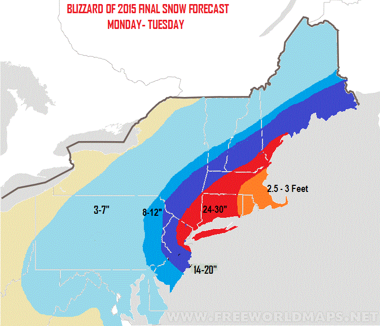
Notice I have 14-20 where I had 18-24. Not a huge change but I thought it was necessary based on the latest data that did shift things a little east. I also want to note that on the western fringes of the red zone should be a max of around 24" I do not expect 30 there. Otherwise, forecast looks to be on track.
The storm is not developed yet as seen on radar.

Look how cold the air mass is right now. All due to that arctic high pressure system that is sitting to the north. This will keep the snow ratios high meaning an inch of liquid could produce 15 or 20 inches of snow instead of the standard 10.

Tonight into Tuesday is when the storm starts cranking as that low pressure system redevelops and explodes off the coast. A simulated radar is seen below. This is when everyone needs to be on alert.

Notice the sharp cut off in snow to the west. We need to keep an eye on this and I fully expect it. That means someone towards the west can get ripped off. It is all going to depend on where the heavy snow bands set up. I will be analyzing that in real time tonight and tomorrow.
Below are the sustained wind speeds in knots tonight and tomorrow morning. You can see why there are blizzard warnings near the coast.

Need to get to work now, but expect a big update coming sometime closer to the evening hours. My goal is to keep everyone ahead of the storm. In the meantime you can find a few comments on twitter.
Stay tuned for live coverage tonight! As crazy as you all know I am by now you bet I will have footage.
Good post, you have a way of explaining storms that makes sense.
ReplyDeleteAs of Monday afternoon a few weather reporters are stating the storm is shifting further East. Even weather.com has changed the forecast in my area and reduced potential snowball dramatically.
ReplyDeleteWhat are your thoughts?
I could talk all day about weather. Weather is one of my favorite subjects and I learned about it growing up and later over the Internet. Yeah, I bought a few books about it too. It's one of those things that, as you grow older and get into a career, you wish you had done it instead of your current career. I wish I had become a meteorologist but I've done the next best thing. I have my own home weather station that I forecast my local weather with. Barrackpore
ReplyDelete