Clink the link below for snow totals. Wide spread 5 to 10 inches reported. In line with my forecast. A few spotty higher amounts than forecasted to the south but solid overall.
STORM SNOWFALL TOTALS
Friday, January 3, 2014

Final Video Update: Raw Footage
Storm is now really cranking up. Most of the accumulations will now occur until about 4 am. Below is some raw footage of the current conditions that will persist for the next few hours (now you know i'm crazy). Tomorrow will be a slow start for sure.
Current Radar: This was/is the banding that will cause the snow to pile up..
Winter is off to a nice start. More on the overall pattern for the rest of the month along with the finalized snowfall totals tomorrow. Thanks for following today.
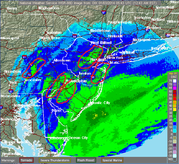
Current Radar: This was/is the banding that will cause the snow to pile up..
Winter is off to a nice start. More on the overall pattern for the rest of the month along with the finalized snowfall totals tomorrow. Thanks for following today.
Thursday, January 2, 2014
6pm Evening Update:Storm Intensity Really Ramping Up
Now is good time to get off roads this storm is really winding up and will only get worse. Blizzard conditions at times tonight. I will have frequent updates over twitter @weatherwilly, on this web post and cut another video when the storm ramps up later tonight.
Play by Play for Today/Tonight's Snow Storm
Everything you need to know in video below (snowfall totals,snowfall rates,winds,timing of storm). On another note, storm next week looks wet guys. Things can still change but the upper air support is not in place as of now for a Northeast snowstorm. Looks like an inland runner. Brutal cold however in the wake of this current storm and following the rain next week.
Here has been my going snowfall map published Tuesday morning. Some slight tweaks mentioned on this map in the video.

The National Weather Service recently updated to come in line with the same idea..
Update later this afternoon.
Here has been my going snowfall map published Tuesday morning. Some slight tweaks mentioned on this map in the video.

The National Weather Service recently updated to come in line with the same idea..
...WINTER STORM WARNING NOW IN EFFECT FROM 1 PM THIS AFTERNOON TO
1 PM EST FRIDAY...

* HAZARD TYPES...SNOW ALONG WITH AREAS OF BLOWING AND DRIFTING
  SNOW.

* SNOW ACCUMULATIONS...6 TO 10 INCHES.

* TIMING...SOME SNOW IS POSSIBLE THIS MORNING THROUGH EARLY
  AFTERNOON... HOWEVER THE SNOW WILL THEN INCREASE BY LATER THIS
  AFTERNOON WITH THE BULK OF THE SNOW EXPECTED TONIGHT AND FRIDAY
  MORNING.

* IMPACTS...TRAVEL WILL BECOME HAZARDOUS LATE TODAY AS SNOW
  INCREASES. THIS WILL BE AN INCREASINGLY FLUFFY SNOW AND AS WINDS
  INCREASE TONIGHT... BLOWING AND DRIFTING SNOW WILL MAKE TRAVEL
  EVEN MORE HAZARDOUS. ROAD PLOWING OPERATIONS WILL BE GREATLY
  AFFECTED... ESPECIALLY DUE TO BLOWING AND DRIFTING SNOW AND ALSO
  SNOWFALL RATES NEAR AN INCH PER HOUR AT TIMES DURING THE HEIGHT
  OF THE STORM TONIGHT. IT IS POSSIBLE THAT THE COMBINATION OF
  SNOW AND WIND CREATES NEAR BLIZZARD CONDITIONS AT TIMES...
  ESPECIALLY FOR AREAS FARTHER EAST.
Update later this afternoon.
Wednesday, January 1, 2014
11pm Quick Update
After studying everything closer I can honestly say I do not have much to change since my video this morning. I will have a play by play video first thing in the morning which will likely show an increase in my snow amounts in long Island and the Boston area. Otherwise I like the map I put out. This will be a moderate to strong storm with spurts of intense snow and winds especially near the coast which will really peak tomorrow night. Snow showers tomorrow turning to steady snow by later tomorrow afternoon. Heaviest snow will be tomorrow night late.
New Years Day Storm Update
Next Update Later Tonight. Totals might be upgraded a little based on the new models all trending to a more powerful storm. I want to wait and see.
In the meantime here is some eye candy courtesy of the Regional Canadian model...

In the meantime here is some eye candy courtesy of the Regional Canadian model...

Subscribe to:
Posts (Atom)