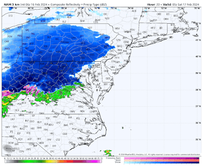
Made a few adjustments since this morning and honed on where I think heaviest snow will fall. Remember, most of this falls overnight and is over by daybreak.
WINTER OUTLOOK 2023 IS NOW LIVE
Friday, February 16, 2024
Friday: Updated Snowfall Forecast
Good morning. I made a few small tweaks to my map from yesterday to hone in on the 2-4 inch zone. Snow moves in overnight and is over before most people wake up. Very quick hitter.
At 1 am snow is moving into most places..
By 3am core of the snow is over the area...
By 7am its winding down..
Thursday, February 15, 2024
Thursday Update: Light Snow Friday Night to Saturday Morning.
Good morning. A clipper system moves into the area late tomorrow night. It is a quick hitter ending by Saturday morning. Expect light to moderate snow and colder temps. Below is my initial forecast.
I also have my eye on late next week for a larger storm. If this pans out it will prob be the last big storm threat we have for the season. Things look to warm up heading into March this year. Stay tuned for more information.
Monday, February 12, 2024
Monday Morning: Big Update, Storm Trended colder than Expected
Good morning. The evolution of this storm took some unexpected shifts overnight and will be further south and colder than I expected. Rain moves in later tonight and changes to snow before daybreak Tuesday. Snow will continue until Tuesday afternoon and will be heavy at times. This will be a major winter storm for many across the region, especially in the higher elevations.
Below is my updated forecast.
Sunday, February 11, 2024
Sunday morning: Updated Forecast
Good morning everybody. Below is my updated forecast map for Monday night into Tuesday. Expect heavy rain to enter the region tomorrow night and transition to snow in the higher elevations of northwestern New Jersey and into New England by Tuesday morning. For areas closer to the coast, some snow will fall at the end of this event but I do not expect high accumulations. This is really going to be the Poconos into New England with the highest snowfall totals. In New Jersey most of the snow snow will be confined to the Northwest corner of the state. For other areas north of 78 expect a few inches possible.
For our friends in New England you have to be about 15 miles off the coast to start to see some decent accumulations. Once you get into the core of Connecticut Massachusetts etc this is an old-fashioned snowstorm.
Stay tuned I will have more commentary out tonight and tomorrow morning.
Saturday, February 10, 2024
Winter Storm for Some Tuesday
Good morning. A storm will impact the region Monday night through Tuesday. An initial batch of rain will change the snow for many areas. The snow could be heavy to the north. Below is my initial estimate for this event. I will have another update on this map tonight. Stay tuned a lot of details to come.


