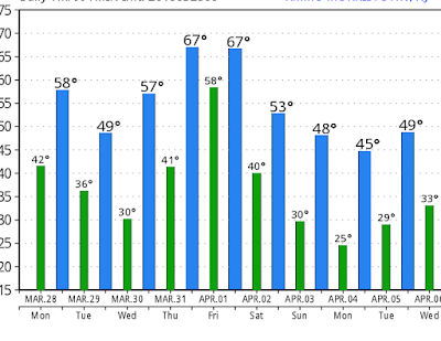
Good morning everyone. Hope everyone had a nice Easter weekend. For the most part the weather worked out nicely with seasonable conditions. This week will feature more moderate conditions with rain at times and temps mostly hovering in the 50's to low 60's By the time we get to the end of this weekend we will see a very impressive shot of arctic air move into the area. This can bring temps up to 30 degrees below normal, all due to a visit from the polar vortex.
Starting off today, we have rain moving through the area currently..
This moves out by the afternoon and leaves high pressure in controll tomorrow with cooler conditions in the 50's. Things then start to warm up Wednesday and Thursday ahead of a front that will be bringing showers and possible storms for Thursday afternoon through Friday morning..
This should be cleared out by Friday afternoon. In the wake of this frontal passage the flood gates are going to open to true arctic air by late this weekend. Saturday starts the cooldown with temperatures back into the 50's but we will all start to notice the chill by Sunday The image below shows the expected temperature departures from normal by early next week..
Image below shows departure from normal temps. Notice we could see over 20 degrees C below normal. In F terms thats almost double. I would settle and say seeing up to 30 degrees below normal is not out of the question. This is all due to a direct visit from the polar vortex..
This is as impressive as it gets for early April. Notice the big ridge of high pressure over Alaska extending into the arctic. This is what allows the plunge of arctic air directly down into the United States. A true cross polar flow! If this was early February we would be seeing sub zero temps in many areas for lows! This airmass sticks around most of next week but should moderate a little as we head to the following weekend.
Here is a general idea of temps through early next week. We could see things go lower in many areas but the projection below is a safe estimate.
Now the big question is can it snow. The answer is seeing snow showers especially on Sunday with the passage of the arctic front is very possible. GFS shows this..
In terms if a storm, we would have to look for something to form on the backside of this arctic outbreak or in other words as the air mass is getting ready to depart towards the end of next week. I would not get your hopes up but it is not out of the question. In the meantime a clipper system or two could swing through providing light snow middle of next week. GFS and other models try to show this for next Tuesday..
We will see if this amounts to anything. The point here is that the airmass is cold enough to support snow.
I will keep my eye on all of this and let you guys know if I see anything interesting starting to evolve. For now just expect very chilly conditions with the chance at snow showers early next week.
Thanks for reading.


No comments:
Post a Comment