WINTER OUTLOOK 2023 IS NOW LIVE

The 2023 Winter Outlook

Thursday, March 31, 2016

Thursday Morning Note: Quick Update on Next Week

My thoughts have not changed much since yesterday. Everyone experiences the big chill late this weekend into early next week but not all will be impacted by accumulating snow. At this time I still favor New England for accumulating snow next week. I think with Sunday's passage of the arctic front everyone sees snow showers including the tri-state. A few inches might accumulate further north. On Monday night into Tuesday a clipper system should target the I-90 corridor (NY state into Mass). Flakes will prob fly near NJ, PA but I do not expect anything news worthy. We then still are on track for a bigger storm next Friday which could cause big issues for interior New England especially upstate NY.

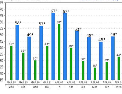
So to start off, here is updated look at temps Sunday morning as the chill arrives..


This is very cold for early April. Highs will not get past the low 40's on Sunday for the Tri-State. Much colder to the north. 

On Sunday we have the arctic front that is responsible for these temps. I expect some snow showers possible as this front moves through..


We then have our clipper that moves in later in the day on Monday through Tuesday afternoon..


Several inches of snow is possible up in NY state into Mass, VT, NH, especially higher elevations..


We then will be watching how a potential bigger storm evolves for late next week. Big model spread still on this concurring. If this storm does form it would target the interior especially NY state. Stay tuned for details on this. 

I will have a video out tonight breaking all of this down more. Its April and we still got weather to talk about!


Wednesday, March 30, 2016

Wednesday Morning Weather Update: A Closer Look at Next Week's Winter Weather

Good morning everyone. As I mentioned on Monday we will have a big chill coming to town next week thanks to a visit from the polar vortex. The natural question is can it snow? The short answer is yes but I wouldn't get my hopes up for anything substantial in the big city areas. 

Here is an updated look at the arrival of the big chill Sunday..


Air temperatures will be up to 20 degrees below normal in spots of the northeast early next week. This means highs in the upper 30's to low 40's and lows in the 20's. Much colder to the north obviously. 

As this cold shot arrives, it can bring with it some snow showers Sunday..


We then turn our attention to a potential potent clipper system for Tuesday. Models have been ranging from showing a decent accumulating snow event somewhere between the Mid-Atlantic and New England. Latest guidance has brought this more to the New England front..


I am leaning more toward this camp. This would give New England at shot at accumulating snow. It can happen guys but its very rare to have a big accumulating snow event in the Mid-Atlantic in early April. You will find that models tend to over exaggerate events a week away just to adjust to reality. This is why I didn't even bother to comment yesterday on the European or Canadian model that showed a foot of snow in Northern NJ. 

In any event, you can see this can pack quite the punch for New England Tuesday..


We will focus more on this in the days to come.


Moving on, this pattern still has some juice left for later next week. Long term models have signals all over them that a bigger storm can develop end of next week on the heals of this arctic air mass. I always say look for storms on the front and back of big arctic invasions. In this case here is what the models are showing for its backside..


This is from the European ensemble valid Friday next week. Sure its a long way off but this projection of pressure placement does argue for a storm to develop somewhere in the east. If we go to the surface it has a low projection average here..


I am going to keep my eye on this as it really has my attention. Again, I am not calling for a big city snowstorm here I am simply stating that a bigger storm is possible. In terms of snow, I would naturally say interior New England would have the shot if everything came together correctly. 

So in summary, we have as much action on the table as you can possibly have for early April. A major late season cold shot arrives Sunday, followed by two shots at winter weather Tuesday then later next week. I favor interior New England to see anything substantial when it is all said and done. Mid Atlantic areas I would put at the shot of seeing a few flakes or a light accumulation when it is all said and done. 

Stay tuned for more details! Might have a video coming this week. 

Monday, March 28, 2016

Monday Morning Weather Outlook: Chilly Unsettled Week Ahead, Arctic Plunge Follows

Good morning everyone. Hope everyone had a nice Easter weekend. For the most part the weather worked out nicely with seasonable conditions. This week will feature more moderate conditions with rain at times and temps mostly hovering in the 50's to low 60's By the time we get to the end of this weekend we will see a very impressive shot of arctic air move into the area. This can bring temps up to 30 degrees below normal, all due to a visit from the polar vortex.

Starting off today, we have rain moving through the area currently..


This moves out by the afternoon and leaves high pressure in controll tomorrow with cooler conditions in the 50's. Things then start to warm up Wednesday and Thursday ahead of a front that will be bringing showers and possible storms for Thursday afternoon through Friday morning..

This should be cleared out by Friday afternoon. In the wake of this frontal passage the flood gates are going to open to true arctic air by late this weekend. Saturday starts the cooldown with temperatures back into the 50's but we will all start to notice the chill by Sunday The image below shows the expected temperature departures from normal by early next week..


Image below shows departure from normal temps. Notice we could see over 20 degrees C below normal. In F terms thats almost double. I would settle and say seeing up to 30 degrees below normal is not out of the question. This is all due to a direct visit from the polar vortex..


This is as impressive as it gets for early April. Notice the big ridge of high pressure over Alaska extending into the arctic. This is what allows the plunge of arctic air directly down into the United States. A true cross polar flow! If this was early February we would be seeing sub zero temps in many areas for lows! This airmass sticks around most of next week but should moderate a little as we head to the following weekend. 

Here is a general idea of temps through early next week. We could see things go lower in many areas but the projection below is a safe estimate. 


Now the big question is can it snow. The answer is seeing snow showers especially on Sunday with the passage of the arctic front is very possible. GFS shows this..


In terms if a storm, we would have to look for something to form on the backside of this arctic outbreak or in other words as the air mass is getting ready to depart towards the end of next week. I would not get your hopes up but it is not out of the question. In the meantime a clipper system or two could swing through providing light snow middle of next week. GFS and other models try to show this for next Tuesday..


We will see if this amounts to anything. The point here is that the airmass is cold enough to support snow. 

I will keep my eye on all of this and let you guys know if I see anything interesting starting to evolve. For now just expect very chilly conditions with the chance at snow showers early next week. 

Thanks for reading. 

Thursday, March 24, 2016

Thursday Weather Update: A Nice Easter Weekend Ahead, April Cold Shot

Good morning everyone. We have beautiful spring weather underway. Temperatures will hover in the low 60's today and hit the low 70's tomorrow. We will see some showers tomorrow as a cold front moves through the area.


This will all clear out by later in the day Friday paving the way for a nice weekend with sunshine and temperatures in the low 60's. 

As we head into early next week a storm will effect the area Monday with rain..

Still watching how this evolves. I would not be surprised to see some frozen precip up in extreme northern New England on the backside of this. In the wake of this storm, temperatures should warm up next week possibly into the 70's by Thursday and Friday. 

Our attention will then turn to an impressive cold shot that is expected to dive down into the area the first week of April..

The image above shows the temperature anomalies projected by the European ensemble. In many areas, especially in the central US it could feel more like late February rather than early April. I expect temperatures to become very chilly over our area as well during this period. You can see below the projected position of the jet stream..


This is very impressive. Anytime you see such a powerful ridge of high pressure over Alaska (seen by red colors) its response is to drill down cold air from Canada to the east. You can see this projected on the map by the blue colors flooding the country. This is called an negative Eastern Pacific Oscillation pattern. Due to the projected magnitude of this cold shot we can not rule out seeing flakes fly again before it is all said and done. No I am not saying we see a snowstorm but I am saying snowflakes would not be out of the question with an air mass like this. Up in New England anything goes.

So we will see how this long range pattern evolves. For now enjoy nice nice weather ahead and Happy Easter!


Monday, March 21, 2016

Monday Morning Weather Discussion: Storm Summary and Week Ahead

Good morning everyone. What a roller coaster ride it was tracking this storm (or lack there of) over the last week. It is no secret I had a tough time with this one as many did. I have never seen models so volatile so close to an event before. Even using non modeling methods like historical analogs did not help me much! Here are some of the latest snowfall reports coming in. This map will be updated later today with final numbers..


I have heard of a few 6 in amounts so far in CT and Mass. Snow is still falling there and when it is all said and done there will be some areas of 6+. You can see the radar is currently cranking over that area.


Nice moderate bands of snow currently extending from Mass up into eastern Maine right now. This snow will accumulate more over the next few hours. 

For NJ it was a complete bust, even for the 1-3 inch amounts! Its amazing how when you study this storm the difference between a dusting and a foot was so small when looking at the upper atmosphere Literally if the upper air disturbance diving in from the midwest was a little faster this would have been the big one models were showing on Thursday. At least some areas in ENE lucked out. My maps did ok up there overall. 

Moving on to this week, temps will start to warm up by mid week reaching the mid to high 60's. A cold front then approaches by the end of the week bringing the chance for some unsettled weather Friday..

This cold front Friday is associated with a big snowstorm that will be moving through the Midwest middle of this week. The end result will be a chilly weekend with temperatures in the 50's for many areas. 

As we head into next week the weather pattern stays more on the chilly side. This should continue into early April. This is all due to a persistent ridge of high pressure developing over Alaska..


This will keep things cool and stormy especially over the central and eastern CONUS. Keep in mind it is late March now so cooler than normal is nothing we all can not handle. 

Could we see flakes fly again? Sure we could, but the chances at anything substantial are extremely low. At this point you want to just root spring on and look forward to next winter. 

Now spring is no slouch weather wise. We have severe weather to track which should keep things interesting. As we head deeper into the warmer months I will be releasing weekly weather summaries every Monday morning then updating during then week when appropriate.  I will also do a review of my winter forecast sometime over next few weeks. It did not do great this year but I always like to still tally up the points. 

Thanks for checking in. 


Sunday, March 20, 2016

Sunday Morning Storm Update: Final Snow Forecast

Good morning everyone. Below is my final snowfall forecast. I had to make some adjustments to totals especially near Eastern New England where this will be a formidable event. For NJ all areas should see flakes fly. I expect eastern sections of the state to see a few inches accumulate on grassy surfaces. 


In process of cutting a video to break it down. 

9am Update on Tap

Final map for what to expect later today will be up.

Saturday, March 19, 2016

Special Afternoon Update: Model Mayhem, Anything Goes, No Holds Barred!

6pm note: westward trend continues. This will have some impacts on the going forecast. Map will be updated late tonight/early tomorrow morning. 

<<<<<<<<

Will keep updates rolling through tomorrow morning with any necessary changes. Sticking with my snowfall map for now. 
>>>>>>>>>>>>>>>>>>>>>>>>>>>>>>>>>

We still have updated model guidance that is to the west! I discuss in video below. This will keep us on our toes for next 24 hours stay tuned. I am not changing my map. I just want to make you all aware how volatile this situation is. I have never see such high model variance so close to an event.


Saturday Morning Update: This Ones For The Birds

Good morning everyone. Well, it was fun to track while it lasted. Our beloved storm threat will stay out to sea this weekend with limited impacts on the tri state area. Up in eastern New England there will be impacts that I will discuss.  This is going to end up being a huge win for the American model suite as it has had this scenario the longest. The higher skill models such as the European, its ensembles, and the UKMET really got burned this time. I will admit I am surprised at the shifts we saw in those higher skill models starting yesterday morning. It did throw me off. Usually 72 hours out you do not see that occur.  Oh well, its more of the same and is quite the appropriate way to end off winter of 2016 with another miss. 

The GFS model is an interesting beast. Its known error bias is to keep things too flat and out to sea. In most cases when you see the GFS out to sea with other major model guidance a hit, it tends to correct back west. However, this is not the first time it scored a big win. Every so often it does pick up on something the other models do not see and what can be mistaken has some merit in it. This usually is apparent when within 72 hours it keeps holding its ground. That appears to be the case this time and some of us are left holding the bag.

So here is a quick summary:


  • Storm mainly stays offshore this weekend with limited impacts over the tri-state
    • expect some snow to break out Sunday with 1 to 2 inches of possible accumulation. 
    • There should be no travel impacts
  • Up in eastern New England especially eastern Mass, impacts will be greater
    • 3 to 6 inches can fall in those areas
Here is updated map. I threw a bone to some areas with the light blue. 1 to 2 is possible but do not get your hopes up. 


The image below shows the storm just skirting by our area tomorrow..


This then could intensify close enough to shore to give the Boston area a notable snow event..


The weather is and always will be a chaotic phenomenon. There is no one perfect model. When I look back on this last season we saw every model have its highs and lows. Think of the NAM model which nailed the Blizzard but usually is always wrong in every other case. Or the UKMET model which was nailing those inland runner rainstorms but completely whiffed this time. To try to combat this, they develop ensemble forecast systems to take these main models and adjust their input values to account for possible errors. You then get up to 51 reruns of the main model and can see where each member is leaning. Probability tables are developed and statistically it sounds like we have a great handle on a situation. Well, not so fast. The mighty European ensemble really failed this time. For the most powerful forecasting tool in the world (just upgraded too) take a look at what it was suggesting just the other day..

You can see each ensemble members listed by the low pressure centers. Notice the strong signal that this storm would trend west as seen by the clustering of those members. If you averaged it all out you got a snow map that looked like this..

This obviously ended up being completely wrong despite the fact the probability of 6+ inches of snow over NJ was over 60%! Get used to it guys it happens all the time! This is why the weather will always have my interest. As humans even in the year 2016 our most powerful computer modeling can completely miss as close as 72 hours away. This is what will always keep my hobby alive.

Thanks for reading guys. It just was not our year.You will find that in other years it will simply just want to snow. This year it did not want to snow. That brings me to the old saying "it snows where it wants to snow" Sometimes simple tag lines like that make a lot of sense when you look back at a season.

Will have a few updates later and tomorrow as this storm approaches.

Friday, March 18, 2016

Friday Night Video Update: Latest Verdict on This Weekends Storm

The video below gives my latest thoughts and reviews today model guidance. Here is the summary:
  • A storm still looks to effect the east coast Sunday
  • There are currently two scenarios on the table
    • Scenario 1: storm stays out to sea with limited impacts
    • Scenario 2: Storm develops close enough to the coast to give many areas a moderate snowfall.
  • At this time I still am favoring scenario 2
  • I like the snow map I put out this morning with the band of 3-6 inches and will update it tomorrow morning
    • You will likely see amounts get adjusted downwards near Balt/Wash Phili areas due to warm surface temps
  • Overall I do not expect major travel impacts due to those warmer surface temps for the NYC metro
    • We will have to watch NW of I-95 in NJ if this storm trends a little west as temps will be colder
  • Up in New England road impacts will be greater due to the storm approaching closer to dark
  • Storm should be completely over by Monday morning

More info in the video below. Stay tuned for updated map tomorrow morning.


Friday Morning Storm Update: Hes Cut!

Good morning everyone. I tell you when it comes to tracking storms there is never a dull moment even within 50 hours of an event. The best way I can describe last night model runs is with the image below..


Let me explain the metaphor here. For you Rocky fans, pretend the European model is Ivan Drago and the GFS is Rocky. As unstoppable as the European model seemed all week, the GFS has just come in with a huge right hook last night knocking it off its axis. Translation: Last nights European model run has shifted east towards the GFS! Now when we try to forecast you can not be impulsive but you need to try to stay realistic. We all know how Rocky IV ends and I will discuss my updated view on the fate of this storm below. 

Here is a quick summary of my updated thoughts. I also have an accumulation map below. Warning, confidence levels are not high at this time. You can see why I wanted to wait till this morning to make the map.  

  • Winter storm targets the northeast Sunday into early Monday
  • There is a chance of snow for all areas extending from Baltimore/Washington up into Boston. 
    • The intensity of this snow is still a big question mark and will all depend on the track of this storm
  • At this time most major models are folding towards the GFS models more east solution
    • This could be a red flag and we need to take this seriously
  • The more east solution means a lighter snow event and less impacts further inland into PA and Update NY, VT, NH
  • WE CAN NOT JUMP TO ANY CONCLUSIONS YET
    • However today model runs should tell the tale
  • My map below is my best efforts at accumulations 


I am taking the middle ground here with snowfall. I will hone in and tweak this to a final forecast this weekend. At this time the darker blue is where the heaviest accumulations could be. This is not just based on precipitation intensity but also surface temps. The 1-3 inch area will have a warmer surface so snow will not accumulate as easy. 

So lets take a look at modeling. The European model overnight caved to the GFS. I will admit I am very surprised at this...


Here was the GFS..


The Canadian is still very aggressive but did shift east..


This is all due to the energy in the upper atmosphere being flatter and not as amplified. I talked about this yesterday. 

So here is the bottom line. The models are obviously picking up on something here which is causing the east shift. Kudos to the GFS for picking this up the earliest. One of two things will happen from here. One, the models continue jog east and this is a very minor event (bust) or two, there is a little bit of a jog back west and this is more significant. My map above is based on a slight jog back west. 

We will see what the data looks like today. I will update around 5pm.


Thursday, March 17, 2016

Thursday Night Storm Update: Major Winter Storm Becoming More Likely

The video tonight gives you guys my latest take on this potential major winter storm Sunday into early Monday. Higher scoring models such as the European and UKMET were very impressive with their evolution today. I like the map I put out this morning as a general idea of impacts. I will release my first accumulation map first thing tomorrow. Here are some highlights:


  • Chances increasing for major winter storm Sunday into Monday
  • Highest impacted areas should be north and west of I-95 with significant accumulations
    • I would expect to see around 6-12 inches for that region
  • To the south and east of 95 I expect accumulating snow but with mixed precipitation and some rain along the immediate coast
    • Lower amounts here on the order of around 3 to 6 inches
    • This includes NYC, Philadelphia, and Balt/Wash
    • I base this on my interpretation of how this storm will trend next 48 hours
  • Height of the storm is Sunday night into early Monday morning


Thursday Morning Storm Discussion: My Preliminary Thoughts

Good morning everyone. As I discussed in my video last night we had some pretty big developments yesterday with the evolution of our storm threat for Sunday into early Monday. In particular, models began a westward trend. Over the next few days they still might wobble back and forth, but I am ready to give you guys my first speculation on what I think will happen with this system. Obviously I will have to update this as the days go on. 

Here is a summary:


  • Big late season winter storm effects the east coast Sunday into Early Monday
  • The storm is by no means a lock but Weatherwilly is gaining confidence on this occurring
    • There is still a scenario on the table where this goes out to sea
  • An outbreak of arctic air precedes this storm on Saturday
    • This will aid in supplying the fuel necessary to produce snow for many areas
  • Low pressure then develops in the Gulf of Mexico and tracks northeast as it rapidly intensifies aided by approaching northern jet stream energy
  • For estimates on impacts, I would not be surprised to see this storm trend a little more west
  • This would mean..
    • All areas start off as snow Sunday
    • Mixed precip and some rain develops in areas south and east of interstate 95, especially along coastal areas
    • Areas NW of I-95 up into New England gets the brunt of this system in terms of possible accumulations
Here is a visual representation of my projected impact zone. No accumulation maps yet, but significant accumulations are possible in highest impact zone. 


The map above is my take, not just what the models are spiting out. If the storm shifts away from my ideas I will be adjusting this.

So lets dive in to some updated modeling.

The GFS is still playing games trying to keep this storm just off the coast..


The European, UKMET, and European Ensemble System are all to the west of this. Below is the UKMET model which looks very similar to the European...

I really like the track the UKMET is showing, it makes a lot of sense to me. This model has done an excellent job this winter and usually when blended with the European is a good tool to use. 

So why am I not buying the GFS? Is it because I just want it to snow? Well, I try my best to eliminate that bias but let me show you what I am looking at..


What you are looking at above is energy in the atmosphere at 18k feet. This energy comes together to produce storms. The two circles areas represent the GFS model's prediction of how this energy is handled. Notice how it looks stretched out. This is an error that the GFS tends to make and the result is a storm that is projected to go out to sea due to the energy not consolidating properly. Below is what I think this should look like instead..

Might be hard to tell but in this image that energy is not as sheered out and results in a storm that is closer to the coast. We should start to see the GFS correct west next 2 days. If it does not then that will be a red flag to me that my ideas might be wrong. 

So thats all for this morning. We have a very exciting late season snow threat on the boards and we will get even more helpful data today. 

I will have an update tonight up around 830.


Wednesday, March 16, 2016

Wednesday Night Storm Outlook: Big Trends Today, Storm Threat Increasing

Models have started a shift west today with the storm threat for Sunday into early Monday. This was a critical time to see this trend develop and it is making me lean towards this storm becoming a legitimate threat for all areas along the I-95. I actually would not be surprised to see this trend even more west next few days which would result in a snow event from I-95 to the NW with snow to mix and rain near coast. I will have a preliminary impact map tomorrow. Lets see how this evolves. I will do my best to give you my interpretation of everything. 

Video below breaks this down in more detail. More tomorrow. 


Update Tonight at 930

Afternoon runs of models really spoke loud today. Trends back west. My take will be live tonight. Stay tuned.

Wednesday Morning Update: Offshore is the Latest Consensus For Now

Good morning everyone. Lets dive into latest trends on our storm threat for late this weekend. I discussed yesterday how there were more progressive or offshore trends emerging with this storm. This meant that the chance of an inland runner where diminishing rapidly. Today is more of the same. Most model guidance is just offshore with this system and way too close for comfort. 

There are two clear scenarios here. Scenario 1 is a storm that stays out to sea and scenario 2 is a storm that comes up the coast effecting areas I-95 north and west with winter weather. At this time its a 50/50 shot either way.  By tomorrow morning we will know a lot more.

So lets take a look at what is going on. Most models at this time look something like this..


The reason the storm is offshore is due to the interaction of energy on the models.


Looking above you can see the northern stream and southern stream which are circled. This storm all comes down to how they interact. As stands most models are a little too flat with the amplitude of the northern stream. This sheers out the energy a little bit and causes a late interaction between the two. A lot of this has to do with weaker blocking then originally projected. Over the next 36 hours we will see if this trend holds. IF we get this to sharpen more then we get a big storm closer to the coast. An example of what that would look like is below..


Notice on this image how the southern feature is stronger and the northern feature is sharper or not as flat. This causes a storm that would be closer to the coast as seen below..


This is the DGEX model which is basically the NAM model extended. Its not too reliable but it shows you guys what the other scenario would look like. 

One major factor that we know will be in place is cold air ahead of this. A fresh arctic injection comes in this weekend ahead of this storm (seen below). This means if this storm trends back west then we will be dealing with widespread winter weather..


We have 4+ days of model data to go and things will change here. The difference between both scenarios is just a small interaction at 18k feet in the atmosphere between the northern and southern stream I have shown. 

We have had two days now of more progressive or offshore trends. That doesn't mean too much YET, but one more day of these trends and I would lean more towards the offshore solution. I can not write this off due to the fact all the players are on the field to bring this up the coast.

Lets see what happens today and I will then put out a preliminary outlook. 

More late tonight. 

Tuesday, March 15, 2016

Tuesday Morning Weather Discussion: Latest Storm Trends on Models

Good morning everyone. As I started discussing yesterday I am tracking a storm threat for late this weekend/early next week. The atmospheric setup look ripe in terms of the players we need to see on the field. Now it will all come down to if these players want to come together correctly to form a big storm. At this time I am still not seeing large support for a I-95 or big city event. Climatology it is very hard for that to occur this time of year. It can happen but everything would have to really come together perfectly. For greatest impact I still am focusing on the interior.

With that being said, latest model trends have been more east and more progressive with this storm threat. I am going to use the European ensemble system to show trends.  


Looking above you have the old run of the euro ensemble on the left and new run on the right. Very hard to tell but the right image is flatter with the slope between the red and blue zone. Also notice out in the pacific the blue blob is closer to the coast on the right image. This represents a more progressive trend in the energy. This means the flow is faster on the new run which pushes the energy more to the east. At the surface the result is the new ensemble mean low position being to the east as seen below..


This latest trend actually helps with the forecast here. To me, it starts to eliminate the possibility of an inland runner. It will now come down to will this storm effect the northeast or go out to sea. It really is too early to tell but we will learn a lot over the next 48 hours studying these trends.

The GFS is on board with the out to sea idea (as it always is this far out). Keep in mind this is an operational model below and the images above are ensemble means. I would focus on the ensemble means for now. 

The European operation is similar to its ensemble with a low just off the coast..


The most aggressive would be its ensembles control run which is really juiced up. Likely this is overdone..

So as always we have a model spread but the clear trend is more east today with this. If this progressive trend continues it would eliminate the storm threat. I am not ready to speculate yet until one more day of model data. Thanks for reading, more to come.