Good morning everyone. I wanted to give a special update on projections for a tropical storm/hurricane that could impact the SE United States next week. This is only a preliminary update and as the days go I will go into more detail, but I want to give everyone an idea of what is currently going on. The potential impact timing is early to mid next week.
Lets start off with the current situation...
Looking above you can see we have a tropical system just to the north of S. America. This is tropical storm Erika and it has been developing over the last 24 hours. The National Hurricane Center has issued this outlook..
You can see the cone which represents its possible tracks and the timing they are expecting for this system. The H in the black circles represent that they are expecting this to develop into a hurricane. It is not a surprise that if you compare the current model spread to the NHC's track it looks similar below..
You can see that at this point many models are pointing to a storm that either hits southeastern FL and then curves northward or in some cases drifts into the Gulf. In order to determine which solution will be likely we have to monitor the upper level pattern which steers hurricanes.
Looking above at the GFS Ensemble you can see a big ridge over SE Canada, and a circle off of GA which represents the storm. The placement of this upper level ridge (red colors) is key. If you get that ridge slightly more east or west it will have a drastic impact on the trak of this storm. That is what will determine if it skirts FL and goes out to sea or its more of a direct land hit. I am not ready to jump on any solution yet. I just want you guys to know this track can change over next few days even tho the model spread says one thing.
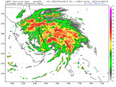
Looking at an actual projection of the HWRF model (special hurricane model) of where it expect this to make landfall. Below is the simulated radar..
Just one model projection, but it is a model that will be come more relevant as we get closer to the event.
Stay tuned I will be updating daily as this situation evolves!


This one has become interesting! You've got warm Caribbean waters, but wind shear coming in from the Pacific (El Nino), interacting with the dry dusty air from the African Sahara . . . and over the next 40 hours, Erika will roll over the mountains of Puerto Rico and Hispaniola. Lots of crazy physical dynamics happening that overwhelm our existing data gathering and data processing capacity. Thus lots of uncertainty, with model outcomes changing significantly at every 6 or 12 hour run. I've read that Saturday morning is when the models will settle down and get serious, and we will get better ideas of intensity and likely track. I gather that even if Erika then strengthens and were to turn northward, it doesn't look like it would track anywhere close to the NY Metro area, assuming that the big ridge over eastern Canada stays put. Not that we couldn't use the rain. Thanks for the updates, Willy. Jim G
ReplyDeleteI agree Jim. Im not going to lie I can't pin down the track of this yet but I do not see our area as being anywhere close to the main hit zone at this time. Once it crosses those mountains we will have a much better idea of where this thing goes and also how strong or weak it gets due to those factors you mentioned. Hey, at least we got something to track in the non winter season! Makes me look forward to Winter (hopefully its not a warm mild one). Thanks for reading Jim.
Delete