WINTER OUTLOOK 2023 IS NOW LIVE

The 2023 Winter Outlook

Friday, April 29, 2016

Friday Morning Weekend Outlook: Unsettled Weather On Tap

Good morning everyone. The good news is we are finally at the weekend. The bad news is it will not be the nicest weekend overall. We have a few rounds of showers to deal with from this afternoon through Sunday night. Saturday looks like it can be spared at this point, but temps will still be in the high 50's to low 60's.

Starting off with today, showers should develop by this afternoon as a upper level short wave spins up the air..


This will be more of a nuisance than anything but it still will keep things feeling more on the damp side.

High pressure then tries to build back in for Saturday which will cause some clearing and temperatures in the high 50's to lower 60's


On Sunday, a stronger more moisture rich low pressure system enters the area causing  scattered showers and eventually a steady rain to develop by Sunday night..


All this should linger through Monday then finally clear out by Monday night into Tuesday.


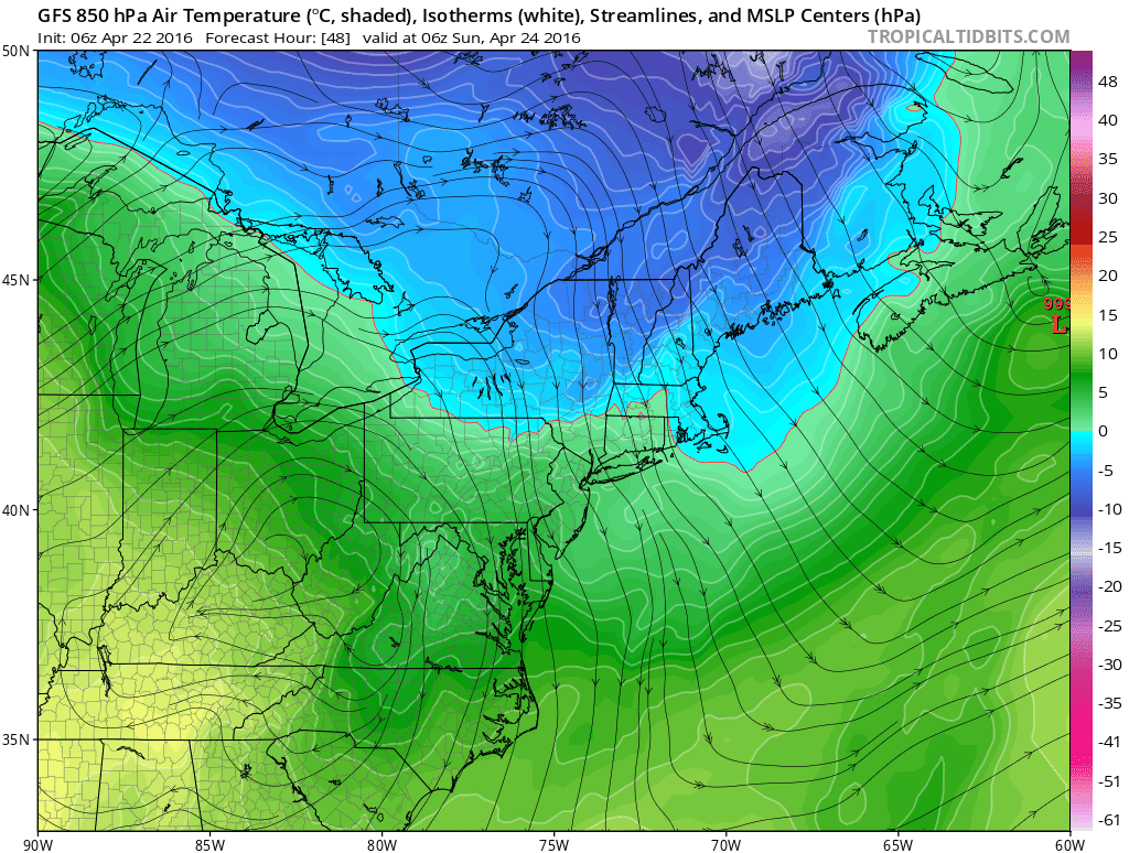
All this unsettled weather is due to a parade of upper level energy flowing through the area from the north and also from the west. The image below shows this..

Frontal boundaries between warm and cold air develop and as each disturbance in the upper levels move through, it acts to "spin" up this warm and cold air causing unsettled weather and low pressure systems to form.

You can usually see these frontal boundaries by looking for something as simple as the dew point. Why? Well colder air holds less moisture than warmer air. Below I highlighted where this frontal boundary currently is using the dew point..


Again each one of those upper level disturbances I showed before spins this air up causing the rain we are seeing this weekend. 

Thats all for now thanks for reading. 

Tuesday, April 26, 2016

Showers and Storms Today

Below is the simulated radar valid for around 3pm today. A few isolated very strong storms are possible especially near SE PA down into MD. These storms will fire up as a cold front moves through the area. 


I cut a video last night below discussing the potential for tornadoes today out west. Check it out if interested. 

Monday, April 25, 2016

Severe Weather Tomorrow Out West: Tornadoes Likely

Dangerous situation for areas in the nations heartland tomorrow as conditions are favorable for supercell thunderstorms and tornadoes. Video below breaks it down. ..


Monday Weekly Weather Summary: Warm Weather Gives Way to Seasonable Conditions, Severe Weather In Heartland

Good morning everyone. It ended up being a beautiful weekend with the exception of some lingering showers on Saturday morning. As we head into the front part of this week we will have more beautiful conditions today with temperatures in the mid 70's. 

As we head into tomorrow we will have some unsettled weather move our way with showers and Thunderstorms possible through tomorrow night..


Notice the colder air in New England. This is not snow for anyplace but the  Green and White mountains Tuesday. I do expect those ski areas to see some flakes mixed with rain as there are arctic origins from the air mass entering the area. Accumulations are possible there. A big part of how the colder air is locked up there is the big blocking high we have over Greenland right now..


This -NAO pattern allows colder air aloft to get trapped near the east as seen by the pocket of blue near New England. However the bigger issue this week lies out west. Take a look at the pocket of blue over Nevada moving towards Nebraska, Kansas and Oklahoma. This represents an upper level low pressure system which will be moving directly into warm moist air. 

When you get cold air aloft running into warm moist air to its east severe weather is in the cards. There are many factors needed to support a severe weather outbreak and on Tuesday many of those will be present for the nations heartland. I am going to go into more detail tonight in a video but he easiest way of showing how unstable the atmosphere will be is by looking at a parameter that shows the potential for how much a parcel of air can rise. The more air rises the more it cools and condenses and the bigger thunderstorms can get. Here is what this parameter  looks like for tomorrow..

Some very extreme values especially over Nebraska and Oklahoma. We also will have a strong sheer or wind direction change from the lower levels to upper levels which will aid in causing the thunderstorms to spin. You can see this below where I circled the difference between winds at 18k feet and 5k feet....


Like I said I will go into more detail on this in a video tonight. 

Moving back to our area, things will clear out by Wednesday. Wednesday will feature sunshine and temperatures in the mid 60's. Clouds move in again on Thursday with the chance at more unsettled weather into Thursday night as the remains of the severe weather maker out west move our way..


More on the severe weather tonight at 8pm. 

Friday, April 22, 2016

Friday Morning Weekend Outlook: Boring Means Nice, Snow in NE Mountains Next Week????

Good morning everyone. As always, when the weather is boring that means beautiful conditions are on tap.  Some showers will move through this afternoon giving way to clear skies .Saturday with temperatures in the high 60's to low 70's. 

Sunday will feature cooler conditions as we get a northern flow of air from Canada...


Expect temperatures to range from the low to mid 60's for highs. Saturday night and Sunday morning will be cold as this air mass arrives. Low temps early Sunday morning will be in the mid 30's for spots with freezing possible to the north..


Pretty interesting situation setting up for early to middle of next week. We have another big block that will form over Greenland which means a -NAO pattern. This means energy gets trapped underneigh the block along with cold air. Too bad it wasn't middle of the winter or boy would I be getting excited. It might be late April but a set up like this can actually cause snow in the mountains of northern New England. Here is an illustration below..


You can see model projections for Tuesday showing this...


Pretty cool stuff and this is not off the table. I have seen this happen on occasion. Places like Stowe, Jay Peak maybe Killington cold see snow next week!

As for us other folks (pretty much everyone reading this), this will mean just cooler conditions with a chance at rain showers early next week.


Thanks for reading. 

Monday, April 18, 2016

Monday Morning Weekly Weather Summary

Spring has spring! We will have more beautiful weather on tap this week with temperatures ranging from the 70's to 60's. The only chance at unsettled weather looks to be Thursday night into Friday morning as a front moves through the area. 

The warmest day will be today with temperatures in the mid to upper 70's for many areas. Temperatures will moderate however by Wednesday as a backdoor cold front moves into New England..


This will cool down things for Wednesday with temperatures only getting into the mid to low 60's with lows in the upper 30's to low 40's at night. Things then start to warm up again into the 70's ahead of an approaching front that moves into the area Thursday night..


Expect some periods of showers into Friday morning, with clearing by Friday afternoon.

As we get into the weekend, high pressure goes back into control resulting in sunny skies and temperatures in the mid to upper 60's. 

Here is a summary of temperatures all week..


Looking at the long range, there is evidence of warmer than normal conditions emerging for next week. This could mean wide spread 70's and even 80's for our area. You can see models are starting to show this possibility of warmer than normal temps. 


Will this be an omen for the summer to come? It looks that way. All signs are pointing to a hotter than normal summer this year. I will have a post out eventually discussing this in more detail, but below shows an average of what the long range models are showing for this summer..


Even more interesting another big topic in the meteorological community right now is the collapse of the current El Nino that has dominated our weather pattern and a transition to La Nina by next winter. Some data suggests this can be a powerful La Nina. It is too early to draw any conclusions yet, but this would have a big impact on the Winter 2017 forecast. 

You can see what the models are projecting in that region for this fall below with the colder than normal temps in the ENSO region I highlighted. 


Much different than our current state of the tropical pacific seen below!


More in the weeks to come! I will also be reviewing the Winter 2016 forecast. Obviously there where some shortfalls aside from the historical blizzard. 

Thanks for reading. 


Friday, April 15, 2016

Weekend Outlook: Beautiful Weather Ahead

Good morning everyone. Not much to say today we have a beautiful weekend ahead. High pressure is in complete control..


Temperatures will gradually rise through Sunday. Many areas Sunday should hit 70. Clear skies the whole way through!


Lows at night still will be very chilly though so it will take some time to warm up in the morning.

Enjoy the weekend!

Thursday, April 14, 2016

Off Season Posting Schedule

So now that we can officially say winter is over, here is what to expect. 

I will have on average 2 posts a week. One will be The Weekly Weather Summary on Monday mornings and then a Weekend Update on Thursday or Friday's.

In addition, I will post on current weather events when necessary. These include severe weather outbreaks, heat waves, big rain storms etc. 

Along with all this I will have seasonal posts from time to time taking a look at what to expect for the upcoming seasons. I am going to have my first one of these out sometime next week to discuss summer of 2016 then Hurricane season. I will also summarize Winter of 2016. 

Stay tuned. 

Tuesday, April 12, 2016

Tuesday Morning Weather Summary: Chilly Weather Gives Way to Nice Weekend

Good morning. The rain that is currently moving through the area will be cleared out by mid morning giving way to clear skies tonight. This rain is the result of a cold front moving through the area, so lows tonight do hit freezing in some spots. 

We then move towards an excellent stretch of weather Wednesday through Sunday. High pressure moves into the area and looks to stay in control through the weekend..


Temperatures will be seasonable for the rest of the work week. Expect highs to be in the mid 50's to lower 60's through Friday. As we get into the weekend things might even take a better turn as some ridging builds over the area...


I expect most areas to see temps in the mid 60's Saturday and a very good shot at 70's on Sunday! This pattern then looks to continue into next week. 

It might have took a little longer than normal but the floodgates of spring have now opened up. Winter was a strange beast this year. For the most part it did not even exist except for the historical snowstorm we had back in Jan. It then tried to make a comeback over this past week but it was a month too late. As impressive as things got for April, if this was February we would have been in the freezer.  


A few things to expect over the next week or two. For one, I will review my winter forecast. Not my best year but there were some silver linings. I will also give you guys an idea of what I expect for summer this year. It is too early to speculate on Winter of 2017 but there are certain factors we are going to have to watch evolve over next 6 months. I will mention those as well. 

Stay tuned!

Saturday, April 9, 2016

Sat Morning Update: On Track, No Impacts Expected

Good morning everyone. My ideas from yesterday are holding strong. This storm puts down 1 to 3 in PA with some light accumulations in NW NJ at higher elevations. Other areas will see some flakes fly but no accumulation.  The latest NAM model finally has the right idea after being overdone..


The current radar shows the snow breaking out in PA..


This will spread east this morning and afternoon getting into NJ. As I said however I do not expect intense enough snowfall to have any impacts. Here are current surface temps...

As you can see above freezing except for places above 1k feet. This will not help snow accumulate. In many areas of state you see rain.

Regardless it is cold this weekend so bundle up. I will check in with a quick note later as this storm is moving over our area.

Friday, April 8, 2016

Friday Morning: Taking a Closer Look at Tomorrow's Chance at Snow

Good morning everyone. Today I want to take a quick look at the system tomorrow that will cause flakes to fly in many areas. Overall, I do not expect big impacts with this system due to:


  • Intensity of precip rates not too impressive
  • Peak of the unsettled weather looks to come during the day with a strong April Sun
  • Only higher elevations should see any snow that can accumulate
    • In PA 1-3 in NW NJ maybe 1" above 1000ft 
    • Other areas just expect to see the chance at snow in the air Saturday

Most models agree that after the surge of cold air that comes in tonight, tomorrow afternoon looks something like this..


At this time I like the idea of 1-3 inches of snow in central and northern pa up in the higher elevations. The million dollar question is what happens as this storm moves further east. I do think most areas will see flakes fly but I do not think it accumulates much anywhere east of NW NJ at higher elevations. The intensity of the precipitation looks to diminish and the thermals look too warm. It may be very cold at 5k feet which is the winter is a recipe for snow, but with the strong April sun the boundary layer is too warm. The boundary layer represents the surface and just above the surface and the strong sun has a big effect on keeping this air warm. Snow may be falling at 5k feet but it melts once it gets past say 800ft.

Here is the NAM models projection of freezing levels for the peak of this storm Saturday..


Now snow still falls when its above freezing but the point is it will not stick to surfaces above freezing. Notice that the freezing level is between 1 to 2k feet extending into NJ. This tells me that only higher elevations over 1k feet have the shot at any accumulations Saturday.

The GFS model is very aggressive with snowfall but I think this is way overdone...


So it will be neat to see flakes fly but do not expect much anywhere in NJ expect Northwest. The bigger story is the cold. Check out low temps for Sunday morning!


Thats all for now, I will update as this storm evolves tomorrow. 

Thursday, April 7, 2016

Thursday Morning Weather Discussion: Eyeing Snow This Weekend

Good morning everyone. Well as I discussed we all know the drivers behind this cold air underway. Things might feel little warmer today and Friday, but do not be fooled. The next surge of arctic air arrives this weekend and this time snow looks like it can be in the cards for our area Saturday into Saturday night. 

It is all going to start today with a front that will bring rain into our area..


In the wake of this front, cold air pours back into the Northeast with snow showers in the interior tomorrow..


We then have a strong disturbance along an approaching arctic front on Saturday that has the potential to cause some mischief along the east coast..


As this disturbance dives down into the region (bringing bitter cold with it) it looks like it may be sharp enough to spawn a low pressure center off the coast on Saturday into Saturday night...


This would certainty be snow given the depth of this cold air mass.  Almost every model is trying to show this low develop which means any one in PA, NNJ, NY, up into Eastern New England needs to be ready for flakes to fly!

Now we have one big variable that we really have not had all year supporting this, a -NAO or blocking high pressure over Greenland. This will aid in helping that disturbance intensify by slowing down the flow and "blocking" it for escaping. I show the big picture view of this below..


This gives me confidence that we all have a decent shot here of this occurring. In terms of snow accumulations, I would still stay conservative with a general 1-3 inches from all of central and northern PA into Northern New Jersey extending into eastern New England. Higher amounts are possible but it is hard to nail that down at this time.

The Canadian model is closest to my idea of snowfall at this time. I think more falls in eastern New England than what it shows, and also am not convinced of amounts higher that 4 inches in NJ yet. Regardless its a decent estimate..


Many more updates to come! Stay Tuned!

Tuesday, April 5, 2016

Tuesday Morning Weather Discussion: The Big Chill

Yes we are in the month of April believe it or not.  Certainty it does not feel that way walking outside currently. Check out temps around the area..


This is as impressive as it gets for an April arctic outbreak. Highs today will not even break 40 in many areas. Yesterday, many up north saw a nice snowfall..


So will the cold air end? The answer is no overall. We get a little moderation in temps Thursday and Friday just for things to get cold again for the weekend into early next week!

The reason or all of this is the impressive upper air pattern that is underway...


The image above shows why it is so cold. This is as impressive as it gets for April. We have a rising jet stream out west and an impressive area of high pressure over Greenland developing. This traps cold arctic air over the east as seen by the deep blue colors. This pattern stays persistent through early next week at least! If this is mid winter we would be completely frozen. 

Due to this big area of high pressure developing over Greenland (-NAO pattern). A lot of energy will be getting trapped along the east. This means the chance of unsettled weather, in particular snow, is possible over next 10 days. We will have an arctic disturbance bring in more snow showers for New England this Sat..


The big storm idea will not hold as the initial frontal wave on Thursday night will be too strong.Expect rain showers Thursday as the front moves through.

Check out where temps could be Sunday morning as our second round of Arctic air gets underway..


At this time it does not look like this pattern breaks until at least the middle of next week! Mother nature acts in strange ways and I think we all are seeing proof of that right now.  I hope none of you put away the winter jacket yet because it will be needed!

More later this week. 

Saturday, April 2, 2016

Weekend Weather Discussion: Flakes Start Flying Sun, Bigger Storms Loom

Good morning. I am in Atlanta at a wedding this weekend, so short post from my cell phone.

Two periods we are following:

Snow showers and squalls moving into NE tomorrow with another shot at snow from a clipper Monday night.

The chance a big interior winter storm end of next week.

Starting w sunday, models consistent w snow breaking out. New England areas can see a few inches with maybe a coating in NNJ. This comes in w the bitter air associated w arrival of the arctic front. Here is an idea of possible snow accumulation Sunday ..


As I mentioned this week temps plummet below freezing for many areas w highs in low 40s around NJ.

We then have our clipper system coming in w more snow for New England Monday..


I really like the I90 corridor for a good 2 to 4 maybe 5 inches here. Not expecting much for tri state area.  In fact, some rain will prob fall w some snow possible at the end.

Things then calm down before the next potential storm which could be quite big for Friday into Sat. The target zone for winter impacts is interior New England. The European model and it ensembles are most agreesive w this and have been consistent over last few days..


You can see above it trys to blow up a big storm and stall it off the coast Friday. We will have to keep an eye on this as it would be quite significant for areas of VT and NY state. The upper air charts look impressive..


Nice ridge out west, deep negative trough in the east, blocking in the Atlantic. Fun stuff to see for early April!

So a lot of weather on tap as you guys can see. Bundle up for the big chill coming tomorrow and enjoy any snowflakes that may fall.

I am not back till Sunday night but will comment if necessary.