WINTER OUTLOOK 2023 IS NOW LIVE

The 2023 Winter Outlook

Monday, September 29, 2014

After Cold Shot This Weekend....

Well the answer is very pleasant weather similar to what we experienced today (little colder due to seasonal adjustments) will follow. I think October overall will be a nice month along the east with the unsettled weather staying to the west. I am gaining confidence however the the last week of October heading into November is when the pattern really will wake up along the east. Here is one of the reasons why...

Take a look at the Bering Sea on October 8th...

Model is projecting a large area of low pressure developing in that region. A rule of thumb is anytime we see a big storm system enter the Bering Sea it could lead to similar conditions along the eastern United States 2 1/2- 3 weeks later. That would bring us to the last week of October. Basically, my point is that the peaceful weather in our region may come to an abrupt end in late October as we enter a pattern that should begin to tell the tale of winter.  More on this as the month goes on.

On another quick note, here is the current snow cover over the Northern Hemisphere


Blue shows above normal snow cover, red below normal. As you can see we are off to a good start with snow cover up in the north. What does this mean? Nothing yet, but if this trend continues through the end of October it will have a big impact of the implications for Winter. Research shows that above normal snow growth over Eurasia in the fall leads to an upper air pattern that causes colder than normal conditions over the USA in winter. 

This is one of the reasons why I have not put a winter forecast out yet, I want to let this variable play out first. 

Monday Morning Weather Discussion

Good morning. Today I want to take a look at the weather pattern over the next two weeks in terms of what to expect on the front end of October. I had images to show, but they are not uploading today so I will just use text. I'll insert images later tonight. 

To start off this week expect more warmer than normal temps. A lot of places will see 80 today and 70's for the rest of the week. We might have some unsettled weather mid weak with some low pressure developing off shore, but not much of a concern at this time.

The big changes will come this weekend as a cold front pushes into our area due to a approaching trough in the jet stream. Expect some possible shower activity Saturday due to the approaching front and by Monday don't be surprised if temperatures only reach the low 60's. Along with this approaching trough in the jet stream, I am still keeping my eye on possible storm development but there is nothing of significance on the models at this time. 

Temps then should moderate by middle to end of next week and we will see more seasonable conditions. As this is occurring I see evidence of a big reload of the weather pattern for late October which would bring a big shot of cold air to end the month.

On another note I am keeping an eye on snow growth over Siberia which will have an impact on my winter forecast. Right now snow growth is above normal. However, I need to keep a close eye on this for another few weeks. More snow growth tends to lead to a colder winter based on its impact on the upper air pattern. Its one of many factors I look at but still the jury is not out on this one. 

I will upload graphics later tonight. 


Wednesday, September 24, 2014

Breaking Down a Climate Model for Winter

Weather nuts like me always look forward to when a monthly climate model comes out with its updated forecast on winter. In fact there are many climate models to look at including our own in the USA called the CFSv2 but for today I want to break down a recently very popular model from an agency in Japan called JAMSTEC. This is the talk of the weather community today. Its had its moments of fame over the past few years, but like most long term models is far from perfect and if anything makes see-saw like swings in its monthly output.

In any event here is what its updated September forecast has for temps this winter...


As you can see has a colder than normal look for the USA.

Last month it looked like this..


AS you can see a colder look for our area. However this output means nothing to me, I am more focused on the temperature patterns of the oceans and what the model is predicting for them. The oceans have alot to do with the upper air (jet stream) pattern over the country and ultimately I believe will tell the tale for this winter.

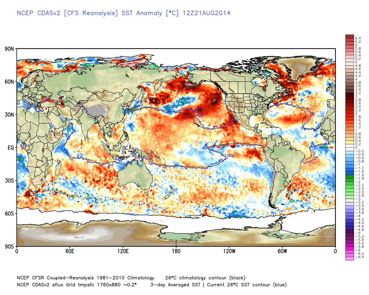
I broke down its Sea Surface Temperature Anomaly output for this month..

Few things to notice, the warmer than normal water in the NE Pacific, the warmer than normal water off the coast of South America (El Nino) and the warm, cold, then warm water over the Atlantic.

Warmer than normal water in the NE Pacific promotes a downstream Ridge of high pressure or rise in the jet stream as seen above, which results in a trough or colder than normal conditions over our area. The west based El Nino favors a active sub tropical jet which will bring alot of moisture into the country that can potentially merge with the northern jet (drawn in black above). And finally the Atlantic Tri-Pole promotes high pressure over Greenland which also supports a dip or trough in the jet stream over our area. 

Bottom line the Sea Temp projections favors this set up and it is one of the most important factors I will be watching before I release my winter forecast sometime between Oct 15th-25th. At that time I will break down all the factors I am looking at, many of which I am still following the trends on closely. 

Now here is an example of why you can't always just trust a temp run of any model..here where the temp projections from Oct of last year for this past winter on this model..


We all know that was not the final result. The point is its important to study factors that drive the overall upper air pattern which ultimately derives the temp patterns. If any of these factors unexpectedly change over the next two months it will drastically change the winter outlook. I can easily release one now but I want to be more patient to hopefully increase the accuracy. 

Thanks for checking in. 


Tuesday, September 23, 2014

Tuesday Night Special Weather Update: Rain Storm to Effect Area Thursday

A good day of rain is ahead of us on Thursday due to a coastal storm effecting our region. Details in the video below. 


Monday, September 22, 2014

Monday Morning: As Discussed Friday- Warm Weather Arrives This Week

A few cool fall days ahead, then the pattern changes as I discussed in my video Friday. By the end of the week temps will get into the 80's. I expect this pattern change to hold into the first few weeks of Oct.


Friday, September 19, 2014

Friday the 19th: Looking at October and Winter Factors

Video below discusses the weather pattern setting up for Oct along with updates on some winter factors. 


Monday, September 15, 2014

Monday Morning Weather Update

The fall temps have arrived and everyone felt it this morning with temps below 50 in some spots. This is due to a trough over our area, the same trough that brought snow to the western part of the country last week...

Typical setup for cooler than normal east, with a trough just off the pacific coast which pumps up the ridge on the west coast and a corresponding trough over our area. Notice as well the NAO is negative as shown by the red colors over Greenland.

This pattern will lock in for this week and have below normal temps over our area on the front 5 days. 


Temps will struggle to get into the mid-70's with this air mass, and lows at night will be very chilly.

As we get to the end of the week, things will moderate slightly but nothing to write home about..


I think September ends up very below avg for temps central part of country, above normal for the West and just slightly below normal temps for our area.

Enjoy the nice fall weather this week.

Monday, September 8, 2014

Monday September 8th: Fall Has Arrived

The heat has broken and we are now experiencing fall like conditions over our area. These conditions will continue into early next week where temperatures will struggle to break 80 on the hottest days. Looking ahead to this weekend, we can see some unsettled conditions with temps struggling to break 70! As I said fall is knocking on the door.

Here is the pattern change in terms of temps at 5,000ft relative to normal.

As you can see will be a big shot of polar air in the central US this week and this will bleed over to the east but moderate a little by this weekend..


As the air arrives it will bring along with it a front later this week which can bring some unsettled conditions Thursday night..

The real concern for rain, however, looks to be this weekend where low pressure will develop along this front and possibly have some tropical influence. This would mean a lot of rain for our area and not a pleasant weekend..


Before we write off the weekend lets wait and see how and if this evolves.

More later this week. 

Wednesday, September 3, 2014

Wednesday Weather Update

Good morning, very hot and humid conditions are upon us and it all due to a change in the upper air set up over our area.

Looking at the image above you can see the orange colors over our area which represents a ridge of high pressure. High pressure spins clockwise so it brings a southeastern flow off the tropical Atlantic into our area which causes the hot and humid conditions. As in many cases, the weather on the west coast is the opposite with a trough over that area as seen by the blue colors. 

I expect the above normal temps to continue through mid-month (not this hot, but marginally above average). This should not last for too long however, as the oceans support a return to the pattern we had most of the summer. 

We get some relief Sunday as a front swings through the area Sat night..


As I mentioned in the video on Winter last week, we will keep an eye on the ocean temp profiles this fall...


The water in the northeast Pacific is key. We need that to stay warm to support a cold winter. In two months we can make a more accurate assessment and evaluate other factors to determine the final result of Winter 2015.