WINTER OUTLOOK 2023 IS NOW LIVE

The 2023 Winter Outlook

Thursday, April 30, 2020

Thursday Weekend Outlook: Saturday is the Day

Good morning. Rain will settle in today and early tomorrow as a front needs to work its way through the area. Things will begin to clear by the weekend paving the way for an excellent Saturday. Things then return unsettled for Sunday.


A warm front is currently over our area bringing with it rounds of light showers...


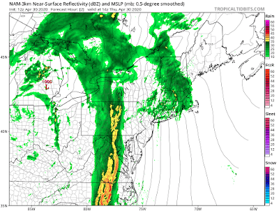
By later this afternoon that ugly cold looking front to the west moves through with heavy rain and a few storms...


After the front moves through, tomorrow will be mostly cloudy with unsettled conditions due to an upper level low still over the area seen below...


Things fully clear out by Satuday and at least a part of the day Sunday with sunny skies and temps in the upper 60s to 70...


Another cold front can move through Sunday afternoon causing showers to develop.

Thats all for now.

Tuesday, April 21, 2020

Tuesday: Storms This Afternoon, Very Cold Wednesday, Rainy End of Week

Good morning. A big cold front will approach the area this afternoon with strong thunderstorms. Some could be severe...

This means heavy rain and high winds in spots.

In the wake of these storms very very cold air moves in for this time of year...


Freeze warnings are in effect and temps drop into the high 20's to low 30's tonight for many. If this was February we would be in single digits!

Wednesday also stays cold with highs in upper 40s and lows in low 30s.

The cold air is due to this big blocking ridge out west over Alaska allowing air to pour in directly from the pole...


Things continue to stay active due to this winter like blocking pattern. More rain on the way Friday and potentially again Sat night into Sunday where a larger storm can hit.

Stay tuned. 

Thursday, April 16, 2020

Thursday Update: Snow for Some Tomorrow

Good afternoon. A colder than normal air mass has now entered the region. Temperatures stay chilly next two days with freezing temps at night for many. The big story will be accumulating snow that will fall from northern PA, to southern NY state into Mass, VT and NH. I expect up to 6" in the mountains.

Lets take a look...

Very cold air mass currently over our area...


Snow showers across the interior due to the arrival of this front and the instability associated with it...


By tomorrow an upper level disturbance riding along the frontal boundary will cause low pressure to develop and ride east into tomorrow night...


I like the placement of this model projection. Notice how the snow is confined to the interior until you get into Mass.  For the Berkshires, Catskills, and Green Mountains I can see this dropping 6".

For areas at lower elevations I would say a general 1-3" is a good bet up there.

Model snow maps are a little overdone for lower lying areas but got the mountains accurate imo...

You can see the model tries to show the mountains with higher amounts...


Again I think for areas like eastern Mass this is overdone. I do not think you are seeing 7 inches of snow.

I will check in tomorrow morning when this is underway.

Sunday, April 12, 2020

Easter Sunday: Impressive Storm System Down South Targets Area Tomorrow

Happy Easter!

Very severe weather down south currently due to a big clashing of air masses and deepening storm system developing. 

This moves towards our area tomorrow with rain and very very high winds. Guest of 40 to 50 mph inland with up to 70 mph for localized areas near coasts. More in video below...


Thursday, April 9, 2020

Friday: Major Winter Storm For Maine and Northern VT, NH

Good morning. A low pressure system is developing currently and getting ready to explode off the coast of Maine later this afternoon and tonight...


The pressure reading could go below 970mb with this system which is extremely strong. 

Heavy snows will fall especially in the mountains with amounts well over a foot including Northern VT and NH...


Would have been a great least season ski trip to Stowe or any of the mountains up there. 

Looking at the upper atmosphere we can see a strong upper level low that develops under blocking high pressure to the north.

Watch this this close off and explode as well as seen by the green...

The jet stream structure is just as impressive with a clearly defined northern and southern jet phase...


Things clear by this weekend (cold windy day Friday) and warm to the 60s by Sunday for NY  Metro.

We then have a shot of chilly air moving in middle of next week...


Its not winter so nothing crazy just widespread 50's and lows in 30s at night.

Thats all for now. 

Friday, April 3, 2020

Friday: Beautiful Storm Offshore, High Impacts New England Shore

Good morning. You may have noticed the last 24 hours high winds region wide. As the morning unfolds showers will also move through the area with storm conditions up in eastern New England.

This is all due to a very impressive storm that has been lingering offshore and retrograding to the west...


The storm has an eye like feature and is very strong. Currently it is battering the shores of eastern New England...


Some snow also fell and is falling in the Mtn. Peaks.

High winds really whip up today along the shoreline causing issues at the beaches...


This storm is stalled and moving west due to it being cut off from the jet stream via blocking high pressure (high pressure spins clockwise)...


Watch how the blocking high causes the storm to linger and move west then finally back out to sea as the jet stream catches it again...


This is a textbook closed off storm that forms when we have a -NAO pattern (high pressure over Greenland). If this was even closer to the coast mid winter we would be talking feet of snow. 

Mother nature can be quite impressive at times.

The weather clears out by the weekend.