WINTER OUTLOOK 2023 IS NOW LIVE

The 2023 Winter Outlook

Monday, June 25, 2018

Monday Weekly Weather Summary: A Nice Week Ahead, Major Heat to Follow

Good morning. It looks like we will have a nice week of summer weather on tap with moderate temperatures and mostly clear conditions.

The only shot for rain appears to be some showers and storms Wednesday night and Thursday as a frontal system will be moving through the area...


As we enter the weekend the headline will the heat. Starting Saturday, a larger upper level ridge starts to form over the area...

This ridge continues to build into early next week..


Now this has the chance to be record breaking. There are some crazy model projections out there right now for how hot it can get early next week..


Keep in mind  this can be overdone. Regardless, you can see triple digit heat is possible next week through the 4th of July.

I will have  a follow up post on this later this week.

Friday, June 22, 2018

Weekend Update: Some Unsettled Weather

Good morning. It looks like we will now how to deal with some rain Saturday as a storm system moves through the area. I am unable to upload pictures this morning due to website issues but here is what to expect.

Showers will move into tomorrow morning with mostly cloudy skies. By the afternoon the sun can poke out a little but there will still be the threat for showers and storms as we enter the evening hours.  Temperatures will stay in the 70's.

On Sunday another upper level disturbance can cause some more showers and storms but I expect a little more sunshine with warmer temperatures in the 80s.

So overall not the worst weekend but we definitely will have some rain to deal with.  Saturday afternoon can be ok in spots with Sunday the better day overall.


Tuesday, June 19, 2018

Tuesday Weekly Weather Summary: Heat Breaks

Good morning. Yesterday (Monday) was the hottest day of the year for many and the humidity really cranked up too. I think it reminded us all to be careful what we wish for. It may have been a cooler spring but once that humidity cranks up it isn't so pleasant.

Today will feature temperatures in the mid to upper 80's but relief comes in later as a cold front enters the area taking the humidity out of the air as seen by the lower dew points...

By Wednesday and Thursday temperatures will drop to lower 80's and things will become quite pleasant. 

There is the shot that a disturbance moves along a frontal boundary Wednesday night into possibly Thursday morning causing some showers and storms...

A cool Canadian high pressure system then moves in Friday and will result in a very pleasant and cooler weekend. Expect temperatures in the upper 70's Friday and lower 70's Saturday....

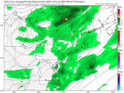
We then may see another system effect the area Sunday morning with some showers, but things do look to clear for Sunday afternoon...

From here we then should enter a typical summer pattern with a mix of warmer than normal and average temperature days. 

Enjoy the week.

Tuesday, June 12, 2018

Tuesday Weekly Weather Summary: Calm and Pleasant

Good morning. Not much to say for this week. Temperatures have been on the tame side all spring/early summer and that will continue next several days.

The only chance for some showers at this time is Wednesday afternoon as a weak front moves into the area...


High pressure then returns to the region for the weekend...

This means pleasant temperatures in the high 70s to low 80s with very little humidity.

Some heat will try to build by early next week as a ridge moves into the area...

However, as the theme has been going all season this does not look to last and cooler air returns for the end of next week and beyond. You can see this by a ridge of HP over the west and trough of low pressure/cooler air in the east...

Considering I hate hot and humid weather I am not complaining.  So far I have not used my AC all summer. Lets see how long the streak continues.

Monday, June 4, 2018

Monday Weekly Weather Summary: Cooler But Ok Overall

Good morning. As we now have entered June, many have been wondering where is summer? The last several weeks have featured a lot of unsettled weather along with frequent rain. As we head into this week, it will be a little more of the same but not as wet.

The highlight of this week will be the cooler than normal temperatures. Temperatures will be in the 70's and maybe even high 60's on Wednesday. This is due to cold Canadian air flowing into the region.

Today will clear up nicely with temperatures in the 70's.

Tuesday also looks to be a decent day with partly cloudy skies and a chance a an isolated shower or storm later in the day..

As we enter Wednesday, a cool Canadian high pressure system moves in which will clear up the skies but cause temperatures to drop below normal..

This is where many areas, especially up in New England will see highs in the 60's.

The rest of the week then stays tame with temperatures climbing slightly but still staying in the 70's with mostly sunny skies.

For the weekend, we need to watch out for showers and storms as a warm front will try to move up into the area. The question then becomes will a low pressure system try to form along this front causing rain issues for Sunday.

Right now the models are showing something can happen later on Sunday...

Before that however, it does look like the weekend can be spared with maybe just the chance at some afternoon showers and storms Saturday afternoon.

Overall not a bad week just cooler than normal. As the next few weeks progress, it looks like a continuation of this cooler than normal and unsettled pattern continues. As we enter late June and July, a normal summer pattern should take hold which should eliminate the chances of any rainstorms. Instead, we will see the normal pattern of afternoon showers and storms at times. Regardless, I do not see any big heatwaves on the horizon.