So how do things look? Well, I am not too concerned about shots of cold air filtering into the region as there is a lot of support for that on the models over the next month. I also am not concerned about storm activity as many storms will move through the country. However, the million dollar question is will these two factors come together properly to cause more snow than rain for the northeast. My confidence is still high for New England in that regard. For the Mid-Atlantic, we need to wait and see.
Lets take a look at next 2 weeks....
Rain moves through today and tomorrow with milder temps..
In the wake of this storm system cold air then follows as we end the week through early next week...
We then enter a very interesting period. With this cold air in place there is the chance a storm system develops early next week. The European is the most aggressive with the storm development...
The European cuts a storm system to our west but has just enough high pressure up in Canada filtering in cold air to possibly result in a heavy snowfall for interior New England Monday and Tuesday. Rain for other areas in this scenario.
The GFS is nothing like the European and has nothing...
The reason for the big difference is the upper atmosphere. The European model consolidates energy ejecting from the southwest while the GFS does not. The image below shows the stark difference in the upper atmosphere....European left, GFS right. Notice how the GFS has a ridge of high pressure where the European has the storm system.
What does all this mean?
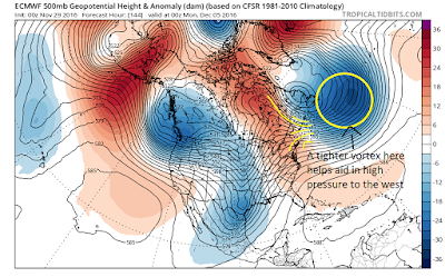
It means the models are struggling to handle the weather pattern in transition. There will be a storm next week its just a matter of when and where. It will all come down to the strength of the hp in Canada and if it can be held in place. A big factor in this is the strength of the low pressure system off the coast of eastern Canada. The stronger this is the more likely it is to lock in high pressure. I drew a diagram below....
This image from the European shows a stronger vortex than the gfs in this location. This causes more air to come together where I drew the yellow lines. At the surface this causes stronger high pressure which locks in all that cold air ahead of the storm.
The GFS model has this vortex more diluted and less organized. Thus, it has the high pressure weaker.
Pretty complicated stuff but overall this is nothing more than models trying to sort out the weather pattern. Regardless of if its mostly rain or New England snows next week..cold air again follows as we move through mid Dec...
When this is all said and done we might have to see a little more rain before we see snow but by week 2-3 of December the winter season should really start to take over. It is at this time that the Mid-Atlantic should star to get into the mix with winter weather.
If that does not happen then well we might have to reevaluate what is going on. No one wants shots of rain followed by cold. Lets not jump to that conclusion at this time.
More later this week.


