WINTER OUTLOOK 2023 IS NOW LIVE

The 2023 Winter Outlook

Monday, October 31, 2016

Monday Morning Discussion: A Brief Warm up Followed by Major Pattern Change

Happy Halloween! As November knocks on our doorstep, the next two weeks will really remind us that we are in a season of transition in our weather pattern. Temperatures will gradually rise this week peaking in the low 70's Wednesday and Thursday. As the weekend approaches, temperatures will fall again back into the 50's as northern high pressure returns. As we have been discussing, heading into the 2nd week of November and beyond we will be faced with a significant pattern change. This means colder than normal conditions are likely from the 2nd week of November and beyond. 

This post might get a little detailed. I will also be cutting a video this week to break it down in a more understandable fashion. 

 Lets take a look..

All maps below show areas of high and low pressure/warm and cold air. This also represents the positioning of the jet stream. Remember the jet stream acts as a barrier between warm and cold air so as it rises warm air raises with it and as it dips cold air filters down from the north.

Starting this week, you can see a high pressure ridge builds over the east. This gives us the warm temperatures Wednesday and Thursday..


As we enter the weekend a pesky little trough of low pressure dip down into the northeast. This kills the heat and brings things back on the chilly side. Notice the central US stays very warm but that sharp amplitude of the jet in the central states along with the riding over Greenland (negative NAO pattern) causes this dip over the east. 


As we enter week two, things really start to transition. The ridge begins to pull to the west which will open the floodgates for shots of cold air to filter into the eastern 1/3..


In the longer range this pattern only amplifies with a trough south of Alaska, big ridge out west, trough in the east and ridge over Greenland. I marked all these features to make it easy to understand. Bottom line, this pattern means business! I expect everyone to notice the changes as we hit week 2...

You can see all the features labeled above as we hit the long range. This is merely an ensemble mean meaning it averages many different model members as to where the areas of high and low pressure will be. Since it is an average, the images gets diluted at times as some members might have a trough where there is a ridge vice versa. Every major model is showing this pattern however. If you also couple this with the weak polar vortex we have been observing, the cards are  aligning for a very wild period in the long range. 

Currently the polar vortex is ALMOST in a split pattern. This is very rare for this time of year. There is a delayed response from what happens up in the stratosphere, from the vortex splitting, to its effects on the troposphere. That delay is usually 2-3 weeks. Currently we have a vortex that is split (unbelievable)...


Extremely impressive! Why? Because a split vortex means a weak vortex. When the PV is weak cold air can filter down from the upper latitudes. When it is strong, the cold air stays locked north.  As the weeks go on, the models project that this vortex stays weak and off of its axis as seen below. This also is critical as its positioning will influence our long term pattern. In image below notice the vortex is off to the right of the pole in week two...


This can have big implications in locking in a cold pattern if verified. 

Bottom line: Buckle up, we have a period of wild weather on tap from week 2 of November and beyond. 

I will have a video on all of this this week as it can get complicated to explain over a text post. 

Thursday, October 27, 2016

Thursday Morning Note

Current radar shows a decent idea of precipitation type as it matches many of the observations I have been looking at..


Snow to the north some light freezing rain to the south where you see the pink. 


Next week we get a very nice warm up. Temps can reach the 70's in spots!


However, as I have been talking about all signs point to a very cold November from the 2nd week of November on. The models are still supporting this. Due to that unprecedented split in the polar vortex, we will see how this really plays out (a weakening polar vortex is a major wild card). Will November be more like December? We will have to wait a little longer to see.

By around the 6-10th the models really start to show a massive ridge crank along the west coast..


How quickly this evolves is up for debate as some models are slower than others. They all eventually show this..


I am very confident in the high latitude blocking to support this pattern. At this time the only thing that would flip this is if the pacific jet g0t too strong and it overpowered the pattern. That can happen but that is not my forecast at this time.

More in days to come. 

Wednesday, October 26, 2016

Wednesday Morning: Flake or Two Possible Extreme NW NJ, Otherwise Rain

Keep in mine we are really splitting hairs here as it is mainly going to rain tomorrow. However, for you snow nuts out there who might need their fix, it is possible that a few flakes fly NW of interstate 80 at the higher elevations tonight before a quick changeover to liquid. No accumulation expected. 

A potent upper level short wave and its associated low pressure system approach the region tonight..


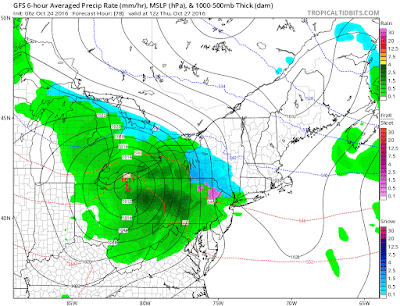
You can see below the GFS model vailid at 8 am. I drew out what is going on. We have a departing area of high pressure (giving us the current cold air) and an approaching low that is bringing with it warm air. Initially (only for a few hours) the cold air tries to dam or hold on in areas of NW NJ, Northern PA, and southern NY state. This means AT ELEVATIONS OVER 800FT some flakes can fly for a short period of time. 

Up in the mountains of New England this looks to stay mostly snow in the mountains.

You can see by mid morning tomorrow it is rain everywhere except ski areas up north...


This is just one model projection but I have looked at all of them and I think the GFS model has the right idea here. 

Moving into Halloween weekend, temps do stay on the chilly side before warming up by next week into the 60's. 

After the 1st week of November the cold returns and it might be with a vengeance. Stay tuned for that evolution. 

Tuesday, October 25, 2016

Lets Keep an Eye on Tomorrow Night

Nothing serious, but higher elevation/northwestern counties of NJ, and the Pocono region might see a few flakes fly just after midnight. Maybe a dusting in some spots then a quick change over to ice then plain rain. I will do a write up on this tomorrow morning.

Monday, October 24, 2016

Monday Morning Weather Discussion: Winter Knocking on Our Door

Good morning, I hope everyone enjoyed my winter outlook. We are going to stay on a similar theme today as the weather pattern has really come alive in recent days and shows more signs of life in the coming weeks. The mountains of New England got their first snowfall of the season over the weekend with areas like Jay Peak, VT receiving a foot plus of snow! Believe it or not, more snow is on the way to the mountain areas later this week as a potent clipper system move through the area. 

Here is a summary:


  • Cold air enters region today through Wednesday. High temps will struggle to get into the high 50's for many spots with lows approaching freezing in northwest counties.
  • A potent clipper system enters on the heals of this cold air causing some snow to break out initially in north central PA and southern NY State. The mountains of New England get another moderate snowfall from this.
  • Moving to the long range, all signs point to a cooler than normal November
  • This is supported by a very early season warming of the stratosphere that is about to occur. 


To set the stage, cold air builds back into the region today through Wednesday with Wednesday being the coldest. Expect temperatures to be in the 50's in most spots and possibly not breach 50 in northwestern counties on Wednesday. The image below shows this injection of air from the north..


Notice the arrows coming down from the north showing a north to northwest flow of cold air into the whole area. On the heals of this cold air mass, we have a low pressure system (clipper) that is going to approach from the west on Wednesday night and Thursday. The initial burst of precipitation can be snow for areas of north central PA and southern NY State. Northwest NJ might squeeze out a flake or two but I am not sold on that idea yet. The mountains of New England receive another moderate snowfall from this.

You can see the initial projections of precip on the GFS model..


Model is showing how cold air tries to hang in there initially. As the cold air departs the southern zones, the focus then becomes the mountains..


We will have to keep a close eye on the dynamics between how long the cold air holds on vs the strength of this system. If this system ends up being modeled a little deeper than cold air can hold on longer.

In any event, here is an idea of snowfall. Just focus on the spotty areas as I do not expect much of any accumulation outside of the mountains. I do not think that the low level terrain sees accumulations at this point. The model is prob overdoing those areas. 


In any event, we can all see winter is around the corner. This brings me to my next point..the stratosphere.

We are currently about to witness a very rare event in the stratosphere for this time of year. Models are projecting a stratospheric warming event which will largely displace or even split the polar vortex over the next week or so. I can not emphasize how rare it is to see that happen so early and I believe it will have big impacts on our weather from mid November on (2 to 3 week lag in response in the troposphere).

To make a long story short, when the stratosphere or upper levels of the atmosphere warm, it puts stress on the polar vortex. This stress weakens the polar vortex which allows cold air to spill into lower latitudes. On the flip side, when the polar vortex is strong the cold air stays locked up north. Looking below we can see what the GFS model is showing way way up in the atmosphere (much higher than planes fly)..


This shows temperature/pressure patterns. Notice the area of warm invading the poll and causing the vortex to almost split into two separate lobes. We usually do not see this happen until January or Feb or sometimes does not happen at all depending on the winter. What does it mean? Well, if we in fact do get the vortex to come under this stress then attacks of arctic air will be frequent from mid November on. 

Really interesting stuff. 

The models are starting to hint at this as well as we enter November..


Remember it is not January of February so a cold outbreak is not as intense. However, I think this November will be much different than last year in terms of temps and storminess. 

Thanks for reading. 


Wednesday, October 19, 2016

WEATHER WILLY'S 2017 WINTER OUTLOOK

The video below gives the details behind my 2017 Winter Forecast. This is for those of you who are interested in the forecasting techniques. Enjoy!


<<<<<<<<<<<<<<<<<<

Original Simplified Text Version


Welcome to the long awaited 2017 Winter Outlook! So what will this winter bring? That always is the million dollar question and often times only mother natures knows the answer. However, a forecaster has to try to make their best calculated estimated on what will occur based on observations, history and long range weather models. Those are the three components that go into developing my forecast. Starting the summer months I begin to observe what is going on in the atmosphere. I then take a look at how these observations might evolved based on history and model projections. As we enter the fall months, I can start to observe in real time how the atmosphere is behaving, find historical years where it has behaved similar, then compare with what the long range models show for the winter season. 

THE BOTTOM LINE:


Temperatures:


Snowfall:


Highlights

Pacific Northwest:

  • Colder than normal temperatures with rounds of heavy mountain snows due to an active pacific jet stream
New England:
  • A very cold and stormy winter. It will snow frequently this year, especially in the mountain areas. This should make for a banner ski season with well above normal snowfall. 
  • 3 major storms (12+ inches)
Mid Atlantic:
  • I expect an active back and forth winter in this region. Temperatures will be chilly but I do not expect a brutally cold winter. 
  • There will be a lot of storm activity but it will not all be snow. Expect everything ranging from rain events to ice and snow. 
  • For the northern Mid-Atlantic (light blue area) expect frequent wintery precipitation which should average out to just above normal snowfall. 
  • For areas a little further south including Philadelphia and Baltimore/Washington expect average snowfall amounts due to ice and rain cutting down on seasonal accumulations.
  • 1-2 major storms (10+ inches) can be expected in the light blue zone.
Southern States:
  • Not much in the way of snowfall. Chilly at times but your standard run of the mill winter with cold shots followed by spells of warmer than normal weather. 
Ohio Valley/Great Lakes Regions:
  • Very cold for the northern areas in this region (Great Lakes) and slightly colder than normal for the southern areas (Ohio Valley)
  • Above average snowfall due to the frequency of storm systems passing by ( light to moderate snow events)
  • 1 major storm
Western Ski Areas:
  • Decent ski season overall for central and northern Rockies 
  • Some areas more on the southern end of the Rockies might see below normal snowfall due to persistent ridges of high pressure keeping the storm tracks more to the north. 

So as you can see I am predicting an overall very decent coast to coast winter! Skiers should be looking forward to 2017 whether you are planing to head out west or head up into New England. 


Monday, October 17, 2016

Winter Outlook Out Wednesday

No post today, Winter Outlook will be out on Wednesday at 8am. Stay tuned!

Tuesday, October 11, 2016

Tuesday Morning: Cold Shot in the Long Range?

*WINTER OUTLOOK 2017 WILL BE RELEASED WEDNESDAY OCTOBER 19TH*


Good morning, quick post today on the long range. For the last few cycles, the weather models have been indicating the possibility of a decent cold shot towards the end of next week. Now anytime we are over a week away, it is very hard to know the exact details. We can however look for hints and imagine how models may trend towards an idea.


Lets take the European ensemble for example. Here is its projection for late next week..


This is an average of many different ensemble member outputs but it shows you what the model is hinting at. For one, we have a deepening trough or area of low pressure south of the Aleutian islands. The normal response to this is a ridge of high pressure in the west and a trough in the east. This trough means cold air would be able to funnel south into the central and eventually eastern states at the end of the 14 day period.

The GFS ensemble is hinting at the same thing..


We will see how this turns out. 

Friday, October 7, 2016

Friday Morning Hurricane Update: Major Bullet Dodged, Matthew Stays Just Offshore

WINTER FORECAST 2017 WILL BE RELEASED ON WED OCT 19TH


Good morning everyone. Well, the real time track of Matthew is now in and it is good news. Yes the forecasts where all wrong including my own about the major impacts this storm would have but in this case that is wonderful news. Shows you how when a forecast literally comes down to 40 miles computers are in many cases useless! The issue is if a forecaster then downplays the storm and they are wrong, the end result is ten times worse than if they err on the side of caution. There is no better example than Hurricane Matthew which has winds of over 120 mph literally miles off the Florida coast. 

So here is the current storm..


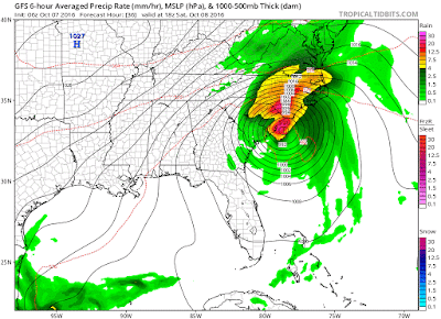
You can see the eye wall circled in red. This is where the most intense destructive winds are in a hurricane. This literally is going to say just 40 miles offshore. The difference of this is huge! 40 more miles west and we have a big natural disaster. Models sometimes cannot handle details that small just like in the winter when we are trying to nail down a rain snow line!

In any event, 100% of forecasts were wrong. The problem is it would have been foolish for anyone to downplay this and be on the wrong side of the bet. Unlike the winter where it is rain vs snow, this is life vs death.

The National Hurricane Center has adjusted their track..


Winds will still be gusting up to hurricane force in places. The rainfall will also be an issue. Here is projected rain through this weekend..


Yellow colors are up to 10 inches. That will cause impacts in verified. 

You can see how this storm just bends up southern coast..


No impacts north of the Carolina's.

Thanks all for now.  

Thursday, October 6, 2016

Special Video Update: Hurricane Matthew About to Wreak Havoc

Special Prime Time Hurricane Update 9pm

Stay tuned for video

Thursday Hurricane Update:Matthew Makes Bee-line For Florida

*WINTER OUTLOOK 2017 WILL BE  RELEASED ON WEDNESDAY OCTOBER 19TH*


Good morning. It is now becoming likely Matthew hits the east coast of Florida as a Cat 3 hurricane early tomorrow. Most model guidance brings the eye close enough to shore to cause big issues along the eastern coast. The storm will then scrape its way up towards the coast of Georgia and South Carolina likely weakening to a cat 1 before curving and lingering out to sea. 

This looks to be an historical event for down there and I do not say that in a good way. I have concerns that we will see damage. 

Lets take a look at the storm currently..


You can see how the eye is reforming  and it is now over the Bahama Islands. Current wind speeds are at 115mph gusting over 140 mph! 

Models are all taking this in striking distance of Florida..


National Hurricane Center has put coast on high alert for Major Hurricane..


Looking at the wind projections and tracks of a few models you can see how bad this could be..

HWRF Model,,


GFS..


The European looks similar to both of these with projected winds! FYI the light purple and pink colors are winds over 100 mph.

The storm then works its way up to Georgia and the Carolina's Sat and Sunday..


It remains to be seen how much strength this storm has by the time we get to this point. It will all depend on how much land Matthew interacts with. Regardless, a Cat 1 is very possible for these areas which also would bring with it impacts. We will hone in on this more tomorrow.

Heavy rainfall will also be an issues as seen below..


Lets hope this stays just offshore and doesn't make a direct impact. We are talking about a margin of error here of 50 miles! That means this is just a wait and see!

More later tonight around 8pm as this storm approaches Florida. Stay tuned. 

Wednesday, October 5, 2016

Wednesday Morning Hurricane Update: Escape Route Open for Northeast, FL on High Alert

  
Good morning everyone. More major changes over the last 24 hours. It now is becoming clear that the original out to sea scenerio I was favoring Monday is back to gaining ground. At this time yesterday, we saw a big trend towards a storm that effected the whole east coast- now its the opposite. Do not be surprised. As I have mentioned, anytime you are over 100 hours out on weather models major shifts can and will occur. We will keep this in mind when we track winter storms.

So here is updated summary:


  • Hurricane Matthew now stationed just north of Hatti is still a very powerful storm
  • Over the past 24 hrs models have shifted to Matthew impacting Florida, Georgia, and South Carolina then curving out to sea
  • I now assign a 70% probability to this storm going to sea and 30% to it coming north. 
  • When it is all said and done, the eastern shores of Florida and Georgia can expect high winds and heavy rain Friday and Saturday
    • Worst impacts will be in Florida. 
Here is a current satalite view of Matthew..


Here is the updated spread of models. Notice the major shift out to sea from yesterday..


The National Hurricane Center also has adjusted..


We now need to turn our focus to Florida as this storm will come very close to making direct landfall..


Image below shows the storm just off the coast of FL Friday. Notice the strong wind field. We need to track very closely this hurrucane force wind field as it gets close to the coast line. Although it appears this can scrape on by, it is way to close for comfort and still will have big impacts Friday and Saturday.

The storm will then work its way off the coast of Georgia Saturday. Heavy rain, wind and high surf can be expected. Again we still need to nail down the exact details..


When it is all said and done, here is an idea of total rainfall...


Notice the sharp cutoff. We will see how close this gets.

So why the big shift from yesterday? I explain in image below..


That trough approaching from the mid west we have been talking about is much weaker on updated models. Because of this, the storm does not interact with it and instead gets squashed by high pressure to the north.

Just another example of how models can change drastically days away from an event.

That's all for now. Thanks for reading.

Tuesday, October 4, 2016

Hurricane Matthew Update: Westward Trend Emerges, Going to Be a Close Call

  
    *WINTER OUTLOOK 2017 WILL BE RELEASED ON WEDNESDAY OCTOBER 19TH*


Good morning. Lets dive right into it. Over the last 24 hours there have been some significant trends to bring this storm more west up the coast this weekend. Although this scenario is still not by any means set in stone I need to now assign it a higher probability than I did yesterday. The main impacts of an east coast hit would mainly be very heavy rain and gusty winds as this would become a post tropical cyclone once it merges with an approaching trough. 

Here is a summary:

  • Hurricane Matthew is currently a very powerful Cat 4 hurricane making landfall in Haiti.
    • Winds are gusting over 150 mph and there unfortunatly will be horrible impacts for that country 
  • Models over last 24 hours have indicated this storm could sweep up the east coast as opposed to curving out to sea
  • At this time I assign this a 50% probability 
  • Impacts would be felt on Saturday and Sunday with heavy rain and gusty winds
  • Much can change and I still give this equal chances of just missing our area out to sea

So lets start by looking at this monster on satellite..


Extremely destructive storm and you can see above how it is making landfall in Haiti. 

From here models are now tighter in their projection of this storm moving closer to the east coast..

This spread is much narrower than yesterday which had many more projections more out to sea. 

At the surface here is the updated GFS (left), Canadian (right), and European (bottom) models for this weekend..


Take this with a grain of salt for now. We still have over 100 hours to go. A lot can change including this trending back out to sea. Regardless, a big shift west from 24 hours ago.

You can see how if we look up to 18k feet in the atmosphere the European made a big shift (click to make bigger)..


The new run of the European model in the right image shows a much stronger trough approaching in the mid west compared to yesterday. Also, notice more red (high pressure) in the Atlantic which helps slow this storm down. 

So as you can see we have to watch this situation extremely closely. I expect there to be more changes in the models especially in next 48 hours. For those of you who have weekend plans, I would not cancel anything yet but would be on high alert. I think by Thursday we will have a good grip on this situation. Lets see how this trends over next 24 hours.

More to come. 

Monday, October 3, 2016

Monday Morning Weather Discussion: Update on Hurricane Matthew

*WINTER OUTLOOK 2017 WILL BE RELEASED ON WEDNESDAY OCTOBER 19TH*


Good morning everyone. As Hurricane Matthew rages in the tropics I wanted to give my updated thoughts on how this storm will evolve. At this time I am not expecting any east coast landfall. I will explain why in the post below. To start, here is a summary of my thoughts:

  • Hurricane Matthew is currently a Cat 4 hurricane with winds of 130 mph
  • It is located in the tropics just south of Cuba moving north
  • Models continue to take this storm north over the next few days then start to diverge on where it ends up by this weekend
    • Some take it out to sea other make it more of a threat to the east coast
  • At this time I am favoring the out of sea track with limited impacts.
  • If there are any impacts they will be this weekend

Lets start off by looking at the current storm..


You can see a clearly defined eye and the speculated track by the national hurricane center to the right. This goes along with current hurricane models..


Looking at the major operational models we have quite the spread of what can occur. The image below shows what these models are showing at the surface for this weekend..


Top left GFS, top right is Canadian, and bottom is European model. Notice how the GFS is the most aggressive with this storm. It has it plowing up the east coast with very heavy rain and wind Saturday and Sunday. The Canadian model keeps most impacts off shore and the European is way out to sea.

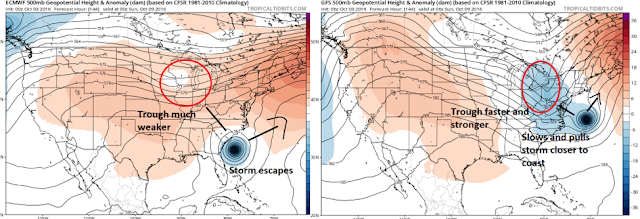
So whats my take? Well first lets take a quick look at why the GFS is so aggressive. As usual it comes down to the atmospheric set up at 18,000ft...


Left is the European upper air pattern and the right is the GFS. I want you to focus on the white and blue colors in the vicinity of the mid west. This represents a trough approaching the area. Notice on the European (left) this trough is much weaker and slower than the GFS (right). The faster stronger trough in the GFS projection interacts with the storm and pulls it closer to the coast. That is why at the surface you see such a drastically different outcome. 

Do I buy it? No not at this time. Despite the fact the GFS has been very consistent with this idea for days now, it simply does not have much model or ensemble support (except for its own). Most other guidance supports the European idea of a flatter slower trough and allows this storm to stay far enough offshore to not be a major threat. The Canadian model right now I think represents the best compromise. 

Like always  this is days away which means there will be surprises and changes. Thus, we can not rule out the GFS scenario. It just is not my forecast at this time.

More updates to come this week!