WINTER OUTLOOK 2023 IS NOW LIVE

The 2023 Winter Outlook

Tuesday, June 30, 2015

Tuesday Morning: Taking a Look at this Week Through the Holiday Weekend

A tricky forecast is in store for the next five days, especially as we head towards the 4th of July. This is all due to the overall synoptic (large scale) pattern that will be in place over the region this week. Looking below you can see a pattern that is charactorized by a western ridge and eastern trough. If this looks like a pattern that is more common in the winter you are correct! In fact, that is why you are seeing temps on the cooler side as the trough over the east brings in cooler air from Canada. 


What this pattern is going to end up being responsible for is multiple upper level disturbances and front crossing through the area. This is what is going to make the forecast difficult. Every model will handle each disturbance differently especially as we get closer to the weekend so the solutions could range from a Sunny 4th to a rainy 4th. At this time I am not calling for rain on the weekend, but acknowledge it could be possible. That is why I will have to have antoher update as the weekend closes in. 

First lets focus on today into tonight as a warm front will cross into the area...


This will give us a chance at showers tonight into tomorrow morning but then should clear for the bulk of the day Wednesday. 

The weather systems corresponding cold front then crosses through Wednesday night but there will be limited shower activity at that time. 

The very difficult part of this forcast comes as that frontal boundry stalls just to our south late in the week. Anytime you have a stalled front, it acts as a boundry between warmer and colder air. This can cause unsettled weather when you get upper level disturbances that spin up this warm and cold air creating precipitation. The problem is every model is handleing this differently. For example lets look at the Canadian..


It models the upper level disturbances will interact with the front and bring rain into the area for Friday and Saturday. In fact, you can see it has two low pressure centers forming as a result of this.

The GFS on the other hand keeps this all to the south..


Again this all will depend on where and how the upper level energy enters the pattern. As an example you can see how in the Canadian example it is modeling a strong wave of upper level energy as seen by the deep yellows and reds near the area..

The GFS much flatter, thus not as wet at the surface..


And there you have it guys, the 4th of July weekend's fate rests on what model ends up being correct! Stay tuned I will update on this as we get closer to Thursday.

Friday, June 26, 2015

Weekend Update: Rain,Rain and More Rain

The rain is going to move in very late tonight/early Saturday morning. as a low pressure develops along a front over our area. The image below is valid for Saturday..


By the time we get to Sunday morning there should still be some lingering showers with heavy rain to the north..


This storm should exit Sunday morning so as the day goes on the weather should improve. I don't expect sunshine but the main rain threat is Saturday.

Total rainfall amounts..

Thats all for now, stay dry!

Thursday, June 25, 2015

Thursday Weather Note

Good morning everyone. We have a big pattern change that is going to take shape this weekend and last through at least next week. What this means is we will see peroids of rain tonight into Friday morning. Then again on Saturday and Sunday. In fact the whole weekend could be a washout. After this unsettled weather moves through we are going to be in a period of temperatures cooler than normal all of next week. That means low to mid 70's!

I am going to have more detail on this in my weekend weather update which will be out by tomorrow morning. Before then, I will leave you with this..


Image above shows the pattern change with a big ridge of high pressure out west and a trough now in the east valid Monday. Heck we even have a nice negative NAO with the high pressure over Greenland. If only this was winter!

More later. 

Tuesday, June 23, 2015

*Strong to Severe Thunderstorms to Effect Area this Afternoon*

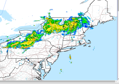
Good morning everyone. It looks like we just might still have the dynamics in place for some pretty big storms as we head into this afternoon. As you walk outside today you will notice how hot and humid it is. Heat index values will reach the mid to high 90's in spots ahead of an approaching cold front that will cause these storms to fire up. Below you can see the current radar scan that shows our area of storms out in PA..


This actually is ahead of the cold front and the timing of this complex vs the crossing of the front will determine how severe the storms get. Regardless, I see enough evidence in place to say SOME areas will see severe storms.

Instability values as projected by all the models still look decent. As a reminder instability measures the temperature of an air parcel compared to its surrounding environment. You want that daytime heating to warm things up and cause that air to rise..

Here is the updated projected instability..


Not every model is showing the same degree of instability but I like I said above I think there is enough evidence to support strong to severe storms. I am not on the bandwagon of an all out severe weather outbreak (more widespread) however. 

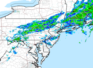
If we now go to the updated radar projections some pretty nasty storms are popping up this afternoon..


At this point it all will come down to nowcasting. We need to see where the big storm cells develop and what areas they will effect. I think the biggest threat for areas that get hit by the bigger storms will be very strong wind gusts, downpours and some small hail. In terms of tornado development it is not off the table but I do not see widespread support for that. 

 I will be having updates on twitter today with that information. 

Monday, June 22, 2015

Monday Morning Weather Discussion: A Hot Humid Start to the Week, Severe Weather Possible Tuesday

Good morning everyone. I will start by saying the weekend forecast was a disaster. For one it did not rain as much as expected and the timing was completely off.  Models significantly overestimated the rainfall amounts. The good news was that Sunday ended up being an excellent day unexpectedly.

The news this week will be the very hot and humid conditions  along with a potential severe thunderstorm threat tomorrow. By the time we get to the end of the week things will cool down a little but we can see some more showers Friday.

Lets look at tomorrows thunderstorm set up. You can see below the temperatures ahead of an approaching cold front..


This hot moisture filled air is going to be ingredient #1 as a cold front then comes approaching from the west. On the next image below you can see the high resolution NAM model's projection of storms popping up along the front..


Notice the low pressure system up in Quebec. That is what the cold front is associated with. 

To determine how severe a thunderstorm event may be, we need to look at how unstable the atmosphere will be. In other words what is the temperate of an air parcel compared to its surrounding environment. If it is much warmer than the environment then it rises causing those big storm clouds building high up in the atmosphere. We can determine the potential for this by using an index called CAPE. Below shows the instability for tomorrow afternoon. Just know the closer to red the more unstable the atmosphere is..


Could this be one of the bigger severe weather event for the east coast this year? I am not sure yet but it is work monitoring and I will have another update on this tonight or tomorrow morning.

Thanks for checking in. 

Friday, June 19, 2015

Weekend Weather Update: Beautiful Weather Gives Way to Father's Day Washout

Good afternoon everyone. I hope everyone enjoyed the week. The good news is tonight though tomorrow are going to be excellent. High pressure builds Saturday bringing mostly sunny and dry conditions. The problem arrises on Sunday however as the remains of Tropical Storm Bill come into the area. You can see the remains of Bill now in the center of the country today..


This is packing quite the punch in terms of rainfall and it will do the same here Sunday. Prior to that, here is the high pressure in control for tomorrow..


Expect highs in the mid 70's with no shot at rain until the nighttime. 

Now on to Fathers Day..


The image above is valid for Sunday morning, so any golf plans are not going to work out well.

You can see the impressive totals for rain projected by the GFS model..


1-2 inches and locally 3 can be expected from this storm. A lot looks like it occurs earlier rather than later Sunday.

Thanks for checking in guys. 


Tuesday, June 16, 2015

Tuesday Morning Weather Update: An Up and Down Week Ahead

Good morning everyone. We have a mix of everything coming our way this week ranging from more showers with humid conditions to cooler drier weather. More showers today, then high pressure builds in tomorrow, another front comes in Thursday night and again on Sunday of this week. Lets take a look..

We have more shots at showers and a storm or two today then high pressure builds in tomorrow..

Expect cooler drier conditions with temps in the high 70's and low 80's Wednesday.

As we get into Thursday afternoon a warm front heads into the area. This will bring the warmer humid conditions back over the area and cause some isolated showers. I don't expect a washout Thursday.


Its corresponding cold front then moves in on Thursday night. Thursday night into Friday morning is when we can see some more widespread showers and a few storms.

 Once we get to Friday, things should clear up again with high pressure back in control. This nice break in the weather should last until Sunday. Expect highs in the high 70's and low 80's with Sunshine on Friday and Saturday. 

The next round of unsettled showers and storms then arrives Sunday. 

Wednesday, June 10, 2015

Special Post on El Nino: Its Cause and its Effects on Our Climate

Welcome to my special post on what is know as “El Nino”. The goal of this post is to give everyone a general idea of what this weather pattern is and how it affects the climate. I will try not to get too detailed and keep things as simple as possible.

 In reality “El Nino” is a phase of a weather pattern called ENSO which stands for El Nino Southern Oscillation.  In a general sense this is an index that measures the water temperature profile off the west coast of South America. When water temperatures are warmer than normal (0.5 and above) it is an El Nino and when they are cooler than normal (-0.5 and below) it is called a La Nina. Today’s post will just focus on the warm phase or El Nino since it is relevant to the current state of our atmosphere. Below is a diagram showing this ENSO region..


esrl.noaa.gov


Do not worry about the different sub areas as that is a topic for another day. So let’s focus now on what causes this area to develop warmer than normal ocean temps. It all has to do with the atmospheric wind pattern in this region. Normally winds blow from east to west and are called the “easterlies” This is due to higher pressure patterns to the east and lower pressure patterns to the west.  The result is water getting driven westward, piling up, and warming due to solar heating. However, during an El Nino episode this wind pattern changes and the easterlies weaken. This is due to changes in the surface pressure pattern. The two main areas that are used to evaluate changes in the pressure pattern are Thaiti and Darwin. I have highlighted those two regions below..


El Nino episodes start to develop when higher pressure develops near Darwin and lower pressure near Tahiti. You can see that scenario on the third panel above.This is something called the Southern Oscillation Index. As the pressures rise near Darwin, the the easterlies weaken and winds start to blow from west to east. This causes the warmer water from the western Pacific to migrate towards the central and eastern pacific. Just this alone does not warrant classification of an El Nino. In order to be classified as an El Nino, the water must be at least 0.5 degrees above normal and last several months.  The image below shows the current water temperature profile around the world. Notice the band of warmer than normal water developing in ENSO region just off South America. .


esrl.noaa.gov

This is what is causing all the current headlines out there of an El Nino underway.

So now that we have a general idea of what El Nino is, lets talk about the effect it has on our climate. It is important to understand that in the tropics, warmer water causes convection or rising air. This rising air forms storm clouds and storm systems. As the warmer than normal water shifts to the east during an El Nino episode, so does the rising air and storm clouds. There is a definition for this and it is called The Walker Circulation but again I do not want to get too complicated here.  Just know that El Nino episodes can be characterized by enhanced storm clouds or convection in the El Nino area. Now comes the key to this weather pattern- this enhancement of those storm clouds influences the jet stream. In an El Nino episode, the pacific jet stream strengthens effecting the weather in the USA and other parts of the Northern Hemisphere. The image below shows the typical jet stream set up during an El Nino..


meted.ucar.edu

Notice on this image the extended Pacific Jet Stream and how it effects the western, central and eastern parts of the country.  It is not as simple as this however. The strength of the El Nino will determine the overall effect on the countries weather, especially in the winter season. A weak to moderate El Nino episode for example, could result in a cold and stormy winter in the east while a moderate to strong El Nino could cause a warm blowtorch winter in the east.  The two images below from accuweather.com illustrate this..


accuweather.com


If you think about it, the warmer the water is in the ENSO region, the stronger convection will be, thus the stronger the Pacific Jet Stream. If that Pacific Jet overpowers the weather pattern it just floods warm air into the country. However, as seen in accuweather.com's first image, if it is present but not overpowering then we get the chance of big winter storms. This is due to the moisture rich cold storm systems and dual phasing of the northern and southern jet streams. 

The next image below I thinks sums up all of my points above in one picture..

http://apollo.lsc.vsc.edu/


As an aside, predicting how weak or strong El Nino will be is not easy. For example, take a look at model projections for the next 12 months..


iri.columbia.edu

All the different dots represent each models forecast of the magnitude of the El Nino. Notice by the time we get to DJF (Dec,Jan,Feb) of 2016 we have a range of 0.5 to 1.75. Where this ends up being will have a big impact on our Winter weather (in addition to the other factors I discuss In my winter outlooks). It will be interesting to see how this evolves over the next few months.

In terms of summer weather for the east coast during an El Nino, expect normal to slightly below normal temperatures with normal to slightly below normal precipitation. This means I am not expecting a brutally hot summer this year.  To take it a step further, we do not normally see a high frequency of hurricanes during El Nino years either. This is due to the increased wind sheer in the tropics or in simple terms stronger mid-level atmosphere winds cutting off the ability for tropical storm systems to strengthen rapidly.

So there you have it a very general but hopefully helpful post on what El Nino is, how it forms, and its effect on our weather. Feel free to leave any questions in the comments section.

Thanks for checking in!


Special El Nino Post Will be live Tonight at 930!

Monday, June 8, 2015

Monday Morning Weather Summary

Good morning, I hope everyone had a good weekend. Things will return back to warmer conditions this week.  Temps will be in the low 80's to start the week and rise into the mid to high 80's as the week progresses. There will be times with humid conditions as well which does not make for comfortable weather. 

The week will not start off particularly well as yet another front moves through our area tonight and tomorrow. I am seeing high moisture values ahead of this front so expect periods of heavy showers and some storms tonight through tomorrow.


Front clears by end of the day Tuesday and high pressure builds into the area for Wednesday and Thursday. High pressure means nice conditions with temperatures in the mid to high 80's.

The next shot at unsettled weather comes as we head into Saturday with more showers and storms possible..


I do expect sun to come out on Saturday however so it will not be a "rainy day" Just a warm humid day with a chance at approaching storms. Sunday should be mostly sunny skis.

I will note we are now officially in hurricane season. However, given the El Nino I do not expect a very active season along the east coast. I almost have my El Nino post ready to go so that will be out on Wednesday night of this week. I'm no expert, but my goal is to give everyone a general idea of what El Nino is and how it effects our weather. 

Thanks for checking in. 

Friday, June 5, 2015

Quick Weekend Weather Update: Don't Be Fooled by Clouds Today..Nice Weekend Ahead

Good afternoon everyone. Although there were some spots of rain today and that may continue though tonight as a cold front moves through, the weekend looks excellent. As we head into tomorrow the front clears the area and any clouds should quickly dissipate. You can see the front exiting tomorrow morning below..


High temps in the mid 70's for Saturday.

Looking at Sunday a nice area of high pressure builds into the region with sunny skies and temps in the low to mid 70's


That's all for today, thanks for checking in.

Tuesday, June 2, 2015

Tuesday Morning Weekly Summary: Front Finally Leaving Area, Calm Weather to Follow

Good morning. The rain totals ended up living up to the hype. Many areas saw several inches of rain though this morning as this front slowly moved through the area. If we currently look at the surface map, we can see that the front has finally drifted south with very cool temperatures behind it (red numbers)..


There are still lingering showers however and these will last through early this afternoon..


We then get high pressure to build back in for Wednesday and Thursday (seen below) which will result in calm and cooler conditions. Expect highs in the upper 60's and lower 70's through Friday. 


Our next shot at showers is Friday as another cold front moves through the area..


At this time I do not expect a big rain event. This will just be a few passing showers at some point Friday into Saturday. 

The weekend overall looks pretty good. Once the front fully passes on Saturday we should have more calm and cooler conditions with temperatures in the low 70's.

I will update again as we close in on the weekend.  Also, I will definitely have the special post breaking down "El Nino" by the weekend as well.