Image above is the latest run of the Climate Forecast System model. This model attempts to make long range large scale predictions of what the climate might look like up to 9 months out. This is its projected 500 mb height anomalies for Dec Jan Feb. Height anomalies basically show where areas of low and high pressure will be dominant high up in the atmosphere (14,000ft). Generally the higher pressure indicates warmer air (red), the lower pressure colder air (blue). If you recall back to many of my posts last winter, for an active northeast weather pattern we need blocking high pressure over Greenland and the arctic, along with high pressure areas over the western USA and Gulf of Alaska. This latest run shows exactly that for the winter months.
I will provide a fair warning, this model tends to flip flop a lot considering it is projecting so far out in time. Thus, this is not what I will be basing my winter forecast on when I release it in early Sept. It will only be used as one variable. Figured id show its latest reading for some fun because that would be a winter lovers dream. As much as I personally enjoy the cold and snow I will try to take a neutral approach and see what factors might also result in a warmer than normal winter as well.
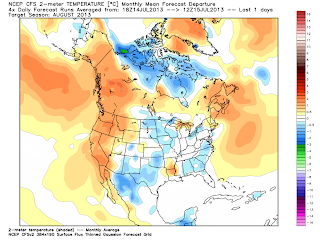
BTW..latest temperature forecast departure from normal for Aug..
If you remember a few weeks back I mentioned Aug would not be as brutal with the heat as July. Looks like that might end up being the case.
image source: weatherbell.com/models


.png)
.png)


