*WINTER OUTLOOK 2017 WILL BE RELEASED ON WEDNESDAY OCTOBER 19TH*
- Hurricane Matthew is currently a Cat 4 hurricane with winds of 130 mph
- It is located in the tropics just south of Cuba moving north
- Models continue to take this storm north over the next few days then start to diverge on where it ends up by this weekend
- Some take it out to sea other make it more of a threat to the east coast
- At this time I am favoring the out of sea track with limited impacts.
- If there are any impacts they will be this weekend
Lets start off by looking at the current storm..

You can see a clearly defined eye and the speculated track by the national hurricane center to the right. This goes along with current hurricane models..

Looking at the major operational models we have quite the spread of what can occur. The image below shows what these models are showing at the surface for this weekend..

Top left GFS, top right is Canadian, and bottom is European model. Notice how the GFS is the most aggressive with this storm. It has it plowing up the east coast with very heavy rain and wind Saturday and Sunday. The Canadian model keeps most impacts off shore and the European is way out to sea.
So whats my take? Well first lets take a quick look at why the GFS is so aggressive. As usual it comes down to the atmospheric set up at 18,000ft...
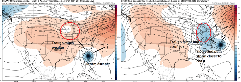
Left is the European upper air pattern and the right is the GFS. I want you to focus on the white and blue colors in the vicinity of the mid west. This represents a trough approaching the area. Notice on the European (left) this trough is much weaker and slower than the GFS (right). The faster stronger trough in the GFS projection interacts with the storm and pulls it closer to the coast. That is why at the surface you see such a drastically different outcome.
Do I buy it? No not at this time. Despite the fact the GFS has been very consistent with this idea for days now, it simply does not have much model or ensemble support (except for its own). Most other guidance supports the European idea of a flatter slower trough and allows this storm to stay far enough offshore to not be a major threat. The Canadian model right now I think represents the best compromise.
Like always this is days away which means there will be surprises and changes. Thus, we can not rule out the GFS scenario. It just is not my forecast at this time.
More updates to come this week!
Irene hit 5 years ago and Sandy hit 4 years ago. Having another major storm come now, although possible, would be somewhat unusual, and may be something to worry about. I hope this thing stays as far away as possible.
ReplyDeleteWilly, you already know that the 12Z runs all moved west and are all now progressive, no more stall north of the Bahamas. GFS hits the Carolinas and then hugs the coast, Canadian pretty similar, Euro nicks Hattaras and then tracks N/E (Euro looks like the GFS of yesterday). The first two models seem to indicate that eastern NJ will get a lot of rain on Sunday, moderate winds. Admittedly, still lots of time for more shifts. Let us know what you think. Jim G
ReplyDeleteYup, big shift today. But like you said we still have a lot of time to go. Do not want to jump on anything yet. Will see by tomorrow morning how much this trend stays in tact. This thing prob will be shifting back and forth through Thursday on models!
Delete