*WINTER OUTLOOK 2017 WILL BE RELEASED ON WEDNESDAY OCTOBER 19TH*
Good morning. Lets dive right into it. Over the last 24 hours there have been some significant trends to bring this storm more west up the coast this weekend. Although this scenario is still not by any means set in stone I need to now assign it a higher probability than I did yesterday. The main impacts of an east coast hit would mainly be very heavy rain and gusty winds as this would become a post tropical cyclone once it merges with an approaching trough.
Here is a summary:
- Hurricane Matthew is currently a very powerful Cat 4 hurricane making landfall in Haiti.
- Winds are gusting over 150 mph and there unfortunatly will be horrible impacts for that country
- Models over last 24 hours have indicated this storm could sweep up the east coast as opposed to curving out to sea
- At this time I assign this a 50% probability
- Impacts would be felt on Saturday and Sunday with heavy rain and gusty winds
- Much can change and I still give this equal chances of just missing our area out to sea
So lets start by looking at this monster on satellite..
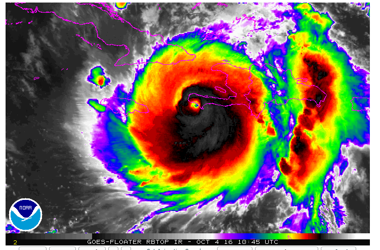
Extremely destructive storm and you can see above how it is making landfall in Haiti.
From here models are now tighter in their projection of this storm moving closer to the east coast..

This spread is much narrower than yesterday which had many more projections more out to sea.
At the surface here is the updated GFS (left), Canadian (right), and European (bottom) models for this weekend..

Take this with a grain of salt for now. We still have over 100 hours to go. A lot can change including this trending back out to sea. Regardless, a big shift west from 24 hours ago.
You can see how if we look up to 18k feet in the atmosphere the European made a big shift (click to make bigger)..

The new run of the European model in the right image shows a much stronger trough approaching in the mid west compared to yesterday. Also, notice more red (high pressure) in the Atlantic which helps slow this storm down.
So as you can see we have to watch this situation extremely closely. I expect there to be more changes in the models especially in next 48 hours. For those of you who have weekend plans, I would not cancel anything yet but would be on high alert. I think by Thursday we will have a good grip on this situation. Lets see how this trends over next 24 hours.
More to come.
No comments:
Post a Comment