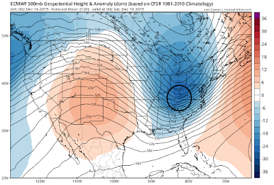
- We need to keep our eye on Friday the 19th for a possible storm system to develop due to the overall pattern. This would be only a wintry threat for interior areas.
- Regardless if this storm materializes our first true winter air arrives this weekend. Temps will only get into the mid 30's and low 40's for many spots Friday through Monday!
- The pattern is starting to show signs of change (stratosphere) but it still would likely be January before we see the full evolution.
Starting off with my storm speculation for Friday. Over the weekend the models did make more of a supportive evolution towards this idea, including the latest run of the European. Still not ready to pull the trigger on this but I like the trends for at least a shot at some accumulating snow for Ski Country.
Remember how I showed an image like this below of upper air energy and why the European was not showing a storm last week...
Basically the upper level energy was too spread out as I indicated again above. Fast forward to the run from last night and you now have this valid for the same time..
I cannot show the higher resolution version of the European but the point is consistent. The more consolidation of upper air energy you have the bigger shot at a storm that is closer to the coast. Moving down to the surface we now have this on the European..
Nice area of low pressure that develops which would give interior New England especially Ski areas the shot at a few inches of snow. I can probably show this point better with an image of the GFS upper level energy. I put this next image up on twitter yesterday. It shows the difference between Saturday and Sunday's run of the gfs model. Notice the new run on the right has more interaction of energy..
Thats really how this works guys. Its all about how energy interacts at 18k feet and its effect on the surface. That is why pattern recognition is so important. If you can identify a pattern that can support a storm then you start to look for trends like you see above. This is the latest surface on the GFS..
More of a wet scenario here for all areas, but regardless a storm is in play.
Bottom line: The jury is still out but the shot at a coastal storm for Friday is still very much on the table. This would mainly be a rain threat for most areas except interior New England. We will be able to nail this down within next 48 hrs.
Moving on to our warm weather pattern. I never thought on December 12th Id be playing tennis and golf but that is what the past weekend had in store. In fact, even these popped up in my yard..
Mother nature is obviously confused about this pattern as well. So moving on to the bigger picture. You can see our shot of arctic air this weekend..
This only lasts through Monday then we return to our warmer than normal pattern. Based on my winter forecast, I am expecting a pattern change by January. This is only going to happen if we are able to break down the cause for this abnormally warm weather- a very storm polar vortex. I have mentioned that the only way to change that is by seeing warm air invade the stratosphere. Trends are still alive that show this occurring. The next image shows the difference between the current conditions at 10mb (way up in the stratosphere) and projected conditions.
Notice the heating that is occurring near Asia on the right image and how the polar vortex is getting stressed out because of this. THIS IS KEY. If this verifies, and the trends now are still insisting it will, I am confident we will get our pattern change. A weak polar vortex allows shots of arctic air to leave the pole and bleed into North America.
Until then, we will still be in a weather pattern that is overall warmer than normal through at least Xmas with the occasional shot of arctic air. Winter is not over, be patient.
Thanks for reading, more to come.


No comments:
Post a Comment