WINTER OUTLOOK 2023 IS NOW LIVE
Friday Morning Weather Update: My Storm is On Some Models, But Long Way Off Still
Good morning everyone. This post will focus on my target period of the 16th though the 24th. In particular we will look at the weekend of the 19th. I have talked about the overall set up in the weather pattern over my last several posts. In summary, I am not expecting a full pattern change until we get to January (based on observations and my winter forecast) but I mentioned how there are signs we can see a period of action before then. Mainly this could be in the Midwest into Interior New England. A big reason why was the projected set up of the jet stream for that period...

The map above shows the overall idea for the target period. We have high pressure forming over Gulf of Alaska. That presses cold air into the country. We also have some blocking develop just south of Greenland. This also helps trap the jet underneath, especially the cold air that the Alaskan high pressure system is seeding. The idea is that there is a chance we can get this energy consolidated enough that a storm can form on the cold and warm air boundary by the weekend of the 19th.
It is still mostly speculation due to the fact we are 7+ days away but it is still worth mentioning in my opinion. The GFS has been the model consistent model showing something trying to develop at the surface for that weekend..
This would be the overall idea of what could happen- a storm that develops along that boundary and effects interior areas with snow. Pretty much a ski country special. But we need to start seeing a lot more support from other models and their ensembles.
The European does not have a storm due to the energy I talked about staying too spread out...
This map above shows the Europeans upper air projection. notice how spread out the blue is and we can try to identify a few different centers of energy.
Compared to the GFS below which is more compact.
Thats really what it comes down to guys. The models as with any potential storm threat will need a few more days to sort it out. Remember however if this does end up developing I am expecting it to be more focused on the interior not the big cities or say even 80 miles to the west.
I will keep an eye on this as we head through this weekend.
On another quick note the stratosphere is still showing signs it comes under stress in the longer range..
This is the main factor I am looking at to support my pattern change idea for Jan as it would weaken the polar vortex and give us the chance for more sustained shots at cold air.
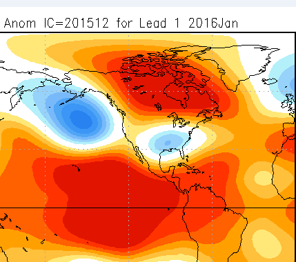
This is my original January forecast from my winter outlook..
Latest NMME blended model guidance for January (came out yesterday)..
Lets see how this unfolds!
Thanks for reading.


No comments:
Post a Comment