Friday, January 31, 2014
Friday Morning: Detailed Video Looking at Action Packed 10 Days Ahead
Although a little longer than normal, this video discusses the active weather pattern we will see for the next 10 days. We have three shots of snow due to an active southern jet stream throwing up moisture into our area. The first shot is a wave of low pressure Monday that can drop a few inches, the 2nd is a large storm that will start as snow then change to ice and rain, then finally next weekend we can see another large all snow event. This should set up to be a very impressive winter period, if it does not I will be disappointed and pretty surprised. Good details in video below.
Thursday, January 30, 2014
Big Storm Next Week: But Will It Be All Snow?
Good morning. A large storm will effect the eastern 1/3 of the country next week. As I mentioned yesterday this storm will carry with it a large amount of moisture due to it originating out of the sub tropical jet stream. It will develop in the Gulf of Mexico and move northeast right into our region. Ahead of this storm there will be cold air in place. The million dollar question is how strong is the cold air in place, meaning will it hold its ground and also when does this storm phase with the polar jet stream. If the storm phases too early then it will wrap up warm air from the south into our area resulting in a snow changing to rain scenario. If the two disturbances phase later then we have a very significant snowfall possible. It is almost impossible at this time to say what scenario will occur, we can only speculate. Lets take a look at the features.
Below you will see the two disturbances I am talking about..

Ahead of these two approaching disturbances here is the cold air due to an arctic high over our region..

Now if those two disturbances combine too early you get a a southern flow on the eastern edge of the storm this pulls in the warm air as you see on the next image...

This would result in a snow changing to rain scenario as the cold air gets overtaken by the southwesterly flow of warm air due to the placement of the low pressure center to the west of our area. You always want to be on the cold side of a storm which is the western edge of the low pressure.
So here is the forecasting issue, no one knows when those two disturbances will combine, thus it is very hard to predict if we will see all snow or snow changing to rain for our area. Some model runs have kept North Jersey in all snow, while others have not. This will continue to flip flop over the next few days so no one can get caught up in one model run. The main point here is that someone is going to get a lot of snow with this system, most likely over a foot. In addition, there is another similar storm that could develop on its heals and give us a 2nd shot at snow. The pattern is extremely active right now, we just need to have a little luck on our side if you want snow. If I had to make a call right now here is what I think, and again this is purely speculative but this would be my first guess based on how I think things will trend...

More updates later tonight.
Below you will see the two disturbances I am talking about..
Ahead of these two approaching disturbances here is the cold air due to an arctic high over our region..
Now if those two disturbances combine too early you get a a southern flow on the eastern edge of the storm this pulls in the warm air as you see on the next image...
This would result in a snow changing to rain scenario as the cold air gets overtaken by the southwesterly flow of warm air due to the placement of the low pressure center to the west of our area. You always want to be on the cold side of a storm which is the western edge of the low pressure.
So here is the forecasting issue, no one knows when those two disturbances will combine, thus it is very hard to predict if we will see all snow or snow changing to rain for our area. Some model runs have kept North Jersey in all snow, while others have not. This will continue to flip flop over the next few days so no one can get caught up in one model run. The main point here is that someone is going to get a lot of snow with this system, most likely over a foot. In addition, there is another similar storm that could develop on its heals and give us a 2nd shot at snow. The pattern is extremely active right now, we just need to have a little luck on our side if you want snow. If I had to make a call right now here is what I think, and again this is purely speculative but this would be my first guess based on how I think things will trend...
More updates later tonight.
Wednesday, January 29, 2014
Wednesday Morning Forecast Discussion: 150 Miles Off
Good morning. Well the south got their storm with many areas receiving several inches of snow and ice. I ended up being off by about 150 miles from what my original ideas where 10 days ago. I guess even tho the storm did not materialize as I thought I wasn't off by too much given the grand scheme of things of a storm actually occurring.
Lets turn to what I believe will be our next POTENTIAL threat. I am starting to focus on around a week from today for a potential significant storm to effect someone in the Eastern 1/3 of the nation with heavy precip/snow. What we will have is a very active southern jet stream that is going to open up its faucet and spray moisture up into the country. Energy coming off of the Pacific jet is going to try to combine with this moisture somewhere near the Gulf of Mexico and try to bring a moisture rich storm up through the eastern states. The question is how does this storm phase and will the polar jet get involved to give us a triple phased system along the east. Last nights GFS shows the three jets trying to line up...


Lets turn to what I believe will be our next POTENTIAL threat. I am starting to focus on around a week from today for a potential significant storm to effect someone in the Eastern 1/3 of the nation with heavy precip/snow. What we will have is a very active southern jet stream that is going to open up its faucet and spray moisture up into the country. Energy coming off of the Pacific jet is going to try to combine with this moisture somewhere near the Gulf of Mexico and try to bring a moisture rich storm up through the eastern states. The question is how does this storm phase and will the polar jet get involved to give us a triple phased system along the east. Last nights GFS shows the three jets trying to line up...
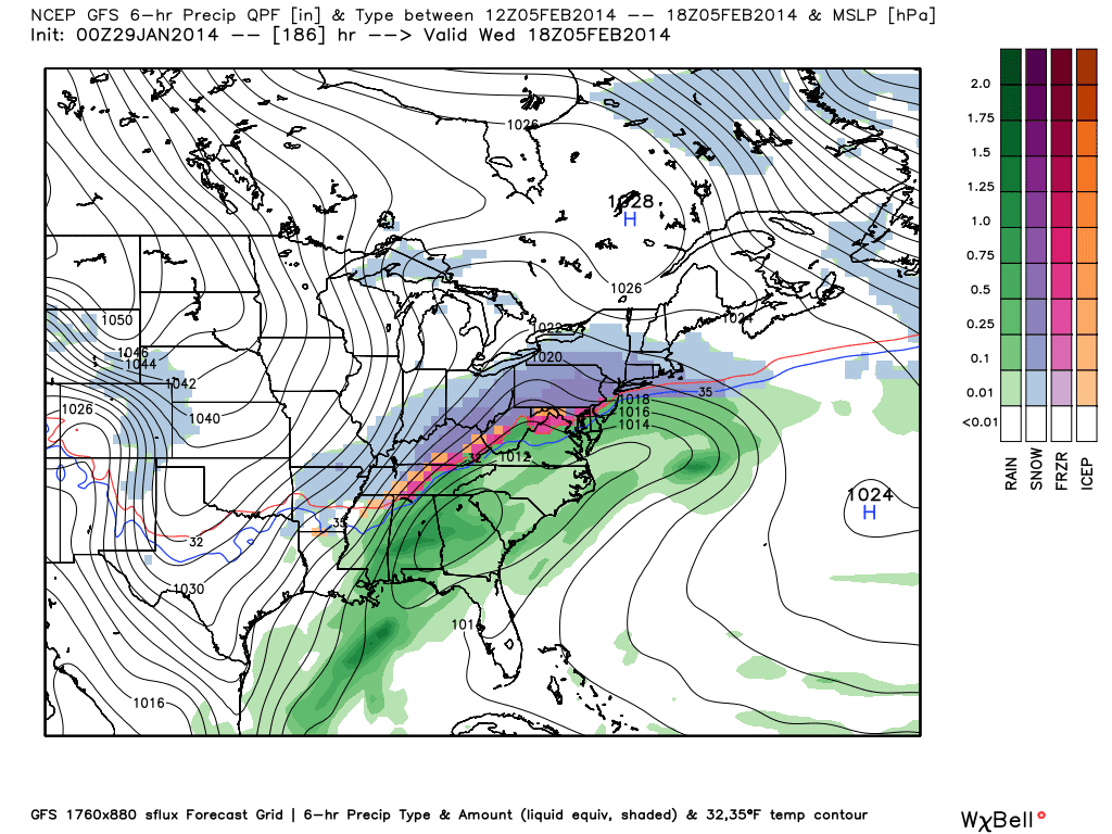
This would produce a storm similar to this...
Total precipitation amounts of this...
I think you can see the moisture I am talking about with this system. It bears watching. The models will keep shifting with this and it is possible we get rain for our area and snow more to the west. It is too early to say at this time. I will keep updating as this evolves.
Tuesday, January 28, 2014
Latest Snowfall Projections for Southern Storm: South Jersey Gets Skimmed

The storm has trended north, but not far north enough to really give the tri-state area any meaningful snowfall. The only part of our area in the snow is extreme SE NJ. Areas to the north and west will get a light accumulation. Although this is a drastic shift from days ago, it did not shift as much as I originally expected it to. This will be a major storm for the deep south and Carolinas.
The Superbowl will be a milder day with rain possible earlier in the day. Earlier next week we can see a shot at more snow. I will have to take a closer look at things in the coming days. The overall pattern is changing, we should see a battle set up between warm and cold air along the east coast. Whether we get snow or not in this pattern will depend on the strength of the NAO.
Monday, January 27, 2014
Throwing In The Towel
Now that its Monday morning I can safely say it would be too drastic a shift in this short period of time for the models to correct north to effect our area with precipitation. I hung on to this one for a while maybe too long, but I saw a lot of potential a week out and the way this winter has gone so many things have changed last second. The upper air dynamics are not favorable for this storm to move up the coast and even if some of the models are making errors it is unlikely that the errors will be large enough to change the path of the storm too drastically. So what is now likely to happen is the south gets a rare snowstorm. Here is the latest snow printout from the GFS...


A stripe of several inches of snow will occur for northeastern GA, SC and NC. This is is a major storm for down there since they do not have the same resources we do to deal with the snow. Even notice it could snow in parts of Louisiana eastward towards northern FL. A rare event indeed, but no snow for us. So far it has been a decent winter for our area in terms of snow, but no blockbuster 12-18 inch type storms. Will Feb bring on of those? Impossible to say since a storm like that is not very common. The pattern will stay stormy for Feb and a big fight should break out between warm and cold air along the East coast. That can result in several wet and frozen precip events.
I will take a look at the model runs today for any last min changes, but consider this me closing the books on the Wednesday threat.
Sunday, January 26, 2014
Sunday Night Video: Not So Fast My Friend
Some people think they know it all in the weather community, just like some experts think they know it all in the financial industry. I certainly do not know it all, but I like to follow trends. Both short term and season long trends. The seasonal trend has been for the models to not handle northern short waves properly this has resulted in many last second changes to many weather forecasts for snow. Now taking a look at next weeks storm, the consensus all weekend has been this is a southern slider. That means the storm is going to give the southern states snow and leave us dry. I think 99% of the weather community has bought into that idea. However all these forecasts are based on assumptions. We all know assumptions change and based on how those assumptions change is going to dictate what happens with the projected weather. So lets focus on the inevitable errors a model will make then just make our forecasts based on current assumptions. Now I might be nuts here to still be holding onto the idea of a storm coming up the coast this week (the current upper air assumptions do not support me), but what the heck might as well have a little fun and see how wrong or right I end up being. Details on latest trends in video below.
Saturday, January 25, 2014
Friday, January 24, 2014
Friday Morning Weather Discussion
Good morning. I was going to cut a video, but instead this post will be a follow up of my last video where I discussed the active 10 days ahead. I speculated that we would see light snow on Saturday, again on Monday, then a possible bigger storm to follow later in the week. Lets see what model trends look like.
Models keeping the light snow threat consistent for Saturday- Coating to an inch or two some spots

 ''
''


Models keeping the light snow threat consistent for Saturday- Coating to an inch or two some spots
Monday looks to be more of a snow shower event as main low stays to our north..
''
Now things still have the potential to get interesting mid to late week as we have extremely cold arctic air over the country with a lot of energy in play. I am keeping my eye on a disturbance diving down from Canada and another disturbance developing in the southern stream. Will the northern disturbance dive deep enough to combine with this southern stream disturbance? The European hints it could..
You can see the two disturbances circled above. If the northern one stays shallow then we do not get a big storm. Also if the southern one drags its heels it becomes harder to form a big storm as well. What we need is a sharp dive of the northern energy, more than the model is predicting. At the surface the euro trys to combine these but does so late and off shore..
Two days ago no storm was even on the map when I cut the evening video, so the trend is there on all models may I add. If the modeling continues the same error it has made all winter of not diving the northern disturbance deep enough then we have a big issue on our hands. This is a very rare cold arctic air mass that will be over the country during this period. If we see an earlier and deeper phase of these two disturbances then it could snow as far south as GA and come right up the coast. Will this happen???? All I can say now is it is not the general consensus but has me concerned. I will be looking for a correction here.
Hey weatherwilly how about the Superbowl?
Some interesting buzz is going to begin about snow on the Superbowl. Models are hinting at a wave of low pressure trying to develop in the morning and spreading some snow into the area. It bears watching, but I do not anticipate a big storm at this time during the game.
Wednesday, January 22, 2014
Wednesday Night Pattern Update: Buckle Up
In the video below I explain my thoughts on the weather pattern over the next 10 days. This period will be categorized by extremely cold temps, multiple episodes of light snow early in the period, followed by the potential for a big weather event middle to end of next week. All details in video below.
Wednesday Discussion: Storm Totals and A Look at Next Week
Good morning. Yesterday turned out to be a nice snowfall in most parts of the state. My finalized snow map was almost spot on but I am not going to give myself too much credit because I changed it yesterday morning. Although we saw some impressive amounts in spots up to 13 and 15 inches localized, my original map prob would have been better in terms of averages. In any event here was the final result.
My Map:


My Map:
Storm History (click to make bigger):
Here are the charted snowfall reports NJ Snowfall Reports. So overall I first mentioned potential on this storm for January 5th. However I did wavier a little over the last week only saying that this could shift to be a moderate snowfall and I had to upgrade towards the end since it was heavier than I expected. I'll give myself a B- on this one.
In any event that big pattern change is now here. We have had our first large spread accumulating snow event so whats next?
For one this cold air sticks around for a while, so the snow stays on the ground. Secondly and more importantly I am keeping my eye on middle of next week for a potential coastal storm. A big part of the reason is the southern jet stream is going to become active again. With the cold air already in place, all need need is a northern jet stream impulse to phase with the moisture for the southern stream and we get a classic storm.
Here are the ingredients below:
Moisture developing in the Gulf along with energy diving down from Canada could combine.
More on this as the days go on. Expect some episodes of light snow as the week rolls on.
Tuesday, January 21, 2014
Raw Footage of Today's Storm
I will have a closer look at our next storm threat late tonight along with a summary of today's event. As I have been saying this pattern is active.
Tuesday Morning: Time to Up My Snow Totals
The stronger trend has continued, need to up my snow amounts. Updated play by play video below. Snow will break out later this morning and increase in intensity throughout the afternoon and reach peak intensity tonight. Traveling this afternoon and tonight is not advised. Frequent updates later this afternoon and evening.
Follow me on Twitter for more updates @weatherwilly

Monday, January 20, 2014
Monday Night Update
Models have trended stronger with storm all day. This will likely result in snow amounts that are slightly above my initial projections. Might make a few small tweaks tomorrow morning. Snow starts by late morning and gets heaviest by tomorrow night. Statewide snow amounts of 6-12 inches looking likely. Final update in the am
Updated Snowfall Map and Play by Play for Tomorrow's Storm
Below is my updated snowfall map for tomorrow's storm. I cut a video that is processing now that will have the play by play. That will be up shortly. In any event glad this storm worked out as part of my January 5th Discussion
Amounts below are what I expected each shaded region to receive on average if we took the mean of what the storm reports will be.

Play by play video..
Amounts below are what I expected each shaded region to receive on average if we took the mean of what the storm reports will be.
Play by play video..
After this storm we will have to keep our eyes on late next weekend/early next week for a potential bigger storm. More on that as the days go by.
Sunday, January 19, 2014
Sunday Night Video Discussion: Snow Threat for Tuesday
Abstract:
A moderate winter storm looks like it will impact the area Tuesday morning into Wednesday. This storm will develop along an arctic front producing high ratio snows for much of the forecast area, similar to what occurred earlier this month. Earlier in the week the modeling kept this storm out to sea due to the complexities between the interaction of the arctic front and the timing of the upper air disturbance from Canada. However, all year we have seen the modeling repeat the same error of not driving these disturbances deep enough into the CONUS which results in an offshore solution. It looks like that error has occurred again we are now seeing the westward correction in model guidance. Right now I am seeing a general 3-6" snowfall for our region. More details in video above along with Superbowl thoughts.
Models Trending West for Wednesday
I'll have more right before the football games start today, but the GFS has been trending west with Wednesday off shore storm. I mentioned in the last video I thought this could happen. I still don't see a big snow threat, but more in line with my ideas of a light to moderate snowfall possible. More later.
Saturday, January 18, 2014
Dry Air Needs To Leave

We will see big storm once this dry air in the Gulf of Mexico breaks. Models are indicating this should happen by end of next week. We need an active southern stream for the bigger storms. All the southern stream moisture is building off the southern coast of CA. Once this dry air dam breaks, lets hope the cold air is still holding and we have potential.
Friday, January 17, 2014
Thursday, January 16, 2014
Thursday Night Update: Action on the Horizon
Here was my original outlook from Sunday January 5th.

Polar Vortex crashes into our area Tuesday causing the lowest temps in 20 years over the country.
2. We have a shot at light snow Friday
3. This is followed by a mild weather pattern for about 7 days.
4. After January 15th all indications (explained in the video) are for winter to make a sharp return
5. I am looking at the threat for a storm between the 16-19th and then again on the 22-24th
6. This progressive pattern should continue into Feb.
It is now January 16th and here is what has happened:
1. We got light snow that Friday (half inch in some spots)
2. The weather pattern got mild up until today.
3. It is now January 16th and Winter WILL make a sharp return
4. There will be no big storm between the 16-19th, the storm will develop but off shore just giving us snow showers this weekend.
5. There is potential for a big storm on the 22nd, but the details need to be worked out
6. Feb should be very special this year in terms of cold and storminess
So now that I graded myself lets get to Wednesday the 22nd. Here is the upper air set up
Upper air pattern supports storm to develop based on:
1. high pressure over Greenland
2. Ridge out over west coast
3. Upper level pressure area north of Nova Scotia (a critical part of big storms)
What will determine if this is another storm out to sea or a significant winter storm will be the timing of the northern and southern branch of the jet streams phasing (as usual). I have been out in NYC all week so my access is limited but I will take a very close dive at this tomorrow morning in a video. Also a Superbowl prediction is on the horizon as well.
We have a hell of a period of weather over the next 30 days. Stay tuned, this could be special. More tomorrow.
Wednesday, January 15, 2014
A Quick Remark
Although we will miss out this weekend, this weather pattern is undergoing a massive change to cold (very significant) and stormy. By next week this maturity in the pattern will slow down the pattern and result in an increased chance for storms to wind up. My prediction from Sunday the 5th of January mentioned a storm around the 19th (not going to occur, out to sea) but a major pattern change after the 15th (Will occur) and another storm between the 22 and 24th (on the table right now). So far I can confidently say I got one of the three correct w the cold and the jury is still out for a storm around the 22-24
MORE LATER
MORE LATER
Wednesday Morning Update
Good morning. After going long on Monday for a storm this weekend, it appears at this time my ideas will not come to fruition. The pattern did not slow down as I was anticipating and will be too progressive (fast) thus the storm will not be able to mature along the east coast. You win some you loose some, but I like to take a chance once in a while in order to make this page more enjoyable. I saw this pattern change coming two weeks ago (that part I got right) and knew the pattern could produce a storm as It will, just 100 miles out to sea (I know that doesn't count). As long as I am not wrong more than I am right I can deal with that. I want to try to give you guys a longer term perspective instead of being overly conservative. In any event here is the problem with the weekend system..
 The trough does not have a negative tilt, so the storm does not wind up along the coast and also I did not anticipate another disturbance behind this system as seen by the circled yellow area. This small disturbance will keep the flow progressive and kick the storm more to the east. The end result is development off shore. We still are a few days away so there always is a shot things can change, but I have no data to support my original idea at this time so I need to state the facts.
In any event my ideas behind the weather pattern are very firm and we will lock into a cold stormy pattern, we just need to be patient and wait for this pattern to mature and we will get our fair share of snow. The biggest headline in the next few weeks will be the cold along the east coast. Don't be surprised if you hear the term "Polar Vortex" again as it is possible it will take another trip to our area. The only difference this time is it would come in the dead of winter which means conditions could actually be colder than last time, but now we are getting ahead of ourselves. The important thing to know is the potential is there for very cold weather and the potential is increasing everyday. Snow will come.
Keep checking in as I will continue to keep an eye on things.
Tuesday, January 14, 2014
Monday, January 13, 2014
Monday Night Video: I'm Going Long on the 18-19th
Making a call for this weekend. I've talked about it for a week and although so many details are uncertain and inevitably will change, I like the trend I see for a storm to develop. All information is in the video below and many more updates to come. Let's see if I win this one or get burned; should be fun to watch evolve. In any case we are going to be in a snow lovers winter pattern though end of January. Many shots at snow. Keep checking in for frequent updates on this evolving weather pattern hopefully it isn't a dud!
**Correction I said 5,000ft for the first map it is a 500mb map which is around 18,000ft in atmosphere
**Correction I said 5,000ft for the first map it is a 500mb map which is around 18,000ft in atmosphere
UPDATE
The latest European model has picked up on my ghost storm for the 19th. I finally am starting to get model support. Let's see if trends continue. More tonight.
Sunday, January 12, 2014
Sunday Night: The Heart of Winter Coming
Didn't want to go into great detail in the video below because a lot of details still need to work themselves out, but we have an active period of weather coming. After Wednesday things will get very interesting as the upper air pattern I discuss in the video becomes ripe for storm development. I first mentioned this pattern change last Sunday and the trend has been strong since. And yes I still have my eye on the 19th for potential storm development. Winter should hold strong through Feb this year based on all the trends I am looking at. In fact, this could be one of the better patterns I have seen in recent years. Lets see if the trend continues. Much more info and updates in the days to come.
Friday, January 10, 2014
Trend for the 19th Looks Better Today

I talked about in video last night about how we would see a moderate storm next week (around the 15th, looks like an inland snow event but will keep and eye on it) then a chance for a more progressive set up based on the upper air pattern for the 19th time frame. The image above shows the latest European Model Ensemble for that time and it has trended stronger and try's to phase the northern and southern jet streams. No big storm on surface map yet, but the trend is good. I circled above what I am referring to. In the video last night this looked weaker for the same time frame.
Jury is still out on next week. Some models have rain followed by a snow event on its heals. I will see how that trends this weekend. Not ready to pull the trigger on snow yet for middle of next week, but it is in the cards for my storm #1 prediction. So moderate event in the cards next week, but my eyes are on the 19th and towards the end of January for a bigger system as I have consistently been discussing since Sunday. Lets see how things turn out.
Thursday, January 9, 2014
Thursday Morning: Looking Past the 15th
No video today, having technical issues. Will try again tonight. Will definitely have a full in depth post/video tonight around 7. Don't have the time now to go into detail, but my ideas on Sunday night look good . I think of chances of a storm after the 15th are increasing the way the pattern is setting up. The cold and stormy pattern should continue through February. I have a feeling the heart of our winter is coming up.
More info with exact details tonight.
More info with exact details tonight.
Wednesday, January 8, 2014
Not Much to Add Today
Bitter cold will end today and temps will moderate to more manageable levels. By the weekend the warm up comes and temps go into the high 40's low 50's. I do not expect this thaw to last long. After the middle of next week things will start to get interesting again as I have been mentioning. I am still looking at the period of January 16-24 for the potential for one or two storms. I outlined the reasons why in my Sunday night video and my thoughts have not changed. Nothing is ever guaranteed, its very hard to get a big storm but I like the overall trend in the pattern. Things should get active again.I will take a closer look at this as the target period closes in. Stay tuned.
Tuesday, January 7, 2014
COLD!
Doesn't get much colder than this around here. Take a look at the current temps from all the weather stations across our region along with the wind chills. Temps are in black, the wind chills are in blue. Temps negative to single with wind chills in negative double digits. This is a record breaking cold spell, but not for all areas. It has gotten this cold before. Its not common, but it happens.


The term polar vortex was so misused yesterday by the media. It always exists and usually is located over the pole. However, it is known to get displaced form the pole when the stratosphere warms causing it to split. There are numerous times where it has dropped down into America or Europe during a winter because of this. This time, it happens to have our area at ground zero. You can see the vortex below. This is at 5000 ft in the atmosphere.
Following my video, I still like the trends for a stormy return to winter after January 15th. More on that as the days go on. You can see the video on the post below.
Sunday, January 5, 2014
January Weather Pattern Update: A lot to Talk About
Below are my latest thoughts and analysis of the long range weather pattern through the end of January. In short, get ready for a strong return to winter after a few days of mild conditions later this week. I think our next shot at a big storm will from the 16-19th and then again from the 22-24th. I explain why in the video.
Detailed video below I recommend you watch..

Detailed video below I recommend you watch..
Here is the quick summary for those who are not interested in the finer details..
1. Polar Vortex crashes into our area Tuesday causing the lowest temps in 20 years over the country.
2. We have a shot at light snow Friday
3. This is followed by a mild weather pattern for about 7 days.
4. After January 15th all indications (explained in the video) are for winter to make a sharp return
5. I am looking at the threat for a storm between the 16-19th and then again on the 22-24th
6. This progressive pattern should continue into Feb.
One major factor in this forecast are temperatures rising in the stratosphere (highest levels in the atmosphere). When the stratosphere warms, it causes the polar vortex to split and creates cold conditions for the USA 1-3 weeks later. Below you can see the stratosphere is starting to warm as indicated by red and yellow colors.
That stretched area of low pressure is the polar vortex under attack in the image above. Normally the vortex should be circular over the pole. The end result 1-3 weeks later very cold conditions over the lower latitudes (US and Europe) due to the vortex being displaced south like we will see on Tuesday.
More in the coming days...
Saturday, January 4, 2014
Saturday Quick Summary
Good afternoon. Thanks to everyone who checked in for the storm, I got thousands of hits and new followers. Greatly appreciated.
Snow totals where in my 5-10 inch range for most of the forecast area. I was a little underdone for some of the coastal areas that received some locally high amounts close to a foot. Up in New England, the heaviest snow form this storm occurred. Some areas near Boston received close to 2 feet. So overall the forecast worked out well.
I am going to cut a video tomorrow night to give a detailed pattern update but in a nut shell here is what to expect. Rain tomorrow night and Monday ending in show showers. High temps in the mid 40's. Temps will then CRASH Tuesday into the single digits for many areas and everything will flash freeze. This is due to the polar vortex moving over our area shown below...

This green area is normally over the North Pole, just to give you an idea of how cold it is going to get. Here are the temps Tuesday morning. You can click image to make it bigger. The grey is the below zero. Hasn't been this cold since 1994.

We might see some light snow end of the week then we will experience the "half time" to winter as temps will moderate into the 40's and possibly the 50's by next weekend. This is normal for this time of year and is called a January thaw. However, I expect winter will return towards the end of the month and will a hard punch. I will go into reasons behind why, and when the potential for the next storm will be in my video tomorrow.
Friday, January 3, 2014
Snow Totals Coming In: Summary Post Tonight Along with Pattern Update
Clink the link below for snow totals. Wide spread 5 to 10 inches reported. In line with my forecast. A few spotty higher amounts than forecasted to the south but solid overall.
STORM SNOWFALL TOTALS
STORM SNOWFALL TOTALS
Final Video Update: Raw Footage
Storm is now really cranking up. Most of the accumulations will now occur until about 4 am. Below is some raw footage of the current conditions that will persist for the next few hours (now you know i'm crazy). Tomorrow will be a slow start for sure.
Current Radar: This was/is the banding that will cause the snow to pile up..
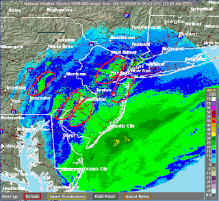
Winter is off to a nice start. More on the overall pattern for the rest of the month along with the finalized snowfall totals tomorrow. Thanks for following today.
Current Radar: This was/is the banding that will cause the snow to pile up..
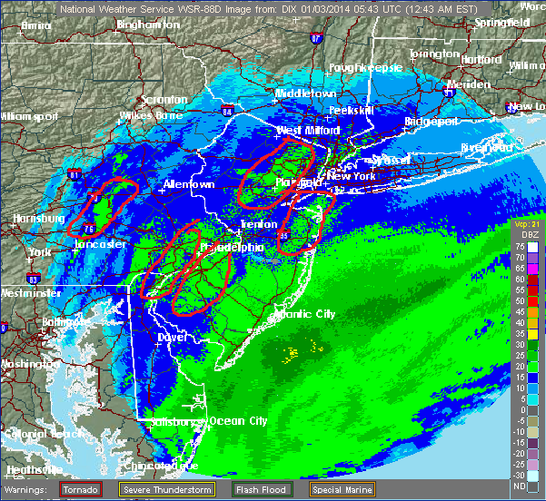
Winter is off to a nice start. More on the overall pattern for the rest of the month along with the finalized snowfall totals tomorrow. Thanks for following today.
Thursday, January 2, 2014
6pm Evening Update:Storm Intensity Really Ramping Up
Now is good time to get off roads this storm is really winding up and will only get worse. Blizzard conditions at times tonight. I will have frequent updates over twitter @weatherwilly, on this web post and cut another video when the storm ramps up later tonight.
Play by Play for Today/Tonight's Snow Storm
Everything you need to know in video below (snowfall totals,snowfall rates,winds,timing of storm). On another note, storm next week looks wet guys. Things can still change but the upper air support is not in place as of now for a Northeast snowstorm. Looks like an inland runner. Brutal cold however in the wake of this current storm and following the rain next week.
Here has been my going snowfall map published Tuesday morning. Some slight tweaks mentioned on this map in the video.

The National Weather Service recently updated to come in line with the same idea..
Update later this afternoon.
Here has been my going snowfall map published Tuesday morning. Some slight tweaks mentioned on this map in the video.

The National Weather Service recently updated to come in line with the same idea..
...WINTER STORM WARNING NOW IN EFFECT FROM 1 PM THIS AFTERNOON TO
1 PM EST FRIDAY...

* HAZARD TYPES...SNOW ALONG WITH AREAS OF BLOWING AND DRIFTING
  SNOW.

* SNOW ACCUMULATIONS...6 TO 10 INCHES.

* TIMING...SOME SNOW IS POSSIBLE THIS MORNING THROUGH EARLY
  AFTERNOON... HOWEVER THE SNOW WILL THEN INCREASE BY LATER THIS
  AFTERNOON WITH THE BULK OF THE SNOW EXPECTED TONIGHT AND FRIDAY
  MORNING.

* IMPACTS...TRAVEL WILL BECOME HAZARDOUS LATE TODAY AS SNOW
  INCREASES. THIS WILL BE AN INCREASINGLY FLUFFY SNOW AND AS WINDS
  INCREASE TONIGHT... BLOWING AND DRIFTING SNOW WILL MAKE TRAVEL
  EVEN MORE HAZARDOUS. ROAD PLOWING OPERATIONS WILL BE GREATLY
  AFFECTED... ESPECIALLY DUE TO BLOWING AND DRIFTING SNOW AND ALSO
  SNOWFALL RATES NEAR AN INCH PER HOUR AT TIMES DURING THE HEIGHT
  OF THE STORM TONIGHT. IT IS POSSIBLE THAT THE COMBINATION OF
  SNOW AND WIND CREATES NEAR BLIZZARD CONDITIONS AT TIMES...
  ESPECIALLY FOR AREAS FARTHER EAST.
Update later this afternoon.
Wednesday, January 1, 2014
11pm Quick Update
After studying everything closer I can honestly say I do not have much to change since my video this morning. I will have a play by play video first thing in the morning which will likely show an increase in my snow amounts in long Island and the Boston area. Otherwise I like the map I put out. This will be a moderate to strong storm with spurts of intense snow and winds especially near the coast which will really peak tomorrow night. Snow showers tomorrow turning to steady snow by later tomorrow afternoon. Heaviest snow will be tomorrow night late.
New Years Day Storm Update
Next Update Later Tonight. Totals might be upgraded a little based on the new models all trending to a more powerful storm. I want to wait and see.
In the meantime here is some eye candy courtesy of the Regional Canadian model...

In the meantime here is some eye candy courtesy of the Regional Canadian model...

Subscribe to:
Comments (Atom)