A clipper system will dive down into the eastern US this weekend (clippers are weak low pressure systems that originate from Canada) . Right now it looks like it wants to bring some light snow to our area Sunday and Sunday night. Nothing to write home about right now, but in some cases these clippers like to reorganize and develop into stronger storms just off the coast. It does not appear that will be the case at this present moment, but things can always change. We are in a pattern over the next two weeks that will yield a few of these clipper like systems so one of them turning into a stronger storm is always on the table.
As for temperatures over the next week expect colder conditions with highs in North Jersey ranging from 28-34, and Mid 30's for central and south. February will be a cold month overall and for what its worth I expect to give us the most winter weather of this season (not much to compete with so far).
Check in for any updates on the clipper for Sunday..but as of now it is nothing of big concern.
Thursday, January 31, 2013
Wednesday, January 30, 2013
Evening Update on Storm Front Coming Through
The heaviest rain and wind will occur when everyone is sleeping tonight and may carry into the daybreak hour. This is all due to a massive cold front that is sweeping across the entire united states...take a look, you can see the front as evident by the sharp contrast in temps between blue green and yellow (blue is below freezing)

When this cold air approaches out area tonight, it will collide with the warm air over our region resulting in an intense band of rain, wind and thunder as seen in this next graphic which shows peak wind gusts which will occur sometime between 1-7am..


Tomorrow night I will update my forecast for the month of February with projections on temps and speculation on how many snow events I think we will see...

When this cold air approaches out area tonight, it will collide with the warm air over our region resulting in an intense band of rain, wind and thunder as seen in this next graphic which shows peak wind gusts which will occur sometime between 1-7am..

Over NJ the light and dark purple represent gusts up to 50 knots, which is slightly greater in MPH. This should cause some minor damage to the area but nothing like sandy as the winds will not last as long or gust as high...in general this is like a summer or spring time cold front
The final result after this passes though are cold temps, and I believe in general the cold is here to stay in Feb..

Big Rainstorm Tonight With High Wind
Real quick because I have a busy day, but a very strong cold front will swing through our region late tonight and early tomorrow morning. Rain will start around 10pm and last to around day break. The main issue will be high wind gusts. Expect gusts of 55 to 60mph which leaves room for caution. Also there will be some thunder and lightning. It may feel like a summer like storm but behind it will be very cold air in the 20s and 30s that will stick aroind for a whole. Winter is not over and February will be a very active month. No big storms on map yet but many chances at small events over next few weeks. I will post in more detail w graphics on tonight's storm and upcoming winter pattern late tonight..check in
Sunday, January 27, 2013
Sunday PM: North Jersey Ice Event for Monday
Tomorrow will be a messy day overall. A area of low pressure is forcasted to move west of our area bringing with it snow (max of 1 in) changing to ice then to freezing rain. As the snow spreads into our area after 9 am, warm air will then move in aloft and cause the snow to change to sleet then freezing rain as the day progresses. Expect the precipitation to last until dusk, and although the roads will be treated there will still be slick spots on ramps and overpasses so be careful commuting home especially if you live anywhere north of I-78. Here is a timeline to help out with travel tomorrow...
9am: Snow spreads into the area light to moderate expect up to an inch in some spots
11am: Snow begins to change to sleet and freezing rain from southwest to northeast, some areas in north jersey around I-80 stay snow
2pm: Sleet and freezing rain will take over causing slick spots on roadways
4-6pm: Freezing rain changing to rain south of I-80 remaining freezing rain north of I-80...roads will be treated but I expect there to still be slick spots
8-11pm: event ends with light freezing rain and rain.
Expect around a quarter inch of ice accumulation in northern counties and a little less to the south.
Overall it is going to be a messy start to the work week, but temps will warm up significantly this week before turning cold again. February still looks to be a active month for winter weather.
Sunday AM: Minor Ice Event Tomorrow
On the road, Check in this evening for an update and travel implications....
Friday, January 25, 2013
Friday Noon: No Changes
See below snowfall map...very light snow event but w high ratios. February does look promising tho for the big one. More on that this weekend...check in.
Wednesday, January 23, 2013
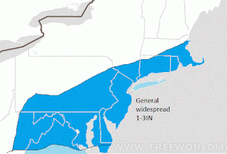
Finalized Snowfall Map For Friday
Below is my finalized snowfall map for Fridays light snow event. Things looked promising on Monday night when I posted my original map with had much higher amounts. The reason the amounts will be so light is that the two pieces of moisture that where supposed to merge before entering our area now will merge out to sea. The result will be a very cold light snow. I waited till today to change the map because I am not one to flip flop on an original forecast I make. Now that I have no model support I must however.
Since it will be so cold, snow ratios will be 20:1 so it will not take much liquid to give us an inch or two. Expect widespread accumulations of 1-3 locally 4 inches with this event. Event will start early Friday afternoon and last through the evening. Expect minor travel delays.
This winter has been hard for those who like big storms. First it was the lack of cold air and now the question will be since we should have the cold air through Feb will any big storms develop? I would like to think so, however it does not seem like the uncontrollable forces want it to snow heavy this year. The trend has been for these small rinky dink storms that give us a few inches. If in the next 3-4 weeks we do not see a major snowfall event then I think its save to say it was not meant to be this winter. Just looking at the climate pattern however, logic tells me we have a very decent shot in Feb.
We will have to wait till the Jury is out..more later
Since it will be so cold, snow ratios will be 20:1 so it will not take much liquid to give us an inch or two. Expect widespread accumulations of 1-3 locally 4 inches with this event. Event will start early Friday afternoon and last through the evening. Expect minor travel delays.
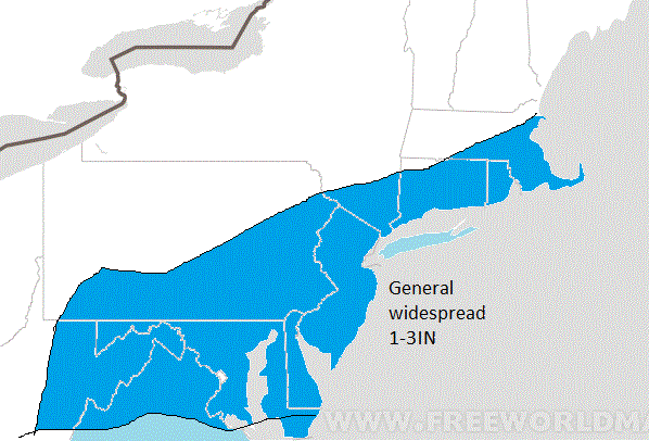
This winter has been hard for those who like big storms. First it was the lack of cold air and now the question will be since we should have the cold air through Feb will any big storms develop? I would like to think so, however it does not seem like the uncontrollable forces want it to snow heavy this year. The trend has been for these small rinky dink storms that give us a few inches. If in the next 3-4 weeks we do not see a major snowfall event then I think its save to say it was not meant to be this winter. Just looking at the climate pattern however, logic tells me we have a very decent shot in Feb.
We will have to wait till the Jury is out..more later
New Snowfall Map Coming Tonight- Much Lighter Amounts Likely
Now that we are only two days out the models are all converging on a common solution for this storm which is a light snow event. The two jet streams do not phase until the storm is out over the ocean so we will miss the heavy precip. I will post more tonight around 9pm..expect updates for Fridays travel conditions, if any.
Tuesday, January 22, 2013
Mid Day Models Sheering Storm to South
Just a quick note..today's model runs have weakened storm for Friday and sheered it south. I still have the Japanese and British model supporting my snow chart however, so I am not ready to change map. If I have to change it wnt be till tomorrow. Regardless snow will fall in any case it's just a matter of how heavy.
Monday, January 21, 2013
Monday 8PM: Initial Projection of Snow Totals for Fridays Event
I am beginning to look very closely at the snowstorm that will hit our area this Friday. We are still 4 days out but I am going to take a shot tonight at giving my initial best guess estimate for accumulations. Not all models are in perfect agreement on the track of this system. Some keep a tremdous amount of cold air all the way down into Delaware while others keep south jersey and Delaware out of the heaver snow. In general, the areas that get hit the hardest will see 4-6 locally 8 inches of snow. A lot of this will be due to the high snow ratios because of the cold air in place. Right now it looks like snow will spread into the region late Friday morning and continue into Friday night which could be an issue for the commute home Friday evening. Here is my initial estimate of what snow totals will be...i strongly recommend anyone who starts to read these totals check in daily as I may have to update the amounts as we get closer to the event...but here is the initial map...

Check in tomorrow for more updates

Check in tomorrow for more updates
Temp Chart for This Week
Read my last post for more detail on the next few weeks ahead but I wanted to post this temperature chart for this week to give an idea of what to expect every day. This is for Morristown, NJ but the whole state will be in this range. Disregard the top bar chart and click to make bigger.

Snow showers tonight, and a moderate snow event on Friday. More on this tomorrow.

Snow showers tonight, and a moderate snow event on Friday. More on this tomorrow.
Sunday, January 20, 2013
If This Next Week Is Not Winter Then I Don't Know What Is
Good morning. There is a lot to talk about in terms of the weather for the next week in particular, but the theme will stay constant for the next month. I will break this post into three segments- Temperatures over the next week, snow prospects for the next week, and finally some detail on the long term outlook.
So starting with temperatures: (click to make bigger)


So starting with temperatures: (click to make bigger)

What this graphic shows is what the high temperatures will be on Tuesday at 1 pm. Most of NJ will range from 20-25 degrees which is bitterly cold compared to what we are used to this winter. At night temps will drop into the teens. In fact it is probable that we will not see temperatures go above freezing all week! For North Jersey there is a chance highs on Thursday will not even break 20.
Hard to give exact details on temps two weeks out, but data suggests that it will be more of the same. I think this graphic sums it up best.

This shows how much below average temps will be for the week which translates to 5-8 degrees below normal for our region.
So we finally got the cold air so where is the snow? We have three shots at snow over the next 10 days. The first shot will be on Monday night and tuesday and generally should be light. Here is a projected radar simulation for Monday night.

As you can see snow showers will overspread the area as part of a clipper system coming in from Canada. Do not expect much in terms of accumulation, maybe a dusting to max of 2 in in some spots that get into an intense band.
Later in the week on Friday a moderate snow event looks possible for much of the region. There is a battle between if it is a NYC to Phili snow event or if the storm is warmer leaving the big cities out of the equation. At this point I have decent confidence that interior NJ will see snow from this ranging from 3-5 inches and near the cities will be the normal battleground. I am going to follow this closely and update as the week goes on. One of the more optimistic models the GFS shows the snowcover by Saturday like this....

This model is colder than some other which keeps Phili and NYC in the snow. I think this is too optimistic and the orange 4-6 inch line will be shifted a little north and west. Time will tell.
So lastly, what does the long term look like. I expect the cold temperatures to last through much of February varying in intensity. There is evidence that a large storm will effect the eastern part of the country after this week, so that will be worth watching. I am holding my ground on the fact that I think when it is all said and done will we see 2 large weather events on the east coast before winters over. Lets see how this all pans out.
In summary:
1. going to get very cold this week- and in many areas prob not ever go above freezing
2. light snow on Monday night (trace-2in)
3. chance at a moderate snow event on Friday (3-5in for some spots) keep checking in for updates on this
4. Chance at larger storm after this week and the cold air should last through most of Feb.
5. I think we will see a classic big storm before its all said and done.
Thursday, January 17, 2013
Thursday PM: Here Comes The Long Awaited Cold

Cold! That will be the story next week and most likely the remainder of January into most of Feb, So winter will finally arrive in terms of temperatures. Above shows temps for 1pm this Tuesday. Most of NJ is below 25 degrees that day and in general temps will not get above 32 all next week. At night we will see temps go into the teens. This is all due to true arctic air funneling down from Canada, a process that was rooted from the polar vortex of cold air spiting earlier this month. As I said expect the cold air to hold varying in intensity through February.
So where is the snow?
Well, Virginia and part of North Carolina is undergoing a snowstorm as we speak, so it is snowing just not in NJ. However this has good prospects for changing over the next few weeks. By the time we get into the 2nd week in Feb. I would be very surprised to not see a major storm system develop and effect our region. Its important to note that with the exception of last winter we have been very spoiled in the last few years. It is very hard to get a major snowstorm in excess of 12 in, so many factors have to come together all at once. Right now we have all the factors but one, which is an active southern jet stream to supply a northern wave energy dropping down from Canada much needed moisture. I think that eventually this will occur tho.
So bottom line what does this mean for everyone?
- For skiers, plan trips for Feb this year in the Northeast
- No major weather threats on the imminent horizon, but this can change on a daily basis so keep checking in
- Until then, expect very cold mornings going to work and heating bills to be higher than normal for Feb.
Im waiting for a storm to talk about so once I think we have a decent chance I will keep everyone updated. Until then, stay tuned.
Tuesday, January 15, 2013
4:30 Update on Upcoming Weather Event
Looks like most of the snow seen tonight will fall north of I-80 and any accumulation will be western Morris at higher elevations and Sussex county. Elsewhere it appears it will be very difficult to hold the cold air in place to produce any accumulating snow over an inch.
I am becoming very confident that we will see a big storm form in the weeks following this one (possibly a week from today!). The pattern is perfect and I will be posting frequently towards the end of the week on any potential threats. For those of you would like to go skiing this winter, plan your trips for end of Jan and Feb for best shots at optimum conditions.
I am becoming very confident that we will see a big storm form in the weeks following this one (possibly a week from today!). The pattern is perfect and I will be posting frequently towards the end of the week on any potential threats. For those of you would like to go skiing this winter, plan your trips for end of Jan and Feb for best shots at optimum conditions.
Tuesday Morning: Light Snow Late Tonight for NorthWest Counties
Good morning. A small wave of low pressure will enter our region late tonight through tomorrow morning bringing some accumulating snow to our northwestern counties. Expect accumulations of around 2=3 inches for western Morris county and all of Sussex county. For other areas in north Jersey expect around an inch or two. South of I-78 expect little in regards to accumulation. Snow will start late tonight and continue until late morning on Wednesday. Expect minor travel disruptions for areas where there will be over 2 in of snow. Here is a accumulation map:

No changes to the ideas I presented in video over weekend, so take a look for information on how weather will be over next two weeks. I will update more tomorrow.
No changes to the ideas I presented in video over weekend, so take a look for information on how weather will be over next two weeks. I will update more tomorrow.
Monday, January 14, 2013
Sunday, January 13, 2013
Wednesday, January 9, 2013
Wednesday 9 PM: Winter Will Strike Back
I have been commenting especially in the video I cut over the weekend that after this warm up we are in the middle of, winter is going to make a bold return. My ideas have not changed at all and in fact I think the atmosphere will be favorable end of next week for storm development. There are a lot of factors that are going to contribute to this big turnaround, but in a simple sense take a look at this..

Looks like a complicated map, but all I want to point out is look at the orange warm air over the southeast and the frigid blue and green arctic air charging down from Canada. This is going to set up a battle ground end of next week (cold air colliding with warm produces big storms) where we can see a storm develop and travel from the gulf up the east coast. I am not calling at storm at this point, but the potential is there.
I think we can all agree that's a big change from what the air feels like today, and that change will continue into Feb.
Stay tuned for updates on the upcoming cold and storm development as well as an upcoming video.
Monday, January 7, 2013
Monday 8PM: Watch Video For Pattern Overview; looking at the 18th for Possible Storm
I will post more on that this week. Things are starting to look interesting.
Sunday, January 6, 2013
Friday, January 4, 2013
Friday Noon: Updated Post Coming This Weekend on January Pattern
In a few words...enjoy the warm up next week, because it going to get cold late month!
Wednesday, January 2, 2013
Wednesday Night: Cold Shot Ends Next Week
Happy New Year. This week will remain very cold with highs not getting out of the 30's and lows entering the teens for north jersey. There is a slight chance of a storm forming for Sunday and Monday but I would not say that is likely at this point. Past this week, we will see a seasonal warm up for most of the nation before more brutal cold is likely to return by the middle to end of January. Before I get into detail on this, lets look at totals from the last snow event on Saturday:

This is the only map I could get, but it shows a general area of 3-4 inches of snow for most of north Jersey which higher amounts up in Sussex county. Not a bad moderate event by any means. I measured 4 inches in Morristown NJ. We are generally above average for snowfall this time of year which is not a bad start to winter. We have yet to have a big storm, but if you like snow we have at least seen it on several occasions.
Right now there are several signs that the pattern will reverse for next week and the week following leading to some mild weather for our region. This is not uncommon for January and is referred to as a January thaw. We can see this in the graphic below (from weatherbell.com)..

However, as this "thaw" is occurring as the upper levels of the atmosphere over the North Pole are warming. When the upper atmosphere in this region warms, it compresses the lower levels underneath and results in the cold air locked up in the pole to collapse and flow out of the polar region. This usually results in cold outbreaks for the USA. Generally there is a 2-3 week lag time before this happens hence why it will be warm over the next two weeks. Thus, expect our next shot at cold and snow to have the best chances of occurring towards the end of the month into February.
That does not mean a storm can not sneak up on us in the meantime, in fact as I mentioned there is a outside chance a storm might want to organize itself on the east coast on Sunday night. However, this will be much more likely once the atmosphere reloads in a few weeks.
I think we are on pace for a winter that will see frequent snow events and potentially 1 or 2 major events before season end. Keep checking in.
This is the only map I could get, but it shows a general area of 3-4 inches of snow for most of north Jersey which higher amounts up in Sussex county. Not a bad moderate event by any means. I measured 4 inches in Morristown NJ. We are generally above average for snowfall this time of year which is not a bad start to winter. We have yet to have a big storm, but if you like snow we have at least seen it on several occasions.
Right now there are several signs that the pattern will reverse for next week and the week following leading to some mild weather for our region. This is not uncommon for January and is referred to as a January thaw. We can see this in the graphic below (from weatherbell.com)..
However, as this "thaw" is occurring as the upper levels of the atmosphere over the North Pole are warming. When the upper atmosphere in this region warms, it compresses the lower levels underneath and results in the cold air locked up in the pole to collapse and flow out of the polar region. This usually results in cold outbreaks for the USA. Generally there is a 2-3 week lag time before this happens hence why it will be warm over the next two weeks. Thus, expect our next shot at cold and snow to have the best chances of occurring towards the end of the month into February.
That does not mean a storm can not sneak up on us in the meantime, in fact as I mentioned there is a outside chance a storm might want to organize itself on the east coast on Sunday night. However, this will be much more likely once the atmosphere reloads in a few weeks.
I think we are on pace for a winter that will see frequent snow events and potentially 1 or 2 major events before season end. Keep checking in.
Subscribe to:
Posts (Atom)