Friday, November 30, 2012
Friday 12 PM:Not Many Changes From Prior Post
Looking at latest guidance, things look on track as I originally discussed a few days ago. Middle to the end of December looks very cold and active and there is still a chance a storm can develop between Dec 6-10 time frame, but at this point I am making no predictions. Once I have a chance to review more modeling this weekend I will update this blog.
Wednesday, November 28, 2012
Looking Calm Till Mid Dec. Where Things Can Get Wild, Maybe a Surprise Along the Way
Good Afternoon. I have been evaluating the weather pattern and also some of the wide scale climate signals I look at such as the trend in the NAO, AO, PNA (see basic lingo defined page for explanation) along with some long term modeling that shows potential temperatures and precipitation for the month of December. What I can say is from mid December on watch out, things look like they will become very active giving us increased chances of a white Christmas. The best way to show this is graphically so here are some of the outputs I have been evaluating.
 source:weatherbell.com
Above you can see what the GFS model is predicting for temperatures in the Mid December time period. Notice along with the below normal temps shown on the east coast, there is also an enormous amount of cold air building up in central and western Canada. This is called the source region and once the jet stream buckles it allows all of this cold air to flow into the USA similar to a dam breaking. Usually when I see this along with some other signals I will show you in a second It tells me cold air is on its way. Now lets take a look at the NAO index.


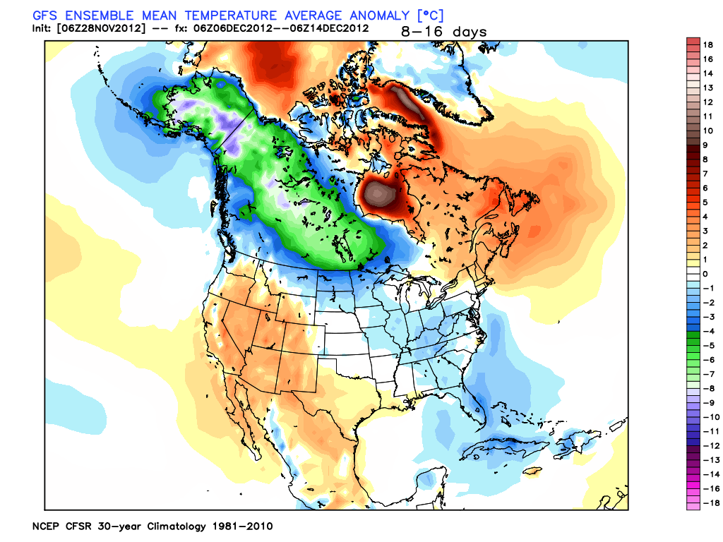
Above you can see what the GFS model is predicting for temperatures in the Mid December time period. Notice along with the below normal temps shown on the east coast, there is also an enormous amount of cold air building up in central and western Canada. This is called the source region and once the jet stream buckles it allows all of this cold air to flow into the USA similar to a dam breaking. Usually when I see this along with some other signals I will show you in a second It tells me cold air is on its way. Now lets take a look at the NAO index.

source:weatherbell.com
The blue line is what the observed value of the index was (already occurred) and the black line shows the forecast for this pattern. The NAO is very low right now, will rebound entering the beginning of December then crash again heading into mid month. This gives the East Coast a good shot at a favorable Storm setup mid month. Many times north east storms occur when this pattern is in its transition phase meaning when it is on the move from negative to positive. You can see from the 1st of December to the 6th of December it is making this transition. Which gives us the potential to see a storm develop around the December 6th time period. Here is what the upper atmosphere will look like at that time.

source:weatherbell.com
Notice the trough over the east coast with the ridge in the west (blue vs orange). Now modeling does not have a storm at this time just has a strong front coming through, but I wanted to show how there is a chance but I am making no perdition at this time.
Finally, lets put all of this together and have a little fun and look at what the long term climate model is showing for snow cover for the middle to end of December. This is far to overdone, but It is exciting to see none the less and shows that the idea of a white Christmas is on the table. Check this out, each box represents the same model but run with a few different variables changed as you can see much of country is covered in snow. Again this is overdone, but can provide a clue...

source:weatherbell.com
In summary, things will warm up and quite down over the next week. All eyes are on mid Month where we will have a favorable atmospheric setup for cold and stormy conditions giving us a chance at a White Christmas. If there will be any action before this period it will occur around the 6th of Dec. Stay Tuned.
Tuesday, November 27, 2012
Snowfall Totals
Below is the link to the recorded totals around the state of NJ. As seen, totals range from 2-4 inches and locally 5.
Click For Snow Totals
Accumulating Snow Will Wind Down Soon
Looks like we received the 2-4 locally 5 inch amounts I have discussed over the last two days, and hit the lower end of my original 3-6 inch forecast. The snow will start to wind down over next few hours from west to east tapering off to light snow then flurry's. Keep checking in for new posts on upcoming December pattern.
 source:accuweather.com

2-4 Inches Today
Snow will start soon and last until this evening, accumulating the most between late morning and late afternoon. Total accumulations will be 2-4 inches with locally 5 in areas of higher elevation. My original forecast was for 3-6 inches four days ago, so we will hit that range but on the lower end. Enjoy the snow
Monday, November 26, 2012
Monday 10pm: New NAM Model Has More Snow
The latest run of the NAM model has come in and show an area of 4-6 in of snow over our area which is in line with my original forecast of 3-6. This model has been the most extreme in the last 24 hours but has not backed off on its latest run. Its very interesting to see how even with in 12 hours the models still are catching up to the development of this storm. Snow will start tomorrow morning and last until dusk and I am sticking with the 2-4 in forecast as posted earlier.
On a side note: the National Weather Service forecast as of 10 pm has rain changing to snow with accumulations of an inch possible. Its funny how behind the ball they always are. That's one of the reasons why I created this blog.
On a side note: the National Weather Service forecast as of 10 pm has rain changing to snow with accumulations of an inch possible. Its funny how behind the ball they always are. That's one of the reasons why I created this blog.
Updated Snowfall Forecast

source:weatherbell.com
We will see snow tomorrow but it will be on the lower end of my original forecast of 3-6 inches. Right now this looks like a 2 to 4 inch event across eastern PA and New Jersey. The GFS model snowfall projection is the closest to my prediction as seen above. This has been a very tricky weather situation to keep up with. Yesterday the models totally backed off on this storm and now today they are starting to come back and we are less that 18 hours away. This shows how even with the best computer technology the weather still is very hard to predict and can change on a dime. In any event, following this storm things will warm up for a little but December is on track to be a cold and stormy month.
Less Snow Expected
Good morning, a lot has changed in the last 24 hours. The trend that was holding up all week has broken and the models have now converged on fragmenting this storm resulting in a much weaker solution. Snow will still fall but accumulations will be a lot less. It looks now like we can see a dusting to an inch of accumulation, with a outside chance at more (only one model has several inches falling). I am surprised that this storm did not form as originally expected due to the pattern we are in, but it shows how complex the weather is. Sometimes the modeling does an excellent job, and other like in this case it has a very hard time piecing the atmosphere together. If something changes with the afternoon updates I will make note but as of now I am going to have to stick with what the models are saying since we are only 24 hours away. Keep checking in because I am going to be talking more about what to expect in December when it comes to winter weather.
Sunday, November 25, 2012
Might Need to Update a Few Things Later
Alot has changed in the last 24 hrs, I will update later this afternoon. All modeling has flipped out to sea with the system and reversed the trend we have seen for a week. I do not want to change my forecast until tonight's runs that will account for the primary source of energy making landfall in the pacific northwest before it begins its journey towards the north east.
Saturday, November 24, 2012
Upcoming Storm Snowfall Totals and Timing
Good afternoon, this morning and afternoon's runs of the modeling has come into greater agreement and now most guidance shows a storm developing off the mid Atlantic coast Tuesday night. This will be a moderate 8-12 hour snow event for areas west of the I-95 corridor with accumulations ranging from 3 to 6 inches locally 8. Areas east of I-95 will see snow but the accumulations will be less. Here is the snowfall forecast from the GFS model and I like the output.

source:weatherbell.com
For those of you who have been following this blog now can see how I plan to forecast these events very far in advance based on large scale weather patterns in the northern hemisphere. This storm did not exist on the models until just a day or two ago but I wanted to show how it is possible to speculate and predict an event like this based on a few key variables long before any modeling picks up. You can see how I did this in my older posts. That really is the purpose of this blog, to keep everyone ahead of the curve when it comes to these events, and even tho this will not big a major storm, when that time comes I will be on top of it. If you noticed, the press and weather media did not start talking about this event until today. There are going to be many times where I am wrong, but at least this can be one source that people can read where a prediction is made and not changed based on every run of the models. I will post a little as we run up to the event and note if there are any significant changes from my forecast make today. I think we can see based on the temps today winter is here.
Friday, November 23, 2012
No Model Agreement on Storm, Multiple Solutions
The weather forecasters out there have started to mention the treat of a storm next week as I have now for a full 6 days. However, the model agreement on this system is some of the worst I've seen. The European just has a cold wave coming through the area, while the GFS now has more of a moderate snow event. This is going to come down to the wire and I am sticking my ground that we will see accumulating snow for our region. I find it hard to believe with the NAO that is in place along with this upcoming cold shot and ridging to our west that a storm will not develop. Keep checking in because I will continue to monitor this situation and try to get more detailed on track and precipitation amounts by tomorrow. Also I will show some more graphics with the models. On another note, the cold is here starting tomorrow. Temps will be in 40's and 30's all week, so bundle up. Thats all for now.
Update this Afternoon Coming
I will update later today about the storm for next week so keep an eye out. However, in short I do not have many changes, the storm will def not cut up into the lakes and the modeling is still having a hard time with handling the two pieces of energy that need to come together. I will illustrate all of this later..
Thursday, November 22, 2012
NAO Crashes Next Week,Still Bullish on Storm, and Increasing Chances of White Christmas
Happy Thanksgiving everyone. The next 10 days are going to be very exciting weather wise. The NAO (see basic lingo defined) is now looking to crash down to levels close to where it was during hurricane Sandy. This means we should see a very dynamic trough develop middle of next week which would allow the upcoming storm to form along the coast line. Modeling is still all over the place, some take the storm west of us, some take it out to sea however, I see no reason to change my prediction at this time. I am still bullish on the fact that a stronger colder storm will evolve. In any regard it is looking more and more like we will have a cold December, which will increase our chances for a white Christmas Take a look at this invasion of cold air on the models next week which I believe is a sign of things to come all month (blue and green are cold)...
 source:weatherbell.com
Usually a setup like this produces snowstorms and given the track the the storms this fall have taken, I find it hard to believe this will end up being a weak frontal system as some modeling is indicating. We will have to wait and see. Enjoy the day everyone.

Usually a setup like this produces snowstorms and given the track the the storms this fall have taken, I find it hard to believe this will end up being a weak frontal system as some modeling is indicating. We will have to wait and see. Enjoy the day everyone.
Wednesday, November 21, 2012
Wed 3pm: New Euro Is In- Much Colder Solution
The afternoon run of the European model has reverted back to a colder solution as it showed yesterday. For those of you who have been following this blog, now you see why I am not going to flip flop my opinion on what is going to happen with every run of the models. It is obvious at this point that they are having a very difficult time handling the timing of the energy and how the trough is going to set up. But it terms of setting up a trend, I am seeing a trend for a colder storm compared to what every other forecast out there has right now. We are still 7 days away and its very rare this time of year to have a snowstorm for our area on a model 7 days out. Usually its not until a few days before that they will begin to pick up on what is really going on. I am beginning to get bullish on this outcome because of the active pattern we have seen all fall on the east coast and the strong negative NAO that will be in place. More later..
Storm Imminent, Will It Be Rain, Will It Be Snow? Lets Take a Look
Good morning, the storm that I have discussed over the last 5 days is coming. Both the European and GFS modeling are in good agreement and on their current track have the low passing just to the west of our area which would make way for more rain rather than snow. The picture below shows the GFS model forecast for the storm, notice compared to yesterdays run it is more more stronger with this system printing out a 988mb low.
 source:accuweather.com
However, not much has to change for this to be a more frozen precipitation event. All we need is to have more ridging in the west to dig this trough further southeast and we are looking at a snowstorm for our area. Right now no modeling is showing this solution and just have a front coming through with a upper low riding along the front, but they are right on the brink. If 7 days out I have to go on a limb and predict were the snowfall will be, I like this projected snowfall path shown below but moved about 30 miles southeast....

This basically puts extreme Northwest NJ and the majority of New England in the accumulating snow zone. Over the next 7 days the models are going start waffling with every run but I will be looking for a trend to develop. I will post more on this tonight after I can take a look at this afternoons trend in modeling. Right now tho I think we are seeing a favorable trend for this to become more snow for our area...stay tuned

However, not much has to change for this to be a more frozen precipitation event. All we need is to have more ridging in the west to dig this trough further southeast and we are looking at a snowstorm for our area. Right now no modeling is showing this solution and just have a front coming through with a upper low riding along the front, but they are right on the brink. If 7 days out I have to go on a limb and predict were the snowfall will be, I like this projected snowfall path shown below but moved about 30 miles southeast....

source:weatherbell.com
This basically puts extreme Northwest NJ and the majority of New England in the accumulating snow zone. Over the next 7 days the models are going start waffling with every run but I will be looking for a trend to develop. I will post more on this tonight after I can take a look at this afternoons trend in modeling. Right now tho I think we are seeing a favorable trend for this to become more snow for our area...stay tuned
Tuesday, November 20, 2012
Tuesday PM: Detailed Post Tomorrow on Upcomming Storm
I will go into more detail tomorrow of what I believe will unfold with the storm next week. Since Saturday I saw the potential for this and I want to wait for a few more model runs before I begin to speculate.
Tuesday Morning: European and GFS Now Showing East Coast Threat I've Hinted At!
Check this out:
European Model middle of next week:

source:accuweather.com
GFS Model middle of next week :

Now you all can see the difference one run of modeling can make and why I mentioned last night only a few factors had to chance for storm to form over east coast. We go from a storm in Chicago to storm in NYC in one model run. Now this blog will get interesting as you will all see the evolution of whether or not this situation will evolve and the reasons for the final outcome. I have been hinting at this happening since Saturday and once we get within 7 days I will start to give you my projected chances at a storm like this coming to fruition. Now will usually start the normal back and forth of the modeling where one day its on the map the other day its not. Stay tuned!
Monday, November 19, 2012
Monday Night: The Cold Is Coming and Keep an Eye on Middle of Next Week
Good Evening, I want to take you through what I believe will be the progression from this weekend on...


source: weatherbell.com
Below Normal Temps Days 5-7 Even Colder Solution 7-14 Days out
In addition a storm will form in the US during this same time period. The question will become will it form near the great lakes region or will it form on the east coast. But first let's look at what the upper atmosphere will look like during this same time period...
 \
\
s
source: weatherbell.com
Notice the blocking over Greenland (negative NAO) and over Alaska (red regions), this is what is allowing the jet stream to form a trough over the majority of the continental US during this time period. Blue represents lower "heights" which basically means heavier air which translates to colder air. Now the question is how and when will a storm form given these conditions. Right now longer term modeling shows very strong storm turning up into the lakes next Wednesday..

source:weatherbell.com
This storm track will depend on a variety of factors including how those red blocking regions over Greenland and Alaska end up forming over the next week. If we see the blocking over Alaska progress more to the north west, that will allow this storm to potentially come together close to the coast line. I am not ready to predict a storm on the east coast, but I do see a slight chance how the modeling can arrive at this solution. What I am confident in is that there will be a storm somewhere between Chicago and New York. As of now Chicago is ground zero. This will be interesting to look at over the next few days. In any regard, after this week the cold is coming so get ready for winter..more tomorrow..


source: weatherbell.com
Below Normal Temps Days 5-7 Even Colder Solution 7-14 Days out
In addition a storm will form in the US during this same time period. The question will become will it form near the great lakes region or will it form on the east coast. But first let's look at what the upper atmosphere will look like during this same time period...
\s
source: weatherbell.com
Notice the blocking over Greenland (negative NAO) and over Alaska (red regions), this is what is allowing the jet stream to form a trough over the majority of the continental US during this time period. Blue represents lower "heights" which basically means heavier air which translates to colder air. Now the question is how and when will a storm form given these conditions. Right now longer term modeling shows very strong storm turning up into the lakes next Wednesday..

source:weatherbell.com
This storm track will depend on a variety of factors including how those red blocking regions over Greenland and Alaska end up forming over the next week. If we see the blocking over Alaska progress more to the north west, that will allow this storm to potentially come together close to the coast line. I am not ready to predict a storm on the east coast, but I do see a slight chance how the modeling can arrive at this solution. What I am confident in is that there will be a storm somewhere between Chicago and New York. As of now Chicago is ground zero. This will be interesting to look at over the next few days. In any regard, after this week the cold is coming so get ready for winter..more tomorrow..
Monday AM: No Changes
Good morning, I have no major changes and am staying with the same theme: Pleasant Thanksgiving week,cold shot coming this weekend, and a favorable atmospheric setup for storm development middle of next week into December with below normal temperatures...more later
Sunday, November 18, 2012
Sunday 11 am: Storm Stays Offshore, Looking at 10 Day Peroid
The storm that I mentioned could effect the coastal areas in the form of some minor wind and waves will stay far enough off shore to not cause any major concern midweek.

source:accuweather.com
Right now my focus is to take a look at the weather pattern for the 7-10 day period. Before then, the weather will be beautiful all week with temps in the low 50's and sunny skies so no concern there. However, we will all notice a chill down next weekend (high temps in the 40's) as the next cold front swings through our area. It is after next weekend that I am keeping my eye on a favorable setup for a possible system developing along the eastern seaboard. Favorable does not mean there is currently the threat of a storm I am just stating that we will have the cold air in place and the upper atmosphere conditions needed that could favor the development of a storm. In any regard we are still on track for a cold start to December. I will continue taking a look at this trend all week and post with any updates or changes.
Saturday, November 17, 2012
3pm: 1st Week of Dec Temps & Negative NAO
The below map shows the departure from normal that temperatures are forecast to be entering the 1st week of December. Blue is below normal, red is above normal. As of now looking like departures of over 2 degrees below normal. In addition it looks like we will be entering a negative phase of the NAO (see basic lingo defined tab at top of webpage for definition) which could set us up for a very active December for winter weather.

The red over Greenland is showing the negative NAO which means a strong trough should develop on the east coast during that same time period. Red represents higher pressure and blue represents lower pressure. Areas of blue usually mean troughs in jet stream and areas of red are ridges.

source: weatherbell.com
Looking Ahead to Thanksgiving Week and Beyond
Welcome everyone, this will be my first inaugural post on this blog. Looking out the next 7 days through Thanksgiving week, at this point it appears we will have quiet weather across the east coast. There will be a strong storm forming offshore by mid-week and this can produce a minor problem for coastal areas hit hard by sandy in the form of higher waves and some wind crashing into a now unprotected shore line. Normally this would not be a big deal, but because of the destruction we have seen to our beaches it now creates more of an issue. Do not rule out 8 ft waves Wednesday night through Thursday and wind gusts along the beach up to 30 mph. However,at this time I do not anticipate any major rain or snowfall from this event. Modeling has trended more westward over the last few days but I believe it will not effect our area in a major way, just cloudy conditions. We are still 5 days away so if I change my view on this it will be by tomorrow afternoon. Inside of 4 days it will be a habit of mine to stick with any forecast I create. Stay tuned tho because if this modeling continues to trend west we could be having a different discussion....more later
In terms of post Thanksgiving we are looking to have a cold and stormy start to December which will make for some interesting posts on this blog. Stay tuned for more details.
In terms of post Thanksgiving we are looking to have a cold and stormy start to December which will make for some interesting posts on this blog. Stay tuned for more details.
Subscribe to:
Posts (Atom)