WINTER OUTLOOK 2023 IS NOW LIVE

The 2023 Winter Outlook

Tuesday, September 24, 2019

Tuesday Update: Seasonable to Above Normal Next 10 Days

Good morning. Fall may have started on Sunday, but it sure didn't feel like it yesterday with temperatures that approached 90 degrees in many areas. 

The heat breaks over the next few days with cooler air now over the region...

Temperatures will be in the 70s today through the early weekend.

Things then look to heat up again as we approach next week with a big western trough and powerful eastern ridge...

This will bring temps back into the upper 80's. Notice the cold air to the west. 

The first snows of the season will fall there...


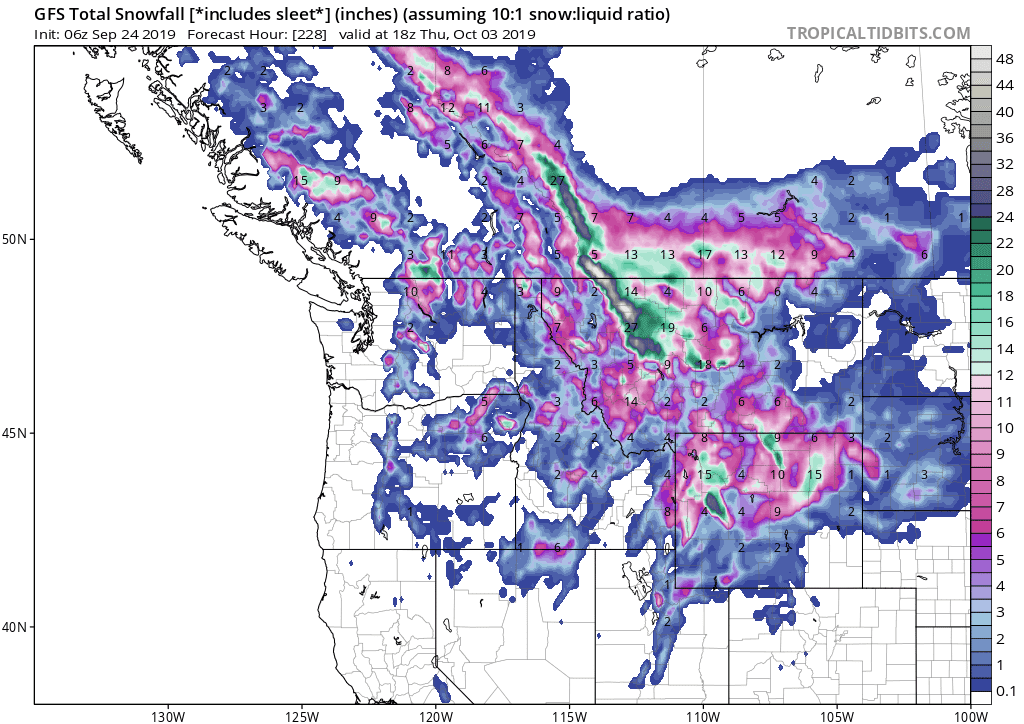
Pretty crazy difference in weather between the east and west next week.

In the long range the jury is still out on where this pattern goes. I really would like to see this western trough start to break down over the next month. If we continue to see the western trough reappear, then it may be a clue to where this winter pattern is going.

My forecast will be out on October 15th. I still am very uncertain the direction I am going to go this year. It is all going to come down to what evolves over next 4 weeks. 


Tuesday, September 17, 2019

Tuesday: Cool Temps Till Weekend

As many toast in some late summer heat, the Northeast will get fall relief this week as a sneaky high pressure system from Canada funnels in cold air...


Temps will be in 70s for Mid Atlantic and 60s for northern New England for highs. Lows at night will feel quite chilly with some frost in Maine.

Things then warm up by the weekend to a little over average.

Wednesday, September 11, 2019

Wednesday: Last Gasp of Summer

Good morning. Short post today as the next several weeks will be spent working on my 2020 winter outlook.

The last summer like surge of heat will be arriving over next week or so...

This time of year all that means is daytime highs will reach into mid 80s for some spots. At night the lows will bring a chill back to the air for most areas to the north. The sun is not strong enough this time of year to keep it hot for prolonged periods of time.

For the most part summer is over. We now evaluate the step down pattern into winter.

After this spurt of warmer than normal temps next 7-10 days, models are picking up on a potential big autumn cool down... in about 10-15 days...


If this verifies this will be the first noticeable chill of the season. The thing we will have to evaluate is where does this center itself. It very well can center over the Mid-West.

Something to keep an eye on over the next week.


Enjoy the warm weather.

Thursday, September 5, 2019

Thursday Dorian Update

Good morning. Dorian is currently a very strong Cat 3 storm with winds over 100mph. It is making its move up the coast...

You can see it has an eye structure still and well developed overall.

As this moves up the coast areas from coastal SC to NC will see heavy rain, hurricane force winds and a surge of water which will cause problems through Friday.

Here is updated NHC cone...


The updated wind gust swath is below...notice the coast gets in close to core of highest winds...

As the storm approaches with these winds, water piles up which causes the storm surge.

By this weekend the storm is off mid Atlantic coast...


By then, it will just be some gusty winds and showers for areas near coast. The Cape may see more than that and we have to watch closely how this tracks.

That's all for now.

Wednesday, September 4, 2019

Wednesday Update: Dorian Now Heading to East Coast

Good morning. Granted, it may be weaker than before but we still have a powerful Cat 2 hurricane that is now expected to impact coastal areas of the south. The time frame is tomorrow through Friday.

The storm is not as impressive as it was a few days ago on the satellite, but as I said it is still not something to take lightly...


Latest track takes the center just along the coast...


This should be a Cat 1/2 by then but will still pack wind gusts over 100 mph on coastline and major flooding issues especially in areas like northern GA and SC coasts. This is due to the position the storm is approaching from and how it will pile up water.

Here is the updated wind gust swath...


This has shifted west from yesterday and most models are converging on this outcome.

NHC Updated Cone...


This is not to be taken lightly. Coastal areas are going to see major impacts from this.

More to come. 

Tuesday, September 3, 2019

Tuesday Dorian Update

Good morning. Dorian currently sits just off the coast of Florida and has started to make its turn north...

In its wake so far it has completely destroyed parts of the northern Bahamas. The storm was stalled over those islands for over a day at Cat 5 strength. 

Very sad images to see..


Lets hope we hear about some good recovery efforts down there.

The storm is now weaker but still a powerful Cat 3 with winds over 100 mph. It is expected to just track off the US coast over next few days and make potential landfall in the south...

Florida will not see  a landfall from this despite how close it is.

Areas from the Charleston to Outer banks will see the high impacts from this. There is a decent probability the storm makes landfall in that area. We will be watching this closely.

Regardless, even if the storm stays just off the coast the impacts are still going to be high.

Here is a projection of max wind gusts which gives a good idea of the track...


You can see how the hurricane wind gusts are expected to just skirt the coast. Any small changes to track can have big impacts here. 

The NHC has updated their cone...


Stay tuned, this is still a very dangerous storm and preparations need to be made now for areas in the south.


Sunday, September 1, 2019

Sunday Update: Dorian is Now a Cat 5 Monster


Good morning. Hurricane Dorian continued to strengthen overnight and now is about to lay  devastation on the northern Bahama islands. Winds are currently sustained at 160 mph in the core with gusts that are even higher. You can see the tight wound up core of this storm from the loop above. The dark red and brown colors indicate explosive convection (thunderstorms).The symmetry is incredible.

The storm is forecast to linger over northern Bahamas next 24 to 30 hours...this will be a disaster


Models then all turn this north before landfall in Florida. This is still way too close for comfort though...


At this time I would be on high alert for areas on the coast of North and South Carolina.

Although the storm will weaken from a cat 5 as it makes its turn north, there can still be some major impacts for coastal areas of the east coast. We can not pinpoint yet the exact details until the storm makes it turn north in a few days.

All we can hope is it take the more outside track and there are limited impacts to the United States. Regardless, the northern Bahamas are about to see what could be the worst hurricane to ever hit them. Lets hope its not as bad as feared.


More to come.