Will comment more tomorrow but there will be a wave of snow moving through the region Monday morning. For metro areas I expect accumulations mostly on non pavement surfaces 2 to 3 inches.
There should be some enhanced amounts in the interior especially at high elevations. 3 to 5 might be possible there but again that is not widespread.
Overall from CNJ to southern New England a 2 to 4 inch snowfall on non pavement mostly with the travels impacts more focused on higher elevations of NW NJ, PA etc.
More to come on this. My post from yesterday has some further details.
Saturday, March 31, 2018
Friday, March 30, 2018
Friday Update: Winter Just Doesn't Want to Quit
Good evening and Happy Easter weekend! It may be spring and it may be Easter, but winter just does not want to quit this year. The mild temperatures today will give way to a chill in the air by this weekend and then things start to get very interesting.
Over the next 10 days or so the area will be hit with waves of cold Canadian air as it gets released from central Canada. As this occurs there is the chance for snow in many areas starting with Monday morning. As we then approach the end of next week as crazy as it sounds, there could be the threat for an even bigger storm. Of course given its spring you can seek some comfort that snow is fairly rare but when the pattern fits, you need to keep an eye out.
It all starts with the colder than normal air currently pooled in Canada...
 The purple shows below normal temperatures and provides a source region for cold intrusions into the eastern United States.
As we get to the end of the weekend some of this cold starts to move in...
 You will notice a chill in the air arrive and on its approach a wave a low pressure could develop Monday morning causing snow...
 The pattern certainty supports this but not to worry, the impacts shouldn't be too bad if this happens. Maybe some slick roads in the morning and all melted by the afternoon. 1-4 inches possible with this. I will comment more this weekend.
As we then move on towards the end of next week the next big and possibly more impressive shot of cold air arrives....
 I would look to interior New England at the higher elevation to potentially see snow as this cold front moves in Wednesday...
 We now enter the period of concern. In the wake of this front moving through there is a chance the cold air becomes locked in ahead of the next approaching storm system...

Looking above you are seeing the upper air setup as we head into next weekend. Few things to notice here:


Over the next 10 days or so the area will be hit with waves of cold Canadian air as it gets released from central Canada. As this occurs there is the chance for snow in many areas starting with Monday morning. As we then approach the end of next week as crazy as it sounds, there could be the threat for an even bigger storm. Of course given its spring you can seek some comfort that snow is fairly rare but when the pattern fits, you need to keep an eye out.
It all starts with the colder than normal air currently pooled in Canada...

As we get to the end of the weekend some of this cold starts to move in...


As we then move on towards the end of next week the next big and possibly more impressive shot of cold air arrives....


Looking above you are seeing the upper air setup as we head into next weekend. Few things to notice here:
- Cold air is established and potentially locked in by block and vortex near eastern Canada
- We have two sources of energy one diving through the northern plains and the other coming potentially from the south (two red X's)
- Potential aid in this coming together due to a ridge flexing on the west coast
We do not know exactly how this will play but this is as good as a set up as you will ever see to produce a winter event in April come next weekend.
Right now the models are flirting with the idea...
GFS...

European...

Lets see what happens the potential is there.
Monday, March 26, 2018
Monday Note: Some Warmth, One Last Cold Shot Possible
Good morning. A quick note today. As we are now in spring, we start the climb up to pleasant temperatures and nice weather. However, with the atmospheric setup think year there will be a few bumps along the way. There is still alot of cold air up in Canada that needs to be watched.
In the short term, temps will warm up nicely towards the end of this week...

As we move past the Easter holiday however the cold air in Canada may try to spill south next week at one point...
 It's an impressive pool of cold and given the pattern I see we would have to keep an eye out for one last winter type event by the end of the 1st week of April. History is on our side and the chances are still low, but the pattern could support it.
That's all for now.
In the short term, temps will warm up nicely towards the end of this week...

As we move past the Easter holiday however the cold air in Canada may try to spill south next week at one point...

That's all for now.
Thursday, March 22, 2018
Thursday: The Aftermath
Well that was interesting yesterday. We did not see the widespread 8 to 16 inch totals as my final forecast had but this storm sure didn't want to quit last night. It was still snowing here in Morristown at 3am! We ended up with 6 or 7 inches here which was low compared to others.
Looking at all the snow reports below (click to enlarge), my 6 to 12 would have been more appropriate with local amounts over a foot...

 Regardless, this storm was no spring chicken. It just did not live up to the hype of my final update Tuesday night. I don't want to pull a trick and cherry pick a few high totals and act like I was on point.
I appreachiate all the nice comments and all the folks who enjoy following. This is just a hobby of mine but the blog and interaction with followers makes it much more fun.
Winter is now on its last leg but we are not in the clear until April this year.
Stay tuned.
Looking at all the snow reports below (click to enlarge), my 6 to 12 would have been more appropriate with local amounts over a foot...


I appreachiate all the nice comments and all the folks who enjoy following. This is just a hobby of mine but the blog and interaction with followers makes it much more fun.
Winter is now on its last leg but we are not in the clear until April this year.
Stay tuned.
Wednesday, March 21, 2018
6PM Update: Yup, Its a Bust...@weatherwilly takes it on the chin
As many of you prob assumed already this storm is a big bust for most but not all areas......
 I blew it on this one folks. After looking at the latest observations this thing will not throw much heavy precip back onto land tonight for most areas. What we will get is just a light to moderate non eventful snowfall with maybe a few more inches of accumulation. I wanted to be cautious with this storm but went against my instinct and folded to the impressive snow printouts the models had last night. Lesson learned!
There are areas that are seeing 8+ inches of snow (PA did very well with this) and you will see reports of 12 inches maybe even a little more but localized reports do not justify a forecast. We are not seeing widespread impressive accumulations.
Despise the fact every major model was showing an impactful storm, the reality was this storm just did not tighten up enough on a large scale. What I mean by that is the energy transfer from the low out in the ohio valley to the low off the coast was way too stretched out and not compact. This means the best dynamics for heavy snow stayed off shore.
Snow will continue through midnight for many areas but as I said it will not too heavy. Expect a few more inches before this is all said and done.
I hate to end the year with a big swing and a miss but you live and you learn. I really took the bait last night.
Things will stay on the chilly side into April this year and yes it could snow again but we are really testing the extreme of climatology this late in the season. Lets see how things go.
I appreciate everyone who has been following and i'll do better for you next time!
4pm Update: This Has a While to Go
I have seen many reports ranging from 2-8 inches so far region wide.
Current radar shows our coastal low taking over...

As this coastal low intensifies over next few hours heavy precip gets thrown onshore. The model below shows this valid 8pm...

I highlighted potential heavy snow bands. The observations to me right now support to double current amounts for areas within the vicinity of these highlighted regions. This means what ever you have on the ground now expect more of the same next 8 hours.
Eventually this all slides east and the storms ends around midnight...
 Long island may get blasted on the departure of this storm along with CT if a big band develops.
Stay tuned I will have one more update a little later.
Current radar shows our coastal low taking over...

As this coastal low intensifies over next few hours heavy precip gets thrown onshore. The model below shows this valid 8pm...

I highlighted potential heavy snow bands. The observations to me right now support to double current amounts for areas within the vicinity of these highlighted regions. This means what ever you have on the ground now expect more of the same next 8 hours.
Eventually this all slides east and the storms ends around midnight...

Stay tuned I will have one more update a little later.
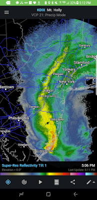
Noon Update: Storm Gets Going As Afternoon Wears On, Some Changes
The storm is now well underway for some and for others it has been sparse. The snow will pick up in all areas as the afternoon wears on and continue into this evening. However, this storm will not be as impact as feared last night. What that means is my final forecast issued yesterday morning (6-12") was more appropriate than my update last night (8-16").The result is many areas see between 6-12 inches not 8-16 inches of snow. Yes, there will be local amounts that still do go over 12".
So what happened? Despite the aggressive outputs from almost every model last night, the reality of the situation is the low pressure system is not going to wind up as tight as originally thought. We have a broad elongated trough. Below you can see the closed circulation at 18000 ft in the atmosphere (upper low) trend to be more off the coast...

This small change as projected and now as being observed will cause the heavier snow bands to be more east and even off shore.
The current radar shows snow forming and this will fill in to moderate snow by the middle of this afternoon...

Again, this still will be a moderate to heavy snowstorm and the snow will not stop till late tonight.
So I jumped the gun last night and should have stuck with my original ideas on this storm. The models got way too over amped last night.
Its March 21st and this still will be one of the more impressive late season storm but not anywhere close to storms like in March of 1958.
I will have another update by mid afternoon to see how things are going.
7am Update: Storm Starting Up
Good morning. No changes to my forecast with a range of 8 to 16 inches for many areas...
 Snow is now starting to spread into the region, but this really does not get going toll later this morning...
 By late morning, accumulations start to become noticible as the low starts to crank off the coast...
 By mid afternoon I expect snow to really start piling up...
 By this late tonight we are still snowing...

Get your stuff done this morning. Things will not be in good shape come afternoon. Eveything seems on track at this point. Remember 8 to 16 means 8 to 16. It doesn't mean 14 to 16. I expect a range with this and locailized higher amounts.
Will have update late this morning


Get your stuff done this morning. Things will not be in good shape come afternoon. Eveything seems on track at this point. Remember 8 to 16 means 8 to 16. It doesn't mean 14 to 16. I expect a range with this and locailized higher amounts.
Will have update late this morning
Tuesday, March 20, 2018
7pm Update: HISTORICAL MARCH BLIZZARD IMPACTS REGION TOMORROW
MAJOR SNOWSTORM HITS THE REGION TOMORROW
I am amazed how this storm has trended. This likely will go down in the history books as one of the bigger March storms on record in terms of snowfall. It is March 20th, the first day of spring ,and we are talking major snowfall tomorrow. This has the potential to rival the March 1958 storm (research it).
My map is updated to reflect the intensity of this storm (below video). I also gave a city by city snowfall forecast to help detail the map more. I am on one leg with a torn Achilles tendon (surgery Friday) but rest assured there will be updates tomorrow!
Enjoy the video, this is not one to miss!
Updated Snowfall Forecast:

City by city:
NYC: 8-14"
Morristown: 12-18"
Allentown: 8-14"
Princeton: 10-18"
Harrisburg: 12-18"
Philidelphia: 10-16"
Boston: 6-12"
Hartford: 10-14"
Baltimore: 8-12"
DC: 8-10"
Stay tuned for morning update!
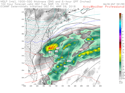
Tuesday Morning: The Final Forecast
*Significant late season snowstorm moves into the region later today through Wednesday*
Good morning. Our winter storm is currently organizing itself and will move into the region starting later today. The main event will not be until tomorrow however. Some snow and mixed precipitation will break out in areas to the south today, but I do not expect much in terms of impacts for most areas. The main area of concern is from around daybreak tomorrow through the evening.
The good news is the bulk of this storm happens during the daylight hours tomorrow. That doesn't mean there will not be imparts but the March sun will help keep the roads more resilient for the metro areas. This makes the snowfall forecast tricky as the grassy areas will do much better. Regardless, you need to expect impacts tomorrow from this as it will snow hard at times. Below is my updated impact map...

Now there are forecasts out there that are much more aggressive with amounts of 8 to 14 inches projected. I am being cautious here due to the late season nature of this storm. From experience, I tend to go more conservative this time of year. Regardless, I do still expect localized amounts over a foot with this storm.
Now to the projections. My model of choice is the regional Canadian for this storm as it has been the most consistent so far.

In the image above you see the evolution of this storm starting form this afternoon and ending tomorrow evening. Notice how the initial wave of precipitation is mostly rain/mixed today. Then by tomorrow morning a new coastal low takes over and pulls in the cold air causing heavy snow to breakout. This snow will last all day and cause the accumulations to pile up. As I mentioned, there will be impacts.
So the bottom line is a major late season storm is moving in. Tomorrow will not be ideal for travel as we get to the late morning hours.
Next update 7pm tonight.
Monday, March 19, 2018
7pm Update: Tricky Forecast, This is My Best Estimate Right now
Given how late in the season we are, snow forecasts are very difficult to make this time of year. Regardless, this storm is right on our doorstep and a forecast has to be made. The video below gives what I think happens tomorrow night thorough Wednesday. I will update this to a final forecast tomorrow morning. Quite honestly this can be boom or bust and I took the middle ground.


Monday Update: Significant Snowstorm Possible Tuesday-Wednesday
Good morning. All eyes will be on Tuesday into Wednesday of this week and we are eyeing up another potential significant snowstorm for the region. This one is a big tricky as I do expect further shifts in the projected storm track. Regardless, I produced an initial impact map which is my best estimate of where I think the biggest impacts can occur. I am going on the more conservative side for now (given uncertainty) and amounts can be higher than what you see below. This will be updated to a final forecast tomorrow morning. I will also have an update out around 7pm tonight.

Summary:


Summary:
- Initial wave of light to moderate snow moves into southern regions tomorrow afternoon
- Expect some minor impact in areas to the south
- The main wave of snowfall moves in later on Tuesday night through Wednesday
- Travel impacts can be expected, especially in the purple zone
- There is the potential for over 6" of snow to fall in the main impact zone but there is still a high degree of uncertainty of how far NW or SE this zone sets up
- Some models have it much more south compared to my map
- My map is based on how I think this trends over the next 24 hours and adjustments will be made if necessary
So lets take a look at how this evolves...
The first wave of precipitation moves into the region tomorrow afternoon...

Areas to the south will be the initial focus as snow will breakout in southern PA and mixed precipitation in SNJ and northern Delaware.
The main event then moves in later Tuesday night through Wednesday as a coastal low develops...
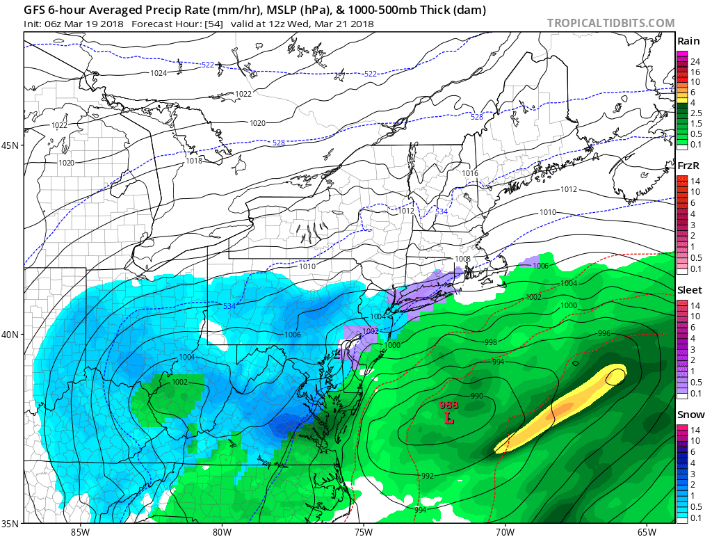

'
The two images above are from Wednesday morning into the early afternoon. Notice how the storm develops and stalls off the coast. This can be quite significant snowfall wise if this low comes close enough to the coast.
There still are differences however in the positioning of the heaviest snow. The NAM model for example is more southeast with the heaviest snow...

My forecast is more NW than this but I want to show that this could happen if I am wrong which would mean a shift SE in my heavy snowfall band.
By Wednesday evening this storm is still off the coast throwing snow back into the area...

The culprit for this storm development is a closed off pattern at 18000ft in the atmosphere....
You can see these two waves of energy phase and cause this storm to blow up along the east coast...


Depending on the final positioning of this process will determine where the significant snowfall sets up.
Stay tuned for the 7pm update!
Sunday, March 18, 2018
Middle of Next Week
All eyes on potential storm system Tuesday and or Wednesday. Detailed post coming tonight or tomorrow morning.
Thursday, March 15, 2018
Thursday Update: Winters Last Hurrah Next Week?
There is some action that could be looming for middle of next week. We have an upper level weather pattern that does support storm development (as we have had this whole incredible March). I will be going into more details over the next few days as I get back from my ski trip Saturday.
PS. Areas of Vt are getting record snow from a lingering upper level low that was part of the storm system this week. Jay peak has already reported over 72"!
PS. Areas of Vt are getting record snow from a lingering upper level low that was part of the storm system this week. Jay peak has already reported over 72"!
Monday, March 12, 2018
Monday Update: Major Snowstorm Targets Eastern New England
Out in the mountains of Utah, but had time to cut a video regarding the major snowstorm that will impact Eastern New England tonight through tomorrow. There will also be some nuisance effects for areas like northern New Jersey and surrounding areas tomorrow morning. The target zone however remains eastern CT,RI,central to eastern Mass,NH and Maine. Expect a few inches of snow possible for the outside areas.
All the details in my short video below..
Sunday, March 11, 2018
Major Snowstorm Hits New England Monday into Tuesday
Good morning. I have been out in Utah so posting is limited, but we have a major snowstorm that will target eastern New England Monday night into Tuesday. To the south, there will be some impacts but not as major as New England.
Lets dive into it.
Low pressure starts to develop off the coast on Monday night...
 This low pressure then starts to rapidly deepen by early Tuesday morning...

This is where snow will really start to pile up quick in areas like RI,eastern Ct, central to eastern Mass, NH and Maine. For areas in the eastern Mid Atlantic a few inches can pile up Monday night. So do not be surprised come Tuesday morning.
By early afternoon Tuesday the storm is still pounding the region. Expect winds to be whipping big time up there.

This looks to be a blizzard for many areas up there. Snow accumulations should be 12+ in the epicenter...
 I personally think we will see 20+ inch amounts in eastern Mass and Maine. There will be blizzard conditions at times.
For areas like in NJ do not expect major impacts from this but a nuisance Tuesday morning. Again, the target is eastern New England.
Stay tuned, more updates to come when I have time to post. Time to hit the slopes!
Lets dive into it.
Low pressure starts to develop off the coast on Monday night...


This is where snow will really start to pile up quick in areas like RI,eastern Ct, central to eastern Mass, NH and Maine. For areas in the eastern Mid Atlantic a few inches can pile up Monday night. So do not be surprised come Tuesday morning.
By early afternoon Tuesday the storm is still pounding the region. Expect winds to be whipping big time up there.

This looks to be a blizzard for many areas up there. Snow accumulations should be 12+ in the epicenter...

For areas like in NJ do not expect major impacts from this but a nuisance Tuesday morning. Again, the target is eastern New England.
Stay tuned, more updates to come when I have time to post. Time to hit the slopes!
Saturday, March 10, 2018
Update 9pm Tnt
In Utah. Still a shot we see a storm Monday. Models are close enough to consider impacts.
Stay tuned.
Friday, March 9, 2018
Friday Update: Rumors of Another Storm Monday?
Good morning. Very brief post as I have to head to work then am flying out to Utah to go skiing.
I will have more details tomorrow morning on all of this. Granted my updates will be on Mountain time so a little later than usual.
Models have been hinting at a coastal storm for Sunday night into Monday but there is a high spread.
The GFS is the closest impacting model for the region..
 The European on the other hand has been persistent on keeping this way south...
I will have more details tomorrow morning on all of this. Granted my updates will be on Mountain time so a little later than usual.
Models have been hinting at a coastal storm for Sunday night into Monday but there is a high spread.
The GFS is the closest impacting model for the region..


At this time I think the Euro is too extreme with this solution. But I am not ready to buy the GFS yet either.
Bottom Line: There is the chance at more snow on Monday but this is far from a lock. Given I will be out of town that increases the likelihood of it occurring.
Stay tuned for more detailed updates on this.
Thursday, March 8, 2018
The Aftermath
What a storm it was. I recorded over 20" in Morristown and areas close to me got 24+.
 I am actually snowed in, power lines and unplowed roads in my neighborhood ate blocking all access out...
 The snow band that produced 3 to 4 inches per hour will go down in history...
 I am calling this the Great Snow of 2018.

Stay tuned, we may have one more on tap next week!


Stay tuned, we may have one more on tap next week!
Wednesday, March 7, 2018
LIVE UPDATES
The 8pm Final Update: 20" of snow in Morristown NJ. I am completly snowed in. This storm will go down in history for the amount of snow it dropped in a relative short peroid of time. It snowed 2-4 inches per hour all afternoon in many spots. Its rare to see this much heavy wet snow. The roads are a mess. What a day it was! Thanks for following...
4:30 Update: Buried Under 15" and Still Pouring Snow
Snow will continue for the next few hours before tapering off in NNJ. For NYC into New England snow will end later tonight into early tomorrow morning (New England).
3:00 Update: The Height of The Storm, Snow piling up fast! 10" and counting...
1230 Update:
From Randolph NJ at 1000ft. 4 inches and coming down hard. This will not be a bust. Next update mid afternoon.
4:30 Update: Buried Under 15" and Still Pouring Snow
3:00 Update: The Height of The Storm, Snow piling up fast! 10" and counting...
1230 Update:
From Randolph NJ at 1000ft. 4 inches and coming down hard. This will not be a bust. Next update mid afternoon.
The Morning Update: Storm Underway, Some Changes to Discuss
Good morning. Our snowstorm is now underway with light accumulations reported in NJ and a moderate snow...

There have been some developments with where the heaviest snow will fall with this storm. I discuss them below.
Our low is currently positioned off the VA coast. This will work its way up and deepen rapidly...

Snow will pick up rapidly in intensity as we reach mid morning, 9am below...

By the time we get to 12pm, conditions are deteriorating rapidly...

Expect snowfall rates of 1-3 inches an hour from 12pm to 5pm. The image below shows the snowfall per hour by this afternoon! This will be an all out snowstorm at this time...

Below you can see the intense vertical motion in the atmosphere to support this..
 So now to the changes...
The storm has shifted east overnight. This means areas in CNJ, NYC, Long Island into Boston now could see more snow than originally thought. New York City is now in the significant impact zone. You can see the shift in snow totals below...

This is a pretty major shift this close to the storm and the observations support it . I am monitoring if anything else evolves out of this. Now subtract a few inches on this image if you live near the coast but it demonstrates the point I am making. Areas out west in NY State and PA will now get ripped off because of this.
Could this completely be a bust? I really do not think so at all, but I am very surprised at this shift so close to the storm.
Stay tuned for live coverage later this morning.

There have been some developments with where the heaviest snow will fall with this storm. I discuss them below.
Our low is currently positioned off the VA coast. This will work its way up and deepen rapidly...

Snow will pick up rapidly in intensity as we reach mid morning, 9am below...

By the time we get to 12pm, conditions are deteriorating rapidly...

Expect snowfall rates of 1-3 inches an hour from 12pm to 5pm. The image below shows the snowfall per hour by this afternoon! This will be an all out snowstorm at this time...

Below you can see the intense vertical motion in the atmosphere to support this..

The storm has shifted east overnight. This means areas in CNJ, NYC, Long Island into Boston now could see more snow than originally thought. New York City is now in the significant impact zone. You can see the shift in snow totals below...

Could this completely be a bust? I really do not think so at all, but I am very surprised at this shift so close to the storm.
Stay tuned for live coverage later this morning.
Subscribe to:
Posts (Atom)