This hurricane will continue to intensity over the next week or so. The national hurricane center has put up its initial maps...
So where does it go from there? We have many solutions on the table right now but the one thing that is constant is that wherever this storm goes in the long range, it will stay a powerful storm.
Here is the latest long range model spread taken from the Canadian model ensemble. I show this because i do not have access to the European Ensemble right now and the Canadian is a good middle ground between the GFS and Euro...
Notice how wide this spread it which is normal due to the fact we are over 7 days away. The concerning thing with this hurricane is that many model solutions have the US mainland in the potential impact zones.
So what are the main scenarios?
1. Irma continues its westward course and moves into the Gulf in the long range
2. Irma makes a turn NW after moving through Hispaniola and impacts the east coast
3. Irma curves out to see off the east coast
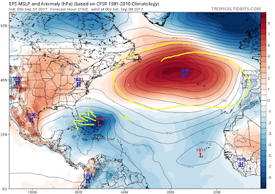
At this time is almost a guess what occurs but history would suggest this storm will follow the fate of scenario number 3. The key comes down to the pressure placement pattern in the Atlantic which steers the storm...
First image is the European ensemble which has a wider more extensive area of high pressure out in the Atlantic. This helps steer the storm more west northwest if correct...
The GFS ensemble has the western edge of the high pressure system less extensive. This lets the storm move more north northeast...
The models have been flipping all over the place on how this actual high pressure center evolves over the Atlantic to steer this storm. In addition, they also are varying on how they handing a trough in the jet stream on the east coast...
The European ensemble has a smaller trough trapped to the south which isn't as influential in kicking this storm more east...
The GFS has a broader sharper trough which allows the storm to make the turn to the north northeast...
More to come on this, stay tuned.


No comments:
Post a Comment