- light to moderate snow moves in tomorrow morning
- Few inches with locally more at higher elevations
- Roads should make out ok
- Potential big storm for early next week
- Details still unclear as this can miss out to sea
- A direct hit would have big impacts
- Chance of impact 50%
- Video tonight 8pm
Good morning. We got snow in the forecast for tomorrow morning and as usual I have made a snowfall map seen below..

Snow arrives just before daybreak and should be over before the afternoon. This shouldn't be a major issue, the higher end of the totals seen above are going to be at elevations above 700ft. Otherwise, I expect most of the accumulation to stay on the grass with some moderate road impacts in spots. This is especially true for any areas south of I-78. I do not expect many impacts there.
Moving on, we have a potential big storm to track for early next week. As usual the details are still very uncertain and models are doing their normal wobble with this system. I am holding myself back from making any bold prediction until at least tomorrow due to the complexity of the situation. However, I think I am starting to iron out where the "miss" will be if this storm doesn't impact our area.
Lets take a look..
Many models currently show a quite significant hit for the region Tuesday...


If we take a look at the model ensembles (normal model's inputs adjusted and rerun multiple times) we see that we have quite the spread of solutions of where the center of the storm can be...
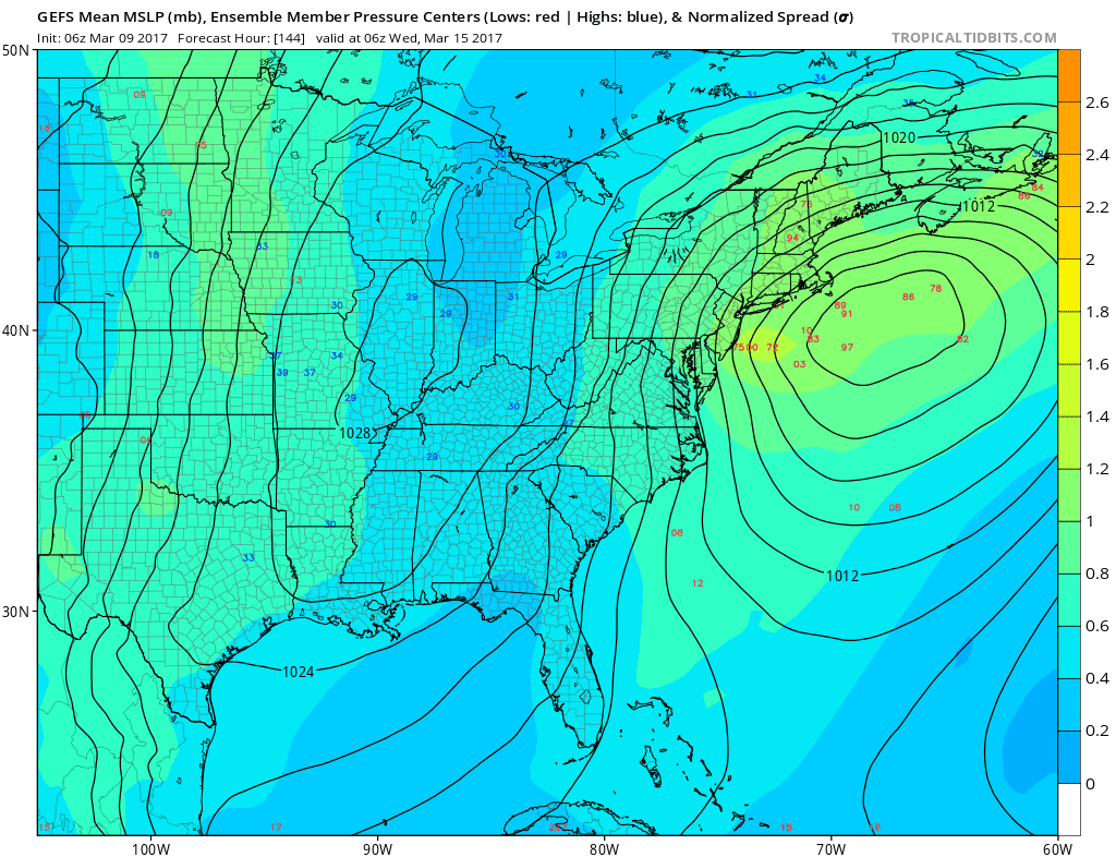
Some members have an absolute bomb off the coast, while others are out to sea. To help with this, we also can look at historical analogs and compare what those results rendered...

It is not that easy however, the key lies at 18000ft in the atmosphere and how interactions occur...

The biggest key, as described yesterday is the strength and positioning of the ridge out west (marked by the line). If this is sharp and positioned say over Montana, it supports low pressure development along the coast. Also, we need to look at the different pieces of energy coming together marked by the X's. The top two have been consistently trying to merge but that pesky southern piece has been dancing around. This can result in development further offshore if it shoots out too far ahead, especially with a weaker ridge.
I will have a video later tonight around 8 to discuss this is more understandable terms. At this point I give the chance of a storm at 50% and would target areas from Harrisburg to NYC to Boston to Portland. The miss here will def be out to sea. Lets see how the trends come in over next 36 hrs. If by tomorrow afternoon this is more east I think we can bury it.
Even for the possible last chance at a good snow for the year, the big snow misses the snow-hole areas again: from the NWS Binghamton- NY Both the GFS/ECMWF keep the low pressure system well east of the region so a big snowstorm at this point looks unlikely, although still plenty of time for adjustments.
ReplyDeleteLingering snow showers Tuesday night behind coastal then
primarily dry both Wednesday and Thursday