WINTER FORECAST 2017 WILL BE RELEASED ON WED OCT 19TH
Good morning everyone. Well, the real time track of Matthew is now in and it is good news. Yes the forecasts where all wrong including my own about the major impacts this storm would have but in this case that is wonderful news. Shows you how when a forecast literally comes down to 40 miles computers are in many cases useless! The issue is if a forecaster then downplays the storm and they are wrong, the end result is ten times worse than if they err on the side of caution. There is no better example than Hurricane Matthew which has winds of over 120 mph literally miles off the Florida coast.
So here is the current storm..
You can see the eye wall circled in red. This is where the most intense destructive winds are in a hurricane. This literally is going to say just 40 miles offshore. The difference of this is huge! 40 more miles west and we have a big natural disaster. Models sometimes cannot handle details that small just like in the winter when we are trying to nail down a rain snow line!
In any event, 100% of forecasts were wrong. The problem is it would have been foolish for anyone to downplay this and be on the wrong side of the bet. Unlike the winter where it is rain vs snow, this is life vs death.
The National Hurricane Center has adjusted their track..
Winds will still be gusting up to hurricane force in places. The rainfall will also be an issue. Here is projected rain through this weekend..
Yellow colors are up to 10 inches. That will cause impacts in verified.
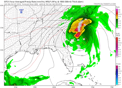
You can see how this storm just bends up southern coast..
No impacts north of the Carolina's.
Thanks all for now.


No comments:
Post a Comment