Saturday, January 31, 2015
Updated Forecast for Sunday Night into Monday

Thanks for being patient guys I had to work a little longer than expected but above are my updated thoughts on the upcoming storm system. As we have been discussing the models have been trending north and that is reflected in this map. However, I do think certain models like the UKMET and GFS are a little too far north so I slightly adjusted them south.
A few things to note:
- Snow looks to break out in most areas late Sunday night
- Snow changes to rain in the green zone and freezing rain in the pink zone
- I expect the low level cold air to put up a fight which will cause the rain to freeze
- In the red zone, snow accumulates early Monday morning but then sleet should mix in by day break .
- This will cut down accumulations in that region
- There will be a paper thin gradient between 4 or 5 inches and 10 inches in this area depending on the intensity of the precipitation
- The closer you are to I-80 the better for more accumulations
- In times of heavy precipitation you can see a changeover to snow in the northern part of this zone which is why totals go up to 10 inches.
- The bulls eye is southern New England with this storm
- Some sleet may mix in to the south especially over NJ at times but overall I think its a significant snowfall
- Storm should be over by the early afternoon Monday
As always I will have a video update tonight around 6.
Updated Forecast and Snow Map Out at 1:30pm
Need to actually head into work this morning for a client meeting but I will have the updated forecast out early this afternoon when I have time to draw the map. After looking at the latest model guidance it is very likely that factors behind the northern trend I discussed in my video last night will be reflected in my map. What will that mean..
Remember there is a lot of cold air in place due to that arctic high. We can not underestimate this. Even though some areas do not get heavy snow, ice can still be an issue if the cold air holds at the surface.
- Central NJ and South Including Philadelphia
- You are likely sitting this one out
- Any snow that starts will change to ice then rain
- Little or no accumulation
- Northern NJ
- The battle zone of this storm I think is between the I-78 and I-80 corridor meaning that there can be mixing issues that cut down accumulations.
- 15 Miles can be the difference between 4" and 10" in this spot
- Do not discount the snow cover as it can help enhance the baroclinic zone which the low will want to travel along
- North of I-80 into New England looks to be in the best spot for significant snow accumulations around 8-14"
Remember there is a lot of cold air in place due to that arctic high. We can not underestimate this. Even though some areas do not get heavy snow, ice can still be an issue if the cold air holds at the surface.
Stay tuned for the updated forecast!
Friday, January 30, 2015
Friday Night Video Update: Breaking Down Upcoming Storm and Tracking That Rain/Snow Line
The video below is a play by play of how this storm Sunday night is going to evolve and what factors are going to determine the rain/snow line. This will be a significant storm for many areas especially to the north. For central Jersey the jury is still out and I will have a better idea by tomorrow morning if you guys have big mixing problems.
The final forecast is out tomorrow as I evaluate the final factors that will determine the fate of this storm. For now the word preliminary is still in play but I like what I have.
The final forecast is out tomorrow as I evaluate the final factors that will determine the fate of this storm. For now the word preliminary is still in play but I like what I have.
Friday Morning: Preliminary Forecast on Late Weekend Snowstorm
Good morning everyone. I have looked at enough data to put out my preliminary forecast for Sunday into Monday. At this time it looks very probable that a moderate to significant winter storm is on the way for the region. Unlike the last storm, this should be a little easier to hone in on due to the fact its set up is not as complex. Regardless, this is still a preliminary forecast and will be updated this weekend to the final forecast.
This storm will not be nearly as deep (pressure level) at the surface as the last storm, however it is going to carry a lot of moisture with it. An area of low pressure will develop in the Ohio/Tennessee valley on Sunday morning as slide just south of the area as we head into Monday morning. The worst part of this storm should be between the hours of 1-7am. However, snow should break out by Sunday late afternoon for many areas. This will be a cold storm to the north meaning the ratio of liquid to snow will be higher. I expect ratios up to 15:1 for Northern NJ into southern New England. This will enhance snow totals. To the south ratios will be a little lower.
For the Balt/Wash area, I expect snow to break out Sunday afternoon but then turn to a mixed bag of precipitation as we approach later Sunday night. This will cut down accumulations. Regardless, you can still expect a moderate accumulation especially just to the northwest of those cities.
Here is my initial Impact map:

This is just an initial estimate and like I mentioned will be tweaked as we approach the event. I am basing this prediction on the decent consistency I see with the GFS,European and their ensemble models. The Canadian model is more south of that guidance but based on it's ensemble seems to be too far south.
Here is the model spread:
GFS:

Canadian:
 Canadian ensembles suggest this is too far south based on their spread to the north..

European is similar to the GFS which I do not have an image of.
Biggest risks to this forecast:
The biggest risk I see to this forecast is a sudden trend north with this system. I think the risk to a northern movement is greater than a southern movement at this time. If that was to occur the whole snow map would be adjusted north and the mixed precipitation could extend all the way into central NJ. That is not my forecast at this time.
I will have a video update tonight at 7pm. Stay tuned!
This storm will not be nearly as deep (pressure level) at the surface as the last storm, however it is going to carry a lot of moisture with it. An area of low pressure will develop in the Ohio/Tennessee valley on Sunday morning as slide just south of the area as we head into Monday morning. The worst part of this storm should be between the hours of 1-7am. However, snow should break out by Sunday late afternoon for many areas. This will be a cold storm to the north meaning the ratio of liquid to snow will be higher. I expect ratios up to 15:1 for Northern NJ into southern New England. This will enhance snow totals. To the south ratios will be a little lower.
For the Balt/Wash area, I expect snow to break out Sunday afternoon but then turn to a mixed bag of precipitation as we approach later Sunday night. This will cut down accumulations. Regardless, you can still expect a moderate accumulation especially just to the northwest of those cities.
Here is my initial Impact map:
This is just an initial estimate and like I mentioned will be tweaked as we approach the event. I am basing this prediction on the decent consistency I see with the GFS,European and their ensemble models. The Canadian model is more south of that guidance but based on it's ensemble seems to be too far south.
Here is the model spread:
GFS:
Canadian:
European is similar to the GFS which I do not have an image of.
Biggest risks to this forecast:
The biggest risk I see to this forecast is a sudden trend north with this system. I think the risk to a northern movement is greater than a southern movement at this time. If that was to occur the whole snow map would be adjusted north and the mixed precipitation could extend all the way into central NJ. That is not my forecast at this time.
I will have a video update tonight at 7pm. Stay tuned!
Thursday, January 29, 2015
Thursday Morning: A Closer Look at Potential Monday Snow Event
I just broke down the models for the Sunday night into Monday situation. As we have been reviewing there is a chance a area of low pressure impacts parts of the region in that time frame. At this time it appears the GFS and European operational models are a little too far south with their snow shield.
Here is the GFS..
 The Canadian is likely too strong..


Here is the GFS..
I like a blend between the two due to the ensemble's on the GFS and Euro having a spread to the north. Here is the GFS ensemble spread. This basically shows you how the operational model might be wrong. Notice the spread to the north indicated by the shaded colors..
I think the press of arctic air is an issue here so the storm will only be able to make it so far north. The Canadian is more aggressive because it really wants more interaction with the southern branch of the jet stream.
Regardless a big key to this is the clipper system coming through tonight. This can drop an 1-3 inches in places to the north..
We then need to see how this departing clipper sets up in southeastern Canada, its impact on the jet stream and how high pressure sets up ahead of the next storm. If the models are not currently handling that accurately that can have drastic implications on the forecast.
At this time this is my threat map for the chance at moderate snow for this storm..
I should be able to really hone in on this in the next 24-36 hours as we see this clipper move through. Lets see how this evolves.
I will try to have an update later tonight.
Wednesday, January 28, 2015
Monday Morning: Taking a Look at Sunday into Monday
Quick post this morning on the late weekend into early next week situation. As I mentioned last night in my video the upper air pattern looks like it will want to form a storm for this period. However, there are a lot of questions that remain before any snow lovers out there get excited.
In particular:

Few things to note when looking at the image above. All models have roughly a similar look as this. That means they all are showing a storm Sunday night into Monday. Some areas get a lot of snow with the current projections of this storm if the maps are taken verbatim (no not 3 feet). However, we do not forecast by just looking at the surface output of each model run. Instead we need to focus on the map above and determine if the proper chess pieces are in place for the ideal storm track. So lets do a quick summary of how these look and I will have more detail tonight..

In particular:
Few things to note when looking at the image above. All models have roughly a similar look as this. That means they all are showing a storm Sunday night into Monday. Some areas get a lot of snow with the current projections of this storm if the maps are taken verbatim (no not 3 feet). However, we do not forecast by just looking at the surface output of each model run. Instead we need to focus on the map above and determine if the proper chess pieces are in place for the ideal storm track. So lets do a quick summary of how these look and I will have more detail tonight..
- You see the high pressure over Greenland on the image above noted by the red colors. This is called a negative NAO and is a good precursor to storms. However notice the high pressure system is on the east side of Greenland.
- This means there is a chance that a storm that forms could cut to the west of the major cities which would mean a no snow threat.
- Its not the end all be all however as that negative NAO does enhance the next factor which is
- The 50/50 Low
- I talk about this a lot because it is important. This low pressure system in southeastern Canada is key because it locks in high pressure to its west. High pressure supply's cold air to storms
- This develops as a result of our late week clipper moving out of the area
- Ridge out west
- Always a key to a storm as the more amplified it is on the west the stronger the trough is downstream in the east
- If the ridge axis is too west however it can increase the chances of the trough being too far west which could cause the next issue
- Do the northern and southern jet streams phase too early due to ridge being too far west.
- this is a possibility and would result in major cities seeing no snow and instead the snow being confined to interior areas.
- Since we have that east based -NAO it doesn't help in this circumstance
Bottom line I am gaining confidence a storm system will effect the region on Sunday night into Monday. More importantly, I need to see how these factors evolve and change over the next few days before getting an idea of who is in the cross hairs for a shot at snow.
Just because the GFS model is currently showing this for a snow printout does not mean I will say ok guys here comes more snow. Let The Weather Channel do that.
If anything this snow printout is not accurate right now because there would be some ice in areas to the southeast on this image. The European model is showing even more snow. Let's not jump the gun yet here. I am all for making bold predictions, but it still is too early.
Let's wait another 24-36 hours.
More tonight.
Tuesday, January 27, 2015
Tuesday Night Pattern Update: Moving on from the Great Bust of 2015, Action Could be Looming Ahead
Video below discusses pattern evolution over the next 10 days and the prospects for future storms. Winter is just getting started and I think we got at least a good 3 week period ahead of us heading into February.
Enjoy..
Tuesday Morning: So What Went Wrong?
Good morning everyone. Well it was sure a big one! A big bust that is. I apologize for the bad call on this one, believe me, I will not forget it for a while. So before we discuss why this storm busted lets look at what is currently going on.

We have intense snow falling right now with blizzard conditions in eastern CT, Mass and Maine. Snowfall rates of 2-3 inches per hour! You will see some imporessive snow amounts come out of those areas. Down to the southwest the intensity is only reduced. Long Island looks like they did pretty well with this storm. You will see accumulations of over over a foot there. NYC had a decent accumulation so far, but no where near what was expected. To the west of NYC some snow did accumulate overnight and you can see the snow is still underway but it is not intense.
Our storm right now is sitting just to the southeast of Cape Cod at 976 millibars and completely bombing out.
 So lets get into what went wrong, because you can see the storm is very impressive on the satellite.
Two parts as to why my forecast busted along with other so badly this time- The meteorological reason and the mental reason.
The meteorological reason:
The low simply formed too far east compared to what the European model was saying.
Actual low position at 1am..


We have intense snow falling right now with blizzard conditions in eastern CT, Mass and Maine. Snowfall rates of 2-3 inches per hour! You will see some imporessive snow amounts come out of those areas. Down to the southwest the intensity is only reduced. Long Island looks like they did pretty well with this storm. You will see accumulations of over over a foot there. NYC had a decent accumulation so far, but no where near what was expected. To the west of NYC some snow did accumulate overnight and you can see the snow is still underway but it is not intense.
Our storm right now is sitting just to the southeast of Cape Cod at 976 millibars and completely bombing out.
Two parts as to why my forecast busted along with other so badly this time- The meteorological reason and the mental reason.
The meteorological reason:
The low simply formed too far east compared to what the European model was saying.
Actual low position at 1am..
Europeans projection at the same time..
I know this doesn't look like much, but it had drastic implications on the forecast. This was a very complex storm that depended on the transfer of energy to the coast. That transfer of energy was extremely hard to model and pin point. As good as the European model is, this was a major failure.
But where there warning signs? Yes!
The GFS, Canadian, North American and British (UKMET) model threw many warning signs as their forecasts began to shift east Sunday. So why where they ignored? I think the reason to that is part two of why this forecast was a failure, physcology.
Everyone has learned to praise the European model over the last few years. After all it was for good reason. The other models, in particular the GFS, always seemed to be wrong and push storms too far east. Eventually, they always came back in line with what the European was saying.So when the European model showed an epic blizzard on its run Saturday night, Sunday and Sunday night the whole meteorological and amateur weather community jumped on board. All of a sudden a herd mentality developed and it seemed like no matter where you went the totals kept getting higher and higher from everyone. The National Weather Service came out with almost unprecedented snowfall protections and all other outlets followed. Meanwhile those other models lingered and suggested otherwise. There was no turning back now.
Now when I make a forecast I always favor the European. However, how many times have you heard me say " the European looks the best here but you need to blend in the GFS and adjust east a little. I would say take a blend of 65% Euro 35% GFS." Also how many times have you heard me praise the UKMET model as being very accurate. Why did I break form this time and go against what has worked so well in the past? Well, part of it might be what I just listed above but the other part was that I did not want to believe in this extreme case that the European model would be wrong. In other words, I let my snow bias effect the clarity of this forecast. I was waiting years for a storm this big to hit the area again. Well, it resulted in me getting burned. Hopefully as we move throughout the rest of the winter I learn from this failure and the accuracy of my forecasts are a beneficiary of that.
We have a great stretch of winter ahead of us over the next several weeks. The snow that has fallen will not melt quickly and temps will get very cold. There is the chance at light snow later in the week and the pattern is ripe for storm development. If we take a step back for a second, we just had two moderate snow events in a few days so no one can argue that winter is not here.
I will get back to work and try to keep everyone ahead of the weather as it unfolds. Let's hope next time I am faced with more success and I am confident I will be.
Thanks for all the new followers it makes this passion of mine worth it.
Monday, January 26, 2015
Final Verdict. It Will Snow Tonight, But Western Counties Bust
My forecast snow amounts are clearly too high for all areas west in NJ and maybe NYC. Up north and east it might do ok. It will snow tonight in NJ and we might actually get a surprise and get some decent accumulation but no where near the amounts I have. This storm is very large so when it stalls out we will get some of its moisture. I'm watching all forecasters wiggle out of their predictions by slowly tweaking the amounts down. I am not going to do that and just say it how it is. The comment section is open for anyone who wants to blow off steam and use a few choice words about my forecast.
Many models hinted at this but the European model and its ensembles did not and stayed remarkably consistent. This time they look to be wrong. Of course anything is possible but I am pulling the plug on significant accumulations on all areas basically to the west of I-287.
I will be watching this evolve and there will be more updates to come.
Here is what is going on...
Latest model guidance is conflicting. However there are signs of errors in it. Regardless, in the interest of providing you guys with the most accurate information I need to wait for observations. My goal is to be up front with everyone and let you know if I think this will be a busted forecast for some areas. That is a risk but it is impossible to know for sure until I evaluate these snow bands moving in off the ocean now..

Bottom line these bands will spread into NJ or just skim the coast and head northeastward. The latest model guidance is not buying the fact they will move all the way into NJ. However the storm is still following what the afternoon European model projected. The European had these bands coming on shore. The whole fate of this storm lies in the next two hours.
If this ends up being a major bust, I will be the first to admit it and take it on the chin. There is no room for pretending this was part of my forecast on this blog.
Stay tuned, I will make the final call as soon as I can. Thanks for being patient.
4pm Update: A Blizzard Has Been Born
More footage to come as the evening and night go on. I share my excitement behind the meteorology in this video but its important to note that this will be a dangerous storm so be careful!
As an accessory to the video check out these projected wind gusts in knots very early tomorrow morning. I will try to get into the thick of that.

As an accessory to the video check out these projected wind gusts in knots very early tomorrow morning. I will try to get into the thick of that.
Blizzard of 2015 Morning Update
Good morning lets dive right now to it. I made a few small tweaks to the snow map after last nights model runs..
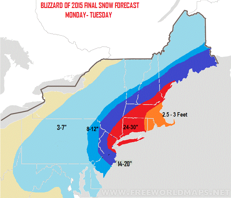
Notice I have 14-20 where I had 18-24. Not a huge change but I thought it was necessary based on the latest data that did shift things a little east. I also want to note that on the western fringes of the red zone should be a max of around 24" I do not expect 30 there. Otherwise, forecast looks to be on track.
The storm is not developed yet as seen on radar.
 The snow that is falling now is from the clipper that is sitting to our west. This will redevelop off the coast tonight and that is when the real fun begins. Expect light snow all day with some accumulations but nothing major. I will say again this is just an appetizer and is not the main storm today.
Look how cold the air mass is right now. All due to that arctic high pressure system that is sitting to the north. This will keep the snow ratios high meaning an inch of liquid could produce 15 or 20 inches of snow instead of the standard 10.

Tonight into Tuesday is when the storm starts cranking as that low pressure system redevelops and explodes off the coast. A simulated radar is seen below. This is when everyone needs to be on alert.

Notice the sharp cut off in snow to the west. We need to keep an eye on this and I fully expect it. That means someone towards the west can get ripped off. It is all going to depend on where the heavy snow bands set up. I will be analyzing that in real time tonight and tomorrow.
Below are the sustained wind speeds in knots tonight and tomorrow morning. You can see why there are blizzard warnings near the coast.

Need to get to work now, but expect a big update coming sometime closer to the evening hours. My goal is to keep everyone ahead of the storm. In the meantime you can find a few comments on twitter.
Stay tuned for live coverage tonight! As crazy as you all know I am by now you bet I will have footage.
Notice I have 14-20 where I had 18-24. Not a huge change but I thought it was necessary based on the latest data that did shift things a little east. I also want to note that on the western fringes of the red zone should be a max of around 24" I do not expect 30 there. Otherwise, forecast looks to be on track.
The storm is not developed yet as seen on radar.
Look how cold the air mass is right now. All due to that arctic high pressure system that is sitting to the north. This will keep the snow ratios high meaning an inch of liquid could produce 15 or 20 inches of snow instead of the standard 10.
Tonight into Tuesday is when the storm starts cranking as that low pressure system redevelops and explodes off the coast. A simulated radar is seen below. This is when everyone needs to be on alert.
Notice the sharp cut off in snow to the west. We need to keep an eye on this and I fully expect it. That means someone towards the west can get ripped off. It is all going to depend on where the heavy snow bands set up. I will be analyzing that in real time tonight and tomorrow.
Below are the sustained wind speeds in knots tonight and tomorrow morning. You can see why there are blizzard warnings near the coast.
Need to get to work now, but expect a big update coming sometime closer to the evening hours. My goal is to keep everyone ahead of the storm. In the meantime you can find a few comments on twitter.
Stay tuned for live coverage tonight! As crazy as you all know I am by now you bet I will have footage.
Sunday, January 25, 2015
THE BLIZZARD OF 2015 VIDEO BREAKDOWN
This is it guys, a storm of historical proportions is now starting to develop and will clobber the northeast over the next few days with feet of snow. The video below has my new snow map and a play by play of the storm.
A few points:

A few points:
- Snow breaks out tomorrow morning but is generally light
- The heavy snow starts Monday night and lasts into Tuesday afternoon
- This is the brunt of the storm and will feature high winds and snowfall rates up to 4 inches an hour
- Travel will be impossible for some spots
- Storm ends Tuesday evening for most areas and lingers in New England into Wednesday
- When it is all said and done this should be one for the record books
- Is there bust potential?
- very low probability, I touch on this in the video
Rest assured you will get frequent updates as this storm is underway including unmatched raw footage from my backyard. Feel free to follow me on this blog or via twitter as the storm is underway for up to the min updates.
Enjoy the video:
Change of plans getting home earlier video up at 8!
Don't want miss this one guys. I will give you every detail you need to know
MAJOR BLIZZARD TO EFFECT AREAS OF THE NORTHEAST
Again I am still skiing but will have a big video tonight at 1030on this historic storm.
Prepare now, the storm is coming and will last from Monday Afternoon to Tuesday afternoon. Storm will feature heavy rates of snowfall and gusting winds creating blizzard conditions at times. This storm has the chance to be the biggest storm for some areas since Feb 2010.
Here is my updated snow map and I will actually have a better looking one out tomorrow morning. Some local areas can see 3 feet!

More updates later this afternoon when I'm heading home. Stay tuned, there is a slight chance this storm develops more North and the red zone moves into just the Boston area. I will keep you updated..
More later and video at 1030
Prepare now, the storm is coming and will last from Monday Afternoon to Tuesday afternoon. Storm will feature heavy rates of snowfall and gusting winds creating blizzard conditions at times. This storm has the chance to be the biggest storm for some areas since Feb 2010.
Here is my updated snow map and I will actually have a better looking one out tomorrow morning. Some local areas can see 3 feet!
More updates later this afternoon when I'm heading home. Stay tuned, there is a slight chance this storm develops more North and the red zone moves into just the Boston area. I will keep you updated..
More later and video at 1030
Saturday, January 24, 2015
Saturday eve: Is A Major Snowstorm/Blizzard On the way?
Well the answer appears to be yes. Please excuse the format and grammer of this post as I am skiing and have no computer. This is all being done on my cell phone, but I am so excited about this potential a post is very necessary.
So what is the potential here? The potential is for major storm system to develop behind a shot of arctic air tonight. This means it will be very cold so this is a all Snow threat for mostly every area from Delaware to Maine. This is a storm system that has the POTENTIAL to be historic as the region in its bullseye could be taking about feet of snow. I wish I had the capability to make a video because I am very amped up on the setup leading to this storm. We are only 36-48 hours away so a storm is def coming the question just remains who gets the bullseye NYC area or Boston?
So let's dive right into it. The image below shows the cold air in place ahead of the storm due to an arctic high in Canada. This is a KEY ingredient as it supply a boatload of cold air for all regions..

All the blue represents cold air and you can see the high pressure center North of VT.
Our storm developes due to a northern disturbance diving sharply down from Canada. The ridge of high pressure out west is key as the more amplified it is the more the storm will hug the coast. Models have trended favorable on this.
 I drew out in the image above the key factors here. That ridge causes the blue disturbance to dive deep into the east and develop a surface low off the coast. Ahead of the low we have our old storm from today around Nova Scotia and high pressure developing to the north of it over Greenland. This is another key ingredient. The old storm is called a 50/50 low and acts to hold in place the cold high pressure that you saw on the first image. The high pressure over Greenland is a slight negative NAO which usually goes along w a 50/50 low. Why is this important??? Because it not only holds cold air in place but slows storm down off the coast or blocks it! This means it stalls out and deepens. Naturally that gives this the shot to be historic as massive amounts of moisture aided by the warmer than normal Atlantic will be thrown back into the cold air in place. What you are left w is someone getting an epic snowstorm, some getting a decent storm, and some getting ripped off.
The biggest key as to if it's NYC or Boston to Me is how steep ridge gets. We need a very steep ridge like the European shows to get the bullseye into NYC area into NJ. The gfs was shallower w ridge thus was more east and North w storm mainly hitting Boston hard and more moderate snow South.
Why am I going I to this detail? Because you guys need to understand I can't make a final call until tomorrow on who's actually gets clobbered.
Here is gfs model for Monday night into Tuesday.

Can't show precip but check out euro below and the high to the north blocking this storm from leaving
 This is so impressive. As we can have an event that lasts from Monday afternoon to Tuesday afternoon. That is very rare hence why I am calling this potentially historic.
Here is my first map on this situation. The red zone is potentially 2 feet of snow hence the bullseye.
 Bottom line a storm is likely and it can be of long duration and significant. I still need to wait till tomorrow to hone in on this as small changes can cause some areas to bust badly and not get much snow while others get clobbered. For example a small shift North means Boston gets feet of snow on and NJ 6 inches.
I will have a quick update tomorrow morning and add some stuff to my Twitter during the day as data comes in.
When I'm home finally tomorrow night I will have a final forecast map and video around 1030. It's funny I didn't take my computer w me on this trip BC i was superstitious that there would be no storm to post on if I did. Yes I am that nuts.
Stay tuned!
So what is the potential here? The potential is for major storm system to develop behind a shot of arctic air tonight. This means it will be very cold so this is a all Snow threat for mostly every area from Delaware to Maine. This is a storm system that has the POTENTIAL to be historic as the region in its bullseye could be taking about feet of snow. I wish I had the capability to make a video because I am very amped up on the setup leading to this storm. We are only 36-48 hours away so a storm is def coming the question just remains who gets the bullseye NYC area or Boston?
So let's dive right into it. The image below shows the cold air in place ahead of the storm due to an arctic high in Canada. This is a KEY ingredient as it supply a boatload of cold air for all regions..
All the blue represents cold air and you can see the high pressure center North of VT.
Our storm developes due to a northern disturbance diving sharply down from Canada. The ridge of high pressure out west is key as the more amplified it is the more the storm will hug the coast. Models have trended favorable on this.
The biggest key as to if it's NYC or Boston to Me is how steep ridge gets. We need a very steep ridge like the European shows to get the bullseye into NYC area into NJ. The gfs was shallower w ridge thus was more east and North w storm mainly hitting Boston hard and more moderate snow South.
Why am I going I to this detail? Because you guys need to understand I can't make a final call until tomorrow on who's actually gets clobbered.
Here is gfs model for Monday night into Tuesday.
Can't show precip but check out euro below and the high to the north blocking this storm from leaving
Here is my first map on this situation. The red zone is potentially 2 feet of snow hence the bullseye.
I will have a quick update tomorrow morning and add some stuff to my Twitter during the day as data comes in.
When I'm home finally tomorrow night I will have a final forecast map and video around 1030. It's funny I didn't take my computer w me on this trip BC i was superstitious that there would be no storm to post on if I did. Yes I am that nuts.
Stay tuned!
MAJOR BLIZZARD POTENTIAL MONDAY.. STAY TUNED
Post coming sometime this eve you don't want miss this guys.
On the slopes
Limited posting abilities but looks like storm is doing well down there with snow. Very quick hitter so ending in some areas soon. We will see how my map ended up doing later when it's all said and done. Euro last night got interesting w the system for Monday. I will take a closer look at that this eve and have a quick updated post. Here was it's run last night..

Hmm could this tend even more? We will see.
Hmm could this tend even more? We will see.
Friday, January 23, 2015
Friday Morning: Final Storm Map Out, A Look at Early Next Week
Just going to post the map today, I beat this dead horse enough with this storm. Here is what to expect:
- Snow breaks out in many southern zones Friday night.
- Snow changes to sleet and freezing rain in green zone early Saturday morning.
- There might be some minor accumulation
- In the red zone snow lasts longer into day break but then changes to sleet and some rain.
- In the light blue zone there should be some mixing especially near NJ and CT but not as much as the red zone so accumulations are higher
- The money spot is the dark blue zone where it should stay mostly snow and have enough moisture to bring accumulations to over 6 inches.
- This storm is mostly cleared out by Saturday night expect for the zones furthest to the northeast.
We now focus on a clipper system that has the chance to redevelop on Monday into Tuesday..

Could this be a moderate to heavy snow event? Maybe, but way to early to say- a non event is just as likely as again it all depends on a few features.

The more that energy circled in red digs down into the southeast is key. The ridge out west needs to air in this. The steeper the ridge the more the disturbance digs. Not a whole lot of blocking ahead of the clipper but we have a lot of cold air.
Welcome to the world of high pressure..

Nice 1024 high over Canada funneling all that cold air in. Not all models show this and it can very well stay progressive and go out to sea but we need to watch it over the weekend.
I will be skiing in Jay Peak, VT this weekend so may be limited in posting and there will be no live coverage of the storm this time. However, rest assured if this clipper trends nicely you will hear from me.
Thursday, January 22, 2015
Thursday Night Video Update: Update on Storm Impacts
My forecast still stands. In the video I go through what I look at to determine the rain snow line and verbally discuss what to expect with this storm. I also start to briefly talk about early next week and how we have to be on the lookout for a little mischief. My final map comes out tomorrow morning and I will have more details on early next week.
Thursday Morning Storm Update: Had to Make a Realistic Forecast

There it is guys the final map. As you all can see I made some adjustments. Lets go through a few points here.
1. The storm will develop to be very strong with a low pressure center below 980.

2. Big problem is the sharp cutoff in moisture on the western side of this storm. The brown colors are dry air..

3. I have talked about no high to the north of the storm and now its really going to become a issue based on the latest model guidance which I can not ignore. Look at how much warm air surges into the mid levels of the atmosphere by 1 pm Sat below. This causes snow to change to sleet and plain rain in some areas. The problem is that is when a bulk of the precipitation will fall.

4. Areas where it should stay all snow are limited in how much precipitation or moisture falls out of the sky. This make there a small area where I expect 3-6 inches of snow.

5. What you are left with is a storm that is not going to be as significant as I expected. I think its very important to be honest and not try to slowly shuffle out of a bad initial forecast. I think you guys saw I always expected mixing and mentioned the warm air being an issue due to no high pressure to the north in my videos. However, I did not expect the warm air to dominate areas to the north west as much as its being shown. I also thought the storm would carry more moisture on the western side thus having a longer period of snow.
6. What you are left with is my initial area of 6+ of snow(the blue region on my old map) being reduced to 3-6 and that 3-6 being pushed to the north west. The mixing line was expanded further to the northwest as well. Maybe i'm being too hard on myself but I am not going to pretend that was the forecast from the start I def expected some higher amounts. At least I waited till today to have an accumulation map.
I am a little disappointed I didn't have better foresight to weight some of these factors a little more. However the goal of this blog will always be to take a stance and that means a initial forecast has to be made before the day of a projected storm. Otherwise anyone can go to the National Weather Service web site and watch the forecasts change by the hour. So yes it means I will be wrong at times- hopefully I end up being right more than I am wrong.
Yes of course things can still change since we are still 48hrs away. I will keep everyone updated. Thanks for all the new followers and for checking in. Assuming things don't shift back to a snowier scenario in the next 48 hours hopefully I can do a little better with the initial forecast next time.
We have another shot at snow early next week and I will start to focus on that as the days go on.
Wednesday, January 21, 2015
Wednesday Night Update: The Storm Is A Lock, The Big Question is the Rain/Snow Line
Video below is my latest update to the storm that will effect the region on Saturday. I breaks down a critical component to this storm which is where I think the rain snow line will set up. My first accumulation map comes out tomorrow morning.
Enjoy.
Enjoy.
Wednesday Morning Storm Update: Thoughts Consistent with Last Night
Good morning guys. I do not have much to add this morning. I laid out my initial ideas in my video last night. I plan to have a big update tonight and might attempt to speculate on accumulation amounts. At this time, I do not know how moderate or heavy they will be. I need another run or two of models to study the trends.Last nights model were generally consistent and it will be interesting to see how everything evolves today. Here was my impact map from last night which represents my initial thoughts on this.

I am very confident that this low pressure system becomes very strong, but I am not confident in the precipitation amounts or wind at this time so I am not ready to give accumulation projections. To give you an idea, potential heavy snow would be defined as 6+ inches possible in the most general sense. It does not mean a foot or more at this time so make sure you guys understand this map, it is a very general idea and can change. I hope I am off to a good start with this but time will tell.
In terms of this clipper system today I am not making a map because believe it or not I do have a day job so time in limited. However, here is the GFS projection for snow amounts. Generally expect 2-4 inches in southern zones with up to 5 possible in local areas.

P.S. Yes there still is another shot at a storm early next week, but lets focus on the Saturday situation first.
More tonight around 730, thanks for checking in.
I am very confident that this low pressure system becomes very strong, but I am not confident in the precipitation amounts or wind at this time so I am not ready to give accumulation projections. To give you an idea, potential heavy snow would be defined as 6+ inches possible in the most general sense. It does not mean a foot or more at this time so make sure you guys understand this map, it is a very general idea and can change. I hope I am off to a good start with this but time will tell.
In terms of this clipper system today I am not making a map because believe it or not I do have a day job so time in limited. However, here is the GFS projection for snow amounts. Generally expect 2-4 inches in southern zones with up to 5 possible in local areas.
P.S. Yes there still is another shot at a storm early next week, but lets focus on the Saturday situation first.
More tonight around 730, thanks for checking in.
Tuesday, January 20, 2015
Tuesday Night Video Breakdown: A Big Storm on the Horizon
So is a big storm coming or is it all hype? Video below goes through my initial thoughts on how this potential big storm can develop and how each region of the Northeast will be effected. I have an impact map in the video showing my estimate of the rain snow line. I will hone in on the details as the days go on. This is just a preliminary forecast for now and things can change.
Enjoy..
Note: the mixing line I have in the video might be a little too far to the west in Northern NJ
Enjoy..
Note: the mixing line I have in the video might be a little too far to the west in Northern NJ
n
Tuesday Morning: Major Storm Potential on the Boards for this Weekend
Well, we got a big one on the boards here guys. I will start off by saying I am still not completely sold that this turns up the coast, but I need to acknowledge the potential here. Let's start off by showing the surface map of last nights European for Saturday..
 Yup, look at the pressure level of 974 that's a very powerful storm being projected for Saturday. In fact, if I look at the European ensemble which basically takes this model and adjusts the inputs 52 times running 52 trials, 41 of those 52 trials have a low pressure system that is below 980. As a reminder anything below 990 is considered a powerful storm to me.
If we took this verbatim, it would mean majors snows for south the south NJ and Baltimore Washington area. I may add that almost every model is showing this storm and mostly all of them have this similar track. None of the models are turning this up the coast which means north Jersey, NYC, Boston ect. stay out of heavy snow. I hate to say it, but I think that is a believable outcome. The reason once again comes down to the pattern ahead of the storm and yes once again the -NAO.
Now it is possible to get a major storm without a -NAO, the probability is just lower. Without this pattern in place (high pressure over Greenland) the pattern tends to be more progressive. To get the big hit you need the timing to be perfect between the northern and southern jet streams merging. Thus, that is the case here. We need to depend on a very steep ridge out west helping the chances that the two disturbances combine.
Here is a simple view of this..

Basically what you see above is the jet stream rising to the west shown by the black line. This causes the jet stream to sink over the east. Within the jet stream there are two pieces of energy. This storm comes down to the timing on when they combine. If they combine earlier the storm is more west, later the storm is more out to sea. I will note that there is a slight negative NAO just before this storm comes in so we have a marginal pattern not a great pattern ahead of this storm threat.
In any event, we need to keep an eye on this. Even though I am favoring a track more off shore if the timing is perfect we can have a major storm turn up the coast that is likely to have very low pressure and high wind. I will keep you guys updated daily on this.
So lets move on to early next week were we are faced with yet another snow threat.

This is for Tuesday into Wednesday and its been showing up on the model for a while now. What is so impressive about this set up is the size of the trough over the east. What I mean by that is the jet stream sinks very far south which means if we get phasing to occur we can have a bomb of a storm. We are far off but it is a very impressive set up. We will hone in on this as well as the days go on.
Oh yes by the way there is a small snow event (clipper system) that will effect some parts of the area Wednesday..

As I said yesterday, I am not expecting much from this and any accumulations over an inch should be kept to the areas where you see the blue. Baltimore/Washington this can be a nice few inches for you.
So bottom line guys we might have a pattern that wants to finally deliver some snow. Snow lovers do not get too excited yet, just know we got another shot here. In the best case scenario we can have a lot of snow on the ground by this time next week. Worst case scenario we have nothing.
More later.
PS one of the worst model's out there the Navy model has been the most consistent with a big hit on the weekend. This is the worst case scenario..

If we took this verbatim, it would mean majors snows for south the south NJ and Baltimore Washington area. I may add that almost every model is showing this storm and mostly all of them have this similar track. None of the models are turning this up the coast which means north Jersey, NYC, Boston ect. stay out of heavy snow. I hate to say it, but I think that is a believable outcome. The reason once again comes down to the pattern ahead of the storm and yes once again the -NAO.
Now it is possible to get a major storm without a -NAO, the probability is just lower. Without this pattern in place (high pressure over Greenland) the pattern tends to be more progressive. To get the big hit you need the timing to be perfect between the northern and southern jet streams merging. Thus, that is the case here. We need to depend on a very steep ridge out west helping the chances that the two disturbances combine.
Here is a simple view of this..
Basically what you see above is the jet stream rising to the west shown by the black line. This causes the jet stream to sink over the east. Within the jet stream there are two pieces of energy. This storm comes down to the timing on when they combine. If they combine earlier the storm is more west, later the storm is more out to sea. I will note that there is a slight negative NAO just before this storm comes in so we have a marginal pattern not a great pattern ahead of this storm threat.
In any event, we need to keep an eye on this. Even though I am favoring a track more off shore if the timing is perfect we can have a major storm turn up the coast that is likely to have very low pressure and high wind. I will keep you guys updated daily on this.
So lets move on to early next week were we are faced with yet another snow threat.
This is for Tuesday into Wednesday and its been showing up on the model for a while now. What is so impressive about this set up is the size of the trough over the east. What I mean by that is the jet stream sinks very far south which means if we get phasing to occur we can have a bomb of a storm. We are far off but it is a very impressive set up. We will hone in on this as well as the days go on.
Oh yes by the way there is a small snow event (clipper system) that will effect some parts of the area Wednesday..
As I said yesterday, I am not expecting much from this and any accumulations over an inch should be kept to the areas where you see the blue. Baltimore/Washington this can be a nice few inches for you.
So bottom line guys we might have a pattern that wants to finally deliver some snow. Snow lovers do not get too excited yet, just know we got another shot here. In the best case scenario we can have a lot of snow on the ground by this time next week. Worst case scenario we have nothing.
More later.
PS one of the worst model's out there the Navy model has been the most consistent with a big hit on the weekend. This is the worst case scenario..
Subscribe to:
Posts (Atom)