WINTER OUTLOOK 2023 IS NOW LIVE
Wednesday Morning Weather Discussion: Wet Weather Ahead!
Good morning everyone. If you are sick of this recent heat the good news is you have one day to go until it breaks. The bad news is a period of wet weather is going to work its way into our region tonight through Thursday. This will be a dual threat from a cold front and then again from a low developing along the front. Lets take a look..
Cold front comes in late tonight/early morning with showers and a few rumbles of thunder possible..
A low pressure system then takes hold along the front on Thursday into Thursday night..
All models are in agreement with this. Image above is valid 8pm Thursday night. Bottom line, expect a rainy day tomorrow possibly into early Friday.
It is no secret that this is due to a approaching trough in the jet stream over our area. This is the opposite pattern that is currently giving us the hot weather..
In the short term this is great news once the rain clears out as we will have a few days of nice cool temps in the 70's and low 80's. However after early next week the warmer air will return although I expect it will not be as warm as the last two days..
You can see above the ridge develop over our area in the jet stream with the trough back east for middle of next week.
Shifting gears, lets take a current look at updated El Nino projections..
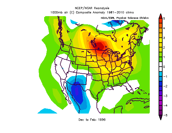
The above image is from the CFSv2 long term model. It shows the water temperature anomalies in the Nino 3.4 region. You can see currently it has it peaking around November over 2.5 degrees above normal (very intense). However, notice the crash afterwards as we head into winter. We should still have a strong El Nino for winter but it will be decreasing in magnitude. Other models are agreeing with this. For winter weather lovers I think that is decent news overall. Having an El Nino that is too strong makes for a more complicated winter forecast. We are all reminded of the Winter of 1998 which had one of highest El Ninos on record..
You can see the temps were well above average that winter. Now I will say the Pacific overall was different and the El Nino that year was more east based. Regardless, it is nice to see the models start to decrease our current El Nino just in time for winter.
Here are current Sea Surface Temps..
These were the Sea Surface Temps in Fall of 1997..
You can see the warm water in the El Nino region is more to the east in 1997 compared to currently and the pacific is warmer near California. That region will be key this winter, if the warm water currently gets too skinny then we could be talking mild. If it stays consistent and builds along with the el nino region staying more west, then we could be talking cold and stormy.
This among many other things is what I look at when making winter forecasts. Stay tuned for the forecast coming in October!
Thanks for reading.


Can you give us any idea of what Saturday afternoon (4pm) through 11pm will look like for this weekend? We are hosting a big block party and each forecaster seems to say something different!
ReplyDeleteLooking forward to winter and the VT slopes opening up!
Just saw your comment, we will see showers as we get later into today unfortunately. Not going to be ideal. Sorry for bad news.
DeleteThank you! We postponed until 9/26!
DeleteOn the winter front -- I see that Rob Guarino is saying warm December, average January, and blizzard February for NY metro area. Still a bit early, but doesn't sound too far out of line with what you are looking at here, Willy. Jim G
ReplyDeleteWinter is going to be very interesting this year, I am doing a lot of research and I just need to wait a few more weeks before posting my prediction. I want to see one more set of trends for the el Nino along w ssta in northern pacific. 1958 keeps looking like a strong analog.
DeleteHey Willy, maybe you already saw this or know about it, but for your readers, there's an interesting article on the baynature.org web site called "Don't Worry About the Blob", dated Sept. 1. The article basically sez that the big north Pacific "blob" of warm water off the West Coast is mostly a function of the "Resilient Ridge" over the coast. I had thought it was the other way around, the hot pool was mostly causing the ridge. An atmospheric scientist from U of Washington sez that some cross-Pacific cold water flows are needed for that ridge, and because of the big El Nino, they are diminishing. And so, this scientist anyway expects the "perma-ridge" to dissipate as autumn goes into winter, followed by the blob. Bringing some hope for rain in California. Would that diminish the Arctic air flows into the central and eastern US? Will be interesting to see. I suspect that this is one academician's theory, and others have different opinions. Interesting, nonetheless. Jim G
ReplyDeleteJust wrote you a long responce Jim but it was deleted. In a nutshell though its a "chicken or the egg" argument. I think this winter El Nino is def main driver. But the warm water off west coast will help enhance placement of the mean trough position off the west coast as opposed to having it bleed into the USA. With a ENSO that is trending more west (as of now, we will see if it continues) this could mean trough just to east of Aleutians and Ridge over West Central Canada. That leaves this winter still in the game. I think we can nail this down by October. Thanks for commenting.
Delete