Good morning everyone. Weather wise we had an excellent weekend with summer like temps on Saturday. As we look into this week temps will be more seasonal staying in the 70's in most spots. This will be due to a northeast flow of air from a stubborn area of high pressure that will be to our north for most of the period..
This will also keep our weather dry for most of the work week, so not much more to say here. Temps during the day will be in the mid 70's and lows at night in the 50's.
Now to the next issue. As this area of high pressure builds, parts of the jet stream will split under it and start to cause potential mischief in the long run. Think of the high pressure as a brick wall and any storms that develop under it stall and in some cases move back towards land. This starts to happen mid to late week as all models show an area of low pressure developing off the southern coast..
The low is unable to move too far northeast due to the blocking high pressure so it lingers. Now when you have a low lingering and ocean temperatures looking like this, you need to be careful..
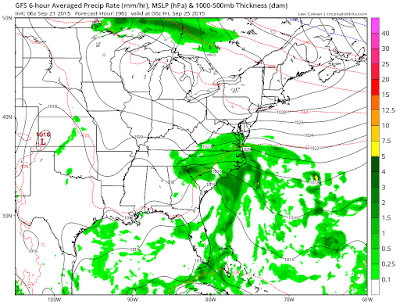
The answer is simple, the warmer than normal ocean helps feed developing storm systems by giving them a supply of moisture and heat which is critical to their development. It is because of this that we need to watch what this low pressure center does by the weekend. Here is gfs's projection for end of week..
It cant bring it too far north due to the high pressure but you can see it drifts the storm inland by Friday. This has the potential to cause an impressive rain event in the southern states. Other models are trying to show the same thing as well.
As we get into the even longer term this pattern does not want to let up..
As the upper level ridge shifts to the east we now have to look for development of storms in the gulf by end of this week/early next week..
Map above shows the blue area that represents low pressure and the reds that basically represent areas of high pressure. You can see the potential for something to develop under the area of high pressure.
You can see by Wednesday of next week the operational European model is hinting at a potential storm in the gulf..
Yes this is very far off but the pattern supports it and the European models ensemble system is also showing this as well. This means we will have days of model watching ahead of us. Again, the pattern is ripe for this type of storm development. Historically, tropical storms and or hurricanes have developed in patterns like this. That does not mean it will be the case this time, but it bears watching.
Stay tuned, more this week!


No comments:
Post a Comment