NEW JERSEY

...BERGEN COUNTY...
   FRANKLIN LAKES         7.5   532 AM  2/02  PUBLIC

...ESSEX COUNTY...
   ROSELAND               6.3   615 AM  2/02  PUBLIC
   NEWARK AIRPORT         4.2   700 AM  2/02  FAA CONTRACT OBSERVER

...PASSAIC COUNTY...
   WEST MILFORD           9.0   700 AM  2/02  TRAINED SPOTTER
   WAYNE                  7.0   700 AM  2/02  TRAINED SPOTTER
.MORRIS COUNTY... GREEN POND 8.1 709 AM 2/02 TRAINED SPOTTER BUTLER 7.8 635 AM 2/02 NOW MIXING WITH SLEET MARCELLA 7.6 800 AM 2/02 PUBLIC ROCKAWAY TWP 7.5 632 AM 2/02 PUBLIC BUDD LAKE 7.0 640 AM 2/02 NOW SLEET SNOW MIX LAKE HOPATCONG 7.0 600 AM 2/02 SOCIAL MEDIA NETCONG 6.6 545 AM 2/02 NOW MIXING WITH SLEET 2 E RANDOLPH TWP 6.5 700 AM 2/02 SOCIAL MEDIA JEFFERSON TWP 6.0 640 AM 2/02 SOCIAL MEDIA SUCCASUNNA 6.0 500 AM 2/02 SOME SLEET MIXING IN LAKE HIAWATHA 6.0 717 AM 2/02 SOCIAL MEDIA BOONTON 6.0 840 AM 2/02 CO-OP OBSERVER..HUNTERDON COUNTY... STANTON 4.0 516 AM 2/02 TRAINED SPOTTER WHITEHOUSE STATION 4.0 430 AM 2/02 PUBLIC READINGTON TWP 1.1 620 AM 2/02 TRAINED SPOTTER TEWKSBURY TWP 0.3 815 PM 2/01 SOCIAL MEDIA
Link to all totals can be found here
Feel free to share you snow reports, these are the latest as of early this morning for parts of nj
>>>>>>>>>>>>>>>>>>>>
The storm is unfolding as expected. Several inches of snow fell in northern regions and I am awaiting the final snow reports. I know here in Morristown, NJ we have just over 5" followed by sleet and now freezing rain. Speaking of freezing rain here is the current freezing level in purple..

Right now it appears its mostly freezing rain and the radar is showing that..

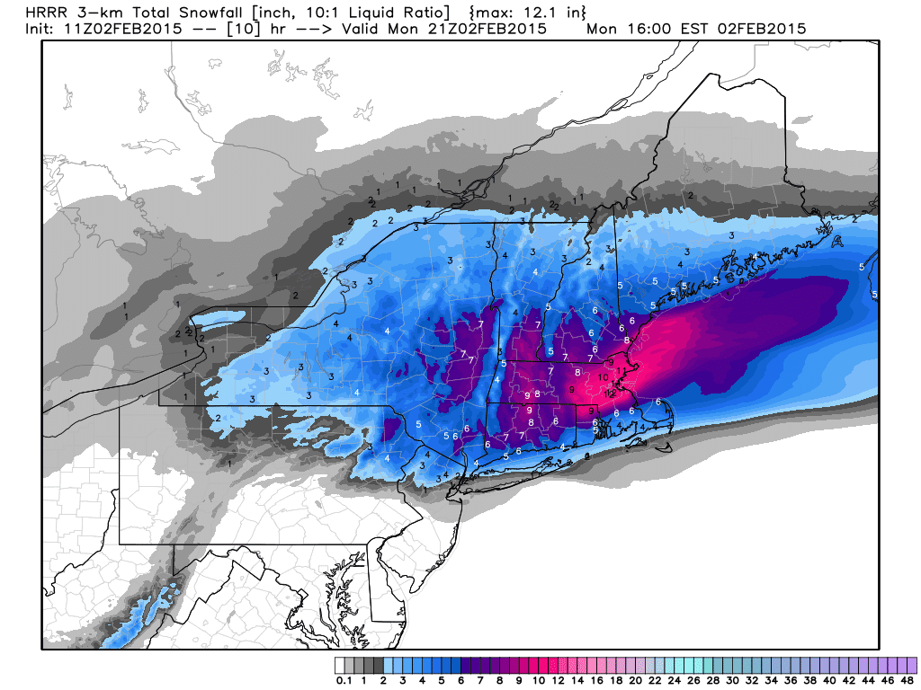
Snow is falling and will accumulate more today in southern New England.
If we go up to 5000ft in the atmosphere you can see the warm air filtering in as indicated by the red lines...

This causes the snow to melt before refreezing when it hits the surface.
By 12pm today the precip starts to finally move out from west to east..

Although, recent runs of this rapid refresh model are saying some snow can return early this afternoon and not leave until after 2pm due to some back filling precipitation as seen below..

It shows that a few inches of additional snow might fall during this period..
That would make sense as the storm will be pulling cold air back in aloft at that 5,000ft level towards the end of the event.
Overall the storm is going as I expected and I think when the final snow totals are printed they will be within my ranges. The jury is still out on that.
In any event, be careful today especially north of I-78 as some areas might never go above freezing.The weather pattern stays active for the foreseeable future and later I will focus on storm potential for later this week.
Thanks for checking in.
Should we expect more accumulating snow in the Totowa area
ReplyDeletepotentially some back end snow this afternoon but thats always hard to nail down..50% chance
Deletegood job on this one, your forecast was constant and accurate. what's with the self-considered weather experts on twitter who change their forecast every 5 minutes.
ReplyDelete