As for further south, especially in Northern NJ and NYC right now temps are below freezing with light precipitation. the 3-6 inch snow band I had (3 around I-78, 6 in extreme North NJ) will not verify. The cold air comes in as expected, but there is not enough moisture to make those accumulations fall based on latest model guidance. At this time an inch or two is possible before it is all said and done. You can see the void in precip on the model as we head into later today when I thought snow would break out..

I really thought some of this would fill in to produce some accumulating snow but you can see it is just snow showers at that time. Regardless, the forecast on the bulls eye of this time is not changed and those higher accumulations will fall up there.
We now turn the pattern for the next 10 days. I think the biggest theme here is going to be the extreme cold that breaks out later this week. I know its hard to believe but highs may only reach the single digits as we head into the weekend. For example, although this is prob overdone look what the GFS model has for temps on Sunday at 1pm..

Even if the model is off by 10 degrees look how could it still would be!
The GFS ensemble for the 5-10 day period look like this.

That purple color is up to 18 degrees below normal in C!
Here is the pattern that is producing this extreme cold below. You can see the massive ridge out west is allowing the cold air to literally pour in from the poll. Also notice the vortex sitting just to the north of our area..

Bottom line expect the coldest air of the season from Friday through early next week. Low temps will be in the negative for many areas.
So how about snow threats? Is it going to be more of the same or will areas further to the south finally get a decent storm? Well initally it looks like more of the same. The Boston area has two threats of more snow in the next 7 days as clippers dive towards the region and try to redevelop off the coast..
On Thursday clipper number 1 dives down and potentially explosively redevelops right along the cape..

We then again on Sunday see a similar scenario unfold again!!

- The highly amplified western ridge
- minor blocking developing over Greenland
- Pieces of energy splitting off of the polar vortex
It is something that I am going to absolutely keep an eye on for the next 10 days. In general, a reasonable person would say the Boston area is not going to get two additional major back to back snow storms and I would agree. However, I think we need to acknowledge that one decent snowfall is def possible over next 7 days.
Ok guys further south, this next part is now dedicated to you. There is some hope in the weather pattern as we get into next week..
This is a model projection for Tuesday into Wednesday of next week..
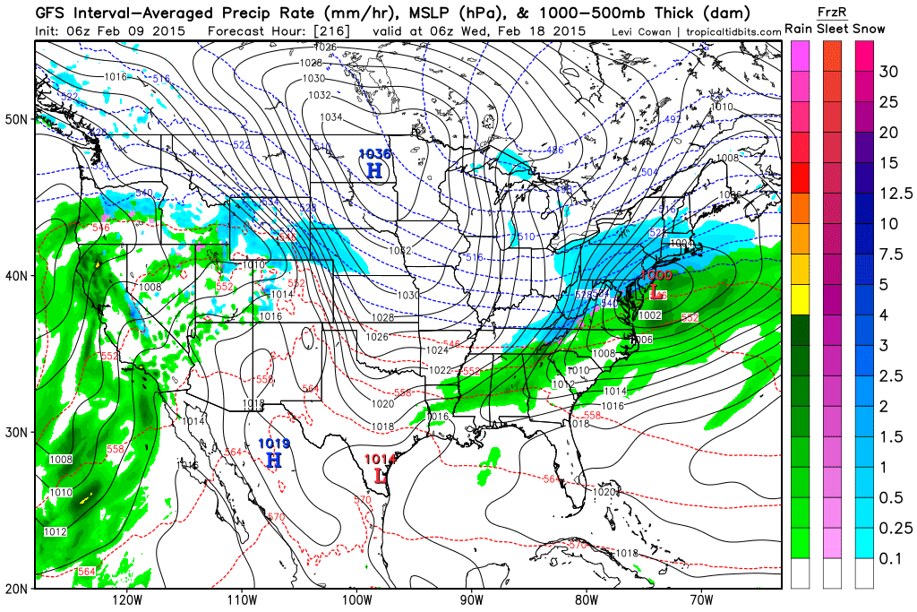
Ok so before everyone says your nuts "Willy" its over 7 days away you idiot. Lets take a look at the pattern because there is something very interesting going on during this period..

There is evidence and decent model agreement that the sub-tropical jet steam is going to come alive next week. This means that a lot of moisture rich air is going to flood into the nation. Normally this could cause a massive warm surge however, we have a big split flow in the jet stream. this means that we have a dome of arctic air locked into our region with warm moist air running into the cold dome. This is a classic set up for an overrunning snow event for the mid atlantic and part of northeast. I highlighted a lot of these features above. Notice how out west we still have that ridge that is causing cold air to funnel into the east downstream. The sub tropical moisture is undercutting that ridge. Also notice how I highlighted the dome of cold air over the east. The big vortex over southeastern Canada is also a key factor that needs to evolve as it would help anchor in the cold air.
Bottom line guys if everything comes together just right this is a very exciting and encouraging set up for snow lovers in areas a little further south of New England who got jipped so far this year. I will keep you posted on how this evolves.
Gunna be a busy week on the blog! Thanks for checking in.
No comments:
Post a Comment