WINTER OUTLOOK 2023 IS NOW LIVE

The 2023 Winter Outlook

Saturday, November 29, 2014

Saturday Morning Long Range Discussion: Evidence building on big mid month cold outbreak

Back on post on november 19th I discussed how the uptick in warming in the stratosphere was going to influence our weather pattern by the time the 2nd week of December rolled around. Since then, the stratosphere has continued to warm and it now will have effects on our December weather. Lets take a look at 50mb temperatures over the last month. This is basically mid way up in the stratosphere. You can clearly see the warming taking place up in the north Pacific into the Arctic..


 photo temp50anim_zps0ysnru21.gif
This has resulted in stress to the polar vortex and you can see evidence of a vortex split below at 50mb as seen by the two circles..


This should lead to very cold air if not another impressive arctic outbreak by the 2nd week of December. The models are really struggling with this, but some are starting to catch on. Below is the gfs ensemble forecast for December 8th,,


I pointed out a few key areas here. The trough south of Aleutian islands of Alaska is huge as that normally is the key to pumping up a massive ridge over the west coast into Canada and finally a big trough over the eastern part of the country. We saw this happen with our mid-late November arctic outbreak and I expect this pattern to continue throughout the winter. All due to stratospheric warming which is the result of many of the factors I discussed in my Winter Outlook 2015. 

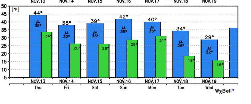
So enjoy the moderation in temperatures this week. Things could get quite nasty down the pipeline with bitter cold temperatures and frequent shots at snow.

More on Monday.


Thursday, November 27, 2014

Thanksgiving Morning: So How did my forecast make out?

Happy Thanksgiving everyone! Thanks for all the interactions and following yesterday, I really appreciate it and it makes this so much more fun to do. Hopefully to some extent I kept some of you ahead of the storm though my analysis this past 5 days. This storm was brutal from a forecasting standpoint. We had the air cold enough for snow in all areas above the surface, but surface temperatures were always the issue. I tried my best over the last few days to drive that point home especially I-95 south knowing that the margin would be paper thin between rain and accumulating snow. With that being said, lets call a spade a spade and say I did not take my totals down for areas along 95 and still had a general 2-5" band there. This did not verify and was a busted area of my forecast. The whole weather community including the pros had a tough time with this storm, but hey that's what makes this so much fun to track. Who doesn't like a challenge?

The goal of this blog is and always will be not to nowcast and instead evaluate all the factors that influence the weather or the development of a particular storm and take a stand on the issue with an actual forecast. Some might call that a little too bold and aggressive but I think its a rare thing these days. Just turn on the Weather Channel and watch them change their forecast literally every 12 hours. Whats the point of that? The weather is and always will be hard to predict which means the nature of my methods will result in failure sometimes. But you know what, this isn't my day job haha so that's ok to me. As long as I am right more times than I am wrong this blog will be a success.

So here where the final reported snowfall totals..


Below was my final snow forecast map issued Tuesday morning. I graded it..


So basically I got two regions wrong and was too high with amounts and three regions right where the amounts roughly fell in the ranges I had. Elevation was a huge factor in this! Hackettstown NJ at 500ft had 3.4" while a few miles down the road up on Schooleys Mountain at 1,000ft (where I was for the storm) had at least 8". That comes out to a 60% which is not a passing grade. 

But maybe you guys will give me some points for having this original map out on Sunday morning    ;-)..


I will let you guys be the judge and determine if that time value brings me up to a passing grade on this storm lol.

Stay tuned guys this is only the beginning. I am expecting a very active winter. Things should warm up a little after the next few days of cold, then based on many factors I look at, I think by the 2nd week of December winter comes and is here for real! I will start posting on the long range pattern tomorrow.


Wednesday, November 26, 2014

Live Footage from Morris County NJ at 1000ft! Heavy Snow Band Underway

Here it is my final update of the night. The heavy snow band you see on my twitter feed will work its way east and give areas that got short changed another shot at 1-3 inches! Tomorrow tune in for the verification of my snow forecast. Also we got a lot to look forward to in December so be sure to keep checking  in. Thanks for all the new followers I really appreciate it guys makes this so much more fun.


Final Video Update at 715pm..I got some live footage

Midday Video Update on Storm: Things are really starting to crank up

Quick summary of current evolution of the storm. Live footage later this afternoon!


Live Footage Coming This Afternoon

Wednesday Morning: Storm is Underway

******8:30am update: this storm is colder than expected already with sleet mixing in to the east and plain snow already in Morristown, NJ. Be on alert for travel as temps are decreasing rapidly. Looks like the models overestimated the warmth. Stay tuned!!******


Good morning. Our storm is now underway and here is a quick breakdown and what to expect. Expect frequent updates throughout the day and also on twitter which is linked to the right hand pane of this blog.

Here is our current radar..


That blue snow band with work its way to the south and east as the day progresses and temperatures fall. By 10am I expect north western zones to be changing over to snow..Elevation is going to play a huge factor here. 


As temperatures continue to fall this snow band works its way over towards interstate 95 by early afternoon


This is where travel should start to really diminish especially north and west. NYC and PHI I still think you are rain if not a mixed bag of precipitation at this time. Roads should not be bad yet in eastern zones.

By 3pm I expect the eastern zones to start seeing deteriorating conditions. In the image below red is snow..


Bottom line travel only gets worse as the day goes on from northwest to southeast. The big cities hold on to rain much longer before a changeover to snow this evening. Higher elevations north and west of 95 are the money zone for snow. Here is the latest high resolution model snow output which I like and think follows my forecast nicely..


As a reminder I expect 2-3 NYC, 7" Morristown NJ, Balt/Wash 3", 10" higher elevations of north west NJ, and 12+ near Worcester MA.

My going foreacst..


Remember for those who stay rain longer, that is expected and was build into my snow accumulations especially in the light blue zone. Your snow should not come till the end.

Stay tuned frequent updates throughout the day. I am now going to focus on the temperature profiles in everyones area and where the heavy snow banding might set up. Feel free to share any observations in the comments section or on twitter. 


Tuesday, November 25, 2014

Tuesday Night Weather Update: Hardest Forecast You'll Ever See

It doesn't get much harder than this to make a forecast for areas along I-95 and towards NYC. The gradient between no snow and 6 inches literally is going to be paper thin and I am not going to be arrogant and think I have it all figured out. I will say however I like the forecast I have been conveying to everyone over the last several days. I think it should work out well on a macro level, but on a micro level there are going to be many surprises. Thats what makes this so exciting to track! Some will get more snow than expected some will get less. For anyone over 500ft and especially over 1000 ft that really is a sweet spot to be as temps will be colder at the surface.

I will be updating twitter and this blog frequently tomorrow as the storm is underway with up to minute updates and maybe even live footage.

The video below discusses my points above along with other factors that will make or break heavy snowfall in your backyard.


Tuesday Morning: The Final Forecast

Good morning everybody, the storm is locked in and now its time to put out my final forecast. I basically took my original map from Sunday morning and made a few tweaks based on updated model guidance. Here it is..


Accumulations by major cities:

New York City:2-3"
Philadelphia: 4-5"
Boston: 4"
Baltimore/Washington: 3"
Morristown NJ: 7"
Long Valley NJ: (Northwestern NJ) 10"
Worcester Ma: 12+


Timing: Rain breaks out in most areas tomorrow morning. By the time we get to late morning there should be a rapid changeover from north to south to snow in many areas in the dark and light blue regions. Near NYC and the coast rain holds for longer. I want to note that elevation will play a huge factor in snow totals, below 400ft expect lighter end of my ranges. Travel will be at its worst during Wednesday afternoon into the evening especially North and West of Interstate 95 where this storm should be nearing its peak intensity. By the time we get to late Wednesday night the storm tapers off in most areas except for New England. By daybreak Thanksgiving we should be under calm and cool conditions.

This is a major early season winter storm that is bound to throw a few surprises to the upside and downside with intensity and amounts.I expect very heavy snow banding to occur which will cause brutal travel conditions at times and poor visibility. This is not a long duration storm but at its peak intensity will really pack a hard punch so be prepared.

Here is an example of the simulated storm getting close to peak intensity valid 1pm tomorrow


Keep checking in for updates, much more to come over the next 24 hours including an update tonight at 6pm!

Monday, November 24, 2014

Monday Night Storm Update: Major Early Season Winter Storm Imminent for Many Areas

The video below is my update on Wednesdays storm. The goal is to keep you guys ahead of the media madness that comes along with any approaching storm. The timing on this is Wednesday morning through Wednesday night. This is absolutely cleared out by Thanksgiving. As a note, for the central and southern areas the heavier the precipitation the more likely it will fall as snow. I will explain this process tomorrow.

Enjoy, the final forecast and tweaked snow map will be out first thing tomorrow morning.


Monday Morning Storm Update: Some Details Still Unclear

Good morning everyone. As we are now closer to the biggest travel day of the year, there are still some details that need to be sorted our for this storm. Here is my original forecast from yesterday morning and it has not changed..


This forecast is based on the fact that the storm tracks closer to the coast and some warmer air works its way into central and southern zones. That is why the accumulations are lower in those areas as things may not stay frozen the whole event. This is supported by the European, British and Canadian models. In this scenario, as I discussed last night, the travel headaches only increase the more north and west you go. Now no forecast is ever easy and there are always going to be variables going against you. In this case, the American models are colder with this storm. This would mean that the accumulations are more than what I have for central and southern areas, but not by a huge degree.

As an example below is the difference between the American, European, and British model on temps at 5,000ft which is a critical level for snow..Anything is blue is cold enough for snow, green and yellow is warm enough for rain

British Model..Supports my forecast of snow north and west of green zone


European Model..Supports my forecast


American Model...Does not support my forecast and is colder  as seen by the blue zone over all of NJ and low further off the coast. In this scenario the 4-8" band would have to be adjusted at least 50 miles to the south and east on my map. 


Bottom line I said it before and I'll say it again. I think you blend this to be 65% European model and 35% American model and you have your forecast.

I advise anyone who has travel plans Wednesday to be prepared for delays in all areas especially north and west. This storm starts in the morning and will only strengthen as the day goes on. By the time we get to the wee hours of Thanksgiving morning we are in the clear.

I will be updating on twitter all day and have another big update tonight at 8pm. If I have to change or tweek my snowfall map that will take place by tomorrow. The key today is going to be if the European model starts to trend east and colder to agree with the American model or vice versa. 

Stay tuned for the verdict!

Sunday, November 23, 2014

Sunday Night Special Winter Storm Video Update

The video update below gives a play by play of what I expect to occur with the storm on Wednesday. Things could still change of course but the goal here is to have an actual forecast to keep you guys ahead of the storm. The timing on this storm is Wednesday late morning until very early Thursday morning. The peak intensity should be from later Wednesday afternoon till late Wednesday night. Most of the travel headaches should occur north and west of interstate 95. I explain why in the video. 

I will update again tomorrow morning. Live updates are always on my twitter as well @weatherwilly 

Feel free to leave comments with any questions.

Enjoy..


Working on video now to break down this storm, it will be up at 730

Sunday Morning: Winter Storm to Effect Thanksgiving Eve Travel Wednesday

Good morning everyone. I now have enough evidence to support the prediction of a possible significant storm to effect the entire area on Wednesday into early Thursday. Snow will fall in many areas away from the coast and potentially several inches of accumulation are possible by the time Thursday morning arrives. Most areas should start off as rain before the changeover to snow, especially areas north and west of I-95. The good news is since we are very early in the season ground temperatures will be marginal at best for many areas which should help hold down accumulations. 

By nature this blog is always going to be a little more aggressive in making a forecast ahead of time. This means that there is always bust potential as public outlets will generally wait an additional 24-48 hours before releasing a real forecast. Since anyone can go to weather.com or weather.gov to watch those forecasts change everyday, the goal here is to study the factors take a stance and see how it plays out. That is the purpose of this blog. If my forecast turns out wrong which in some cases this winter they will, I will be the first to admit it. 

With that being said, here is my preliminary forecast map for the storm to effect the area Wednesday-Thursday early morning..


I think we might get lucky where this storm is mostly liquid for the day light hours on Wednesday giving folks a chance to get to their destinations. The further north and west you go the more chances at travel disruptions as a changeover should occur more rapidly. By the time Thanksgiving morning arrives I expect most areas to be in the clear.

In terms of model guidance the European model continues to be consistent and suggest this is a storm that hugs the coast. The GFS has corrected west but not as far west as the European. What you end up with is a warmer storm with more liquid on the European and a colder storm with less liquid on the GFS. I still like the 65% euro 35% gfs blend.  

I will break down the models later tonight and have a special video that breaks this storm down so be sure to check in 

Stay tuned to this evolving weather situation! 

Saturday, November 22, 2014

Sat Eve Update on Wednesday's Storm

I will make my first actual prediction tomorrow morning, but confidence is building right now for at the very least a moderate impact event. 


Saturday Morning: Euro Means Business for Wednesday

In my video last night I discussed the potential for a storm threat Wednesday night into Thursday. Yes, just in time for the holiday rush. I also mentioned another threat could materialize on Thursday night into Friday or the two threats could consolidate into one. Well, last nights European model run consolidated all the energy into one compact storm for Wednesday into Thursday effecting most of the area with snow.

The GFS has nada...

Huge difference in modeling here on such an important travel day! At this point, I think the best bet is to weight the European 65% and the GFS 35%. What does that mean? Well unfortunately it means there might be some travel impacts on Wednesday.

Here is my first estimate of what might happen. I really do not think you can fight the euro too much on this one...


I am not going to discuss potential accumulations because there is still the chance this storm does not occur at all, keep that in mind. By tomorrow however, I think I will have enough data to make an actual prediction. For those of you who are curious here is the European models snowfall output.


Read this with caution, this is not my snowfall forecast. The point is the Euro means business! Keep checking in, I am going to really stay on top of this one and try to keep you guys ahead of the situation. For many, the hope is that the GFS is right on this one, but how many times have we seen this routine- GFS out to sea, Euro further west. In many cases the euro does win but has to be adjusted a little to the east. 

Stay tuned, more later this eve.


Friday, November 21, 2014

Friday Night Special Video: Let the drama begin, storm threats showing up around Thanksgiving

The video below breaks down the potential setup for a storm system(s) to effect the east coast just in time for the Thanksgiving period. **This is still speculation and is not at prediction at this time, so do not be altering any plans!* 

If evidence builds I will turn this into a prediction if necessary. 

Here is a summary of the points in the video:

  • Rain storm hits the area Monday night brings in very warm air ahead of it and very cold air behind it
  • The cold air this storm brings in is key as it creates a boundary between warm and cold air along the coast
  • Based on the upper air pattern it is possible we see a storm develop on Wednesday into Thursday and/or Thursday night into Friday!
  • This is all going to depend on the timing of the disturbances in the jet stream
  • Cold air will be in place so if this storm develops then a lot of areas see a chance at accumulating snow

More details in the video below:


We Need to Keep an Eye on Late Next Week

Not jumping on anything yet, but I am closely monitoring Wed night-Friday  of next week for hints of storm development. I will have more info later this afternoon.  

Correction from this morning I put in the wrong days. 

Thursday, November 20, 2014

Thursday Morning: End of November Cold, Beginning of December Warmer

Just as a quick follow up to yesterday's analysis of the long term weather pattern. If I had to summarize my thoughts they would be as follows:


  • Bitter cold ends by Sunday followed by a two day warm up
    • This is due to a storm system passing to our west which will bring us rain on Monday
  • More colder than normal air returns just in time for Thankgiving
  • As we hit the 1st week of December temps should moderate with above normal conditions possible- This is what I consider a reload in the weather pattern
  • I expect colder than normal temperatures to return by the 2nd week of December where winter should then be in full swing
    • Hard to predict the magnitude of the cold at this time, but it should be noticable
  • There is the chance we see some snow before December, but I would put my chips on our first accumulating snowfall within the first 15 days of December.
Buffalo did reach out and tell me its sharing some of their snow if you snow lovers cant wait...


Wednesday, November 19, 2014

Wednesday Morning: Evidence of More Stratospheric Warming & It's Effect on December Weather

Good morning once again everyone. As we all experience these bitter cold temperatures, we are getting a taste of what can happen when warming occurs at the highest levels of the atmosphere. Many factors contributed to this cold outbreak, but a big driver was the warmer than normal temperatures we saw build up in the stratosphere (very high level of the atmosphere) late last month. As a reminder, when the stratosphere warms, it compresses the troposphere below it because warm air expands and the atmosphere cannot escape into space. When you compress the air below it causes the air to cool. In addition, it puts a tremendous amount of stress on the polar vortex which is basically a constant low pressure system over the pole where the coldest air in the northern hemisphere is held. At times, if the warming is significant enough it can cause this vortex to get knocked off it's axis or even split in to multiple parts. This is the phenomenon that causes major cold out breaks throughout winter. 

The warming that occurred in late October/early November was impressive, but was not classified as a Sudden Stratospheric Warming. A Sudden Stratospheric Warming in simple terms is stratospheric warming on steroids and is what normally causes this vortex to split. What is my point in explaining all of this? Well evidence is building that we will have a least another episode of stratospheric warming develop over the next few weeks. Whether it is significant enough to be Sudden Stratospheric Warming remains to be seen. In my Winter Forecast and my post back on November 3rd I discussed some of the drivers that increase the probability for stratospheric warming to occur. Some of these include, low sun activity which increases ozone in the upper atmosphere and wind patterns that favor the transport of heat from the tropics to the poles.

Lets start off by taking a look at the current transport of heat..


Just look at the red line and where is its in comparison to the green dotted line. If it is above the green dotted line that means there is an above normal transport of heat. This is the first clue that can tell us the stratosphere has the potential to warm because heat is being transported  up to the poles.

This is also supported by ozone continuing to build..


Now that we have a few factors established, we shift gears from current observations to model projections of strasopheric temps. 

Just focus on the area where you see the warm colors labeled by the "H". This is the projected temps currently in the first image and 240 hours from now in the second. Notice how the warm area expands and gets larger. This means the model is projecting the stratosphere to warm at this particular level of the atmosphere.  I can take you though the other levels but the message would be the same- models projections support the building up of warming.

So whats the bottom line for December? There is a 2-3 week lag from the time the stratosphere warms to its effect on our weather. Depending on the significance of this projected warming event will determine the severity but by the time we get to the 2nd week of December, overall warming favors below normal temperatures for most of our region. If warming event ends up being severe enough, it can lock in a prolonged cold pattern for winter due to the split in the polar vortex.

The fact we are seeing these factors develop so early this year is really building evidence that this winter might be no joke. In fact, I think we can all agree this current cold outbreak backs up that statement. 

A lot of forecasts are based on what the long terms models are projecting at the surface for temperatures. However, the model performance has been awful over the past month. According to the models, November was supposed to be a warmer than normal month. The opposite occurred and we are now flirting with one of the colder Novembers in history. That is why its important to look at other drivers besides the models. Looking at the stratosphere back in late October would not have led you wrong and I think looking at the strasophere now for Decmeber should result in the same. Lets see how this evolves in a few weeks.

Temps stay very cold until this weekend where we get a nice warm up. By the time we approach thanksgiving, things cool down again. I do not see any storm threats to jump on at this time. I expect the pattern to reload a little over the last week of November and even the 1st week of December. This means temperature can moderate (evidence of this supported by MJO) before round two of cold occurs around the 2nd week of December. 

Thanks for checking in. 

Tuesday, November 18, 2014

This Morning It's all about the Cold!


This image is a graphic from weatherbell.com. Take a minute to look at what this is showing. On the pane on the right you can see what the breakdown is of the temperatures over the entire United States as of 7 am.  85.3% are at 32 degrees or lower! That is the coldest November morning since 1976! You can't help be be impressed by the strength of this historic arctic outbreak.

Now relative to averages, this will be hard to repeat this winter. I do however think that we  see frequent outbreaks of cold as we go though the winter months. All due to episodes of stratospheric warming that I discussed in more detail back on November 3rd. The factors that drive this warming are discussed in my Winter Outlook.

Here is the updated summary of temperatures for the rest of the week. 


This impressive cold lasts until Sunday where things really warm up nicely. Why? Because a storm system is going to pass to our west which brings a southwest wind into our area...


Now as for Friday, at this point we might see a few flurrys. There are no winter storm threats on the horizon over the next 7 days. The weather pattern should start to relax a little before reloading after the 1st week of December.This means temperatures will be closer to averages.

Once we hit December, the word snow is not as rare and based on how I think the winter will go, I think we see our first shot at a wide spread accumulating snow event. Remember I am expecting two big storms this year (accumulations of 10 in or more) by the time its all said and done. It's not easy to get one big storm let alone two. So lets see how this all plays out, its a bold call. 

Towards the end of this week, I am going to start focusing on Thanksgiving weekend's weather. 

Monday, November 17, 2014

Monday Morning Weather Discussion

Good morning, the video below takes you though the next 10 days of weather. Here is the summary:


  • Rain ends later tonight
  • Bitter temperatures move in tomorrow and last though Friday
    • Some places might not break 30 for highs
  • There will not be any moderate or big storm Friday, however we can not rule out a light snow event
    • The models do not show that at this time so we will see if they evolve to this idea
  • Moving into next weekend, things warm up by Sunday as a big storm system passes to our west and effects the central part of the country early next week
  • Looking into the longer term I think the overall colder than normal weather pattern continues although things will moderate a little.

More detail in the video below...enjoy


Sunday, November 16, 2014

Sunday Morning Message

Good morning. Rain comes in tomorrow, then brutally cold temps for the middle of the week (given this time of year).As we approach Friday, I have been closing watching for a potential snow event. I am going to review the models today and will have a post tomorrow morning that gives more clarity on the situation. 

This is still not a prediction yet, it is speculation. However, by tomorrow I should know a lot more. 

Stay tuned. 


Friday, November 14, 2014

Friday Morning: Higher Elevation Saw Nice Taste of Winter Last Night, Very Cold Conditions Underway

Well the snow fell yesterday in most areas but only really accumulated above 500 ft. In the higher elevations of NJ, 1 inch fell in many spots with as much as 3 inches in local spots. Not a bad way to start the snowfall season at all. 

The theme moving forward over the next week will be the sustained cold...

Here are temperatures departure from normal in Celsius over next 7 days...


Everyone is really going to notice the chill by early to mid next week when temps don't even break 40! You can see the vortex like feature near our area at that time..


Here is the updated GFS models projected high temps each day for North Jersey, other areas will see similar temps I am just using this as a proxy..


So for those of you who have been reading you see how the factors discussed back in My post on November 3rd led to this. Expect this process to repeat a few times this winter leading to frequent arctic outbreaks. In between, the pattern should relax at times. There is evidence of the pattern relaxing after the ten day period, but I don't think its anything to write home about.

By the way, as this cold pattern finally does try to relax a little end of next week we still need to be on alert of a possible storm to develop. As a note, when I speculate on long term storm threats take it for what it is speculation. I will actually give an opinion when we are within the 5 day period. 

But in any event, we still have evidence of a jet split middle of next week..


No projected storms on the map for end of next week, but we should keep monitoring this period.  Remember the storm system early in the week I expect to be a cold rain. So nothing to get excited about there. 

Stay tuned. 


Thursday, November 13, 2014

Thursday Night: Snow Will Wind Down by 12am

See twitter feed for updates. Snow levels are dropping now closer to 200ft. All elevations over 700ft in NW NJ will see 1-2". More tomorrow. Thanks for following guys 

Let it Snow!

Good Thursday morning everyone. Well it might not be too impressive but we will see our first flakes tonight! That definitely pumps me up for the winter season. So I know I have been mentioning the shot at snow showers or flurry's all week, but this is going to be slightly more than I expected for some areas. In any event at least the models came around to the general idea. Here is my forecast. 

I think most areas see flakes but the areas where it will cause a coating or an inch or two will be in the areas I highlighted.

Oh by the way, the cold air is here now at well..

Here are temps as of 7am..


High and low temperatures projected over the next week..


So I was not joking early last week when I said the cold air would arrive here.

So how about that storm early next week? Now that we are within the five day period (that's always when I like to take a stance on what I think will happen), I can give you my prediction and say its going to mostly rain! Yes there is still the chance northwestern counties can see some frozen precip from the storm, but overall I am not impressed with the set-up.I broke down the reasons why back on Tuesday Night's Video Discussion. My thoughts have not changed on that.

The cold holds through at least next week and unsettled weather is possible at the end of next week. I will focus more on the longer term tonight or tomorrow.

Thanks for checking in. 


Wednesday, November 12, 2014

First Flakes Now Likely Late Tomorrow Night/Friday Morning

Its good to see the models start to show at least one of my ideas this week. We will in fact see our first snow flakes! This comes in the wake of the cold air finally arriving tomorrow. Say goodbye to temps in the 60s!


Expect very minor accumulation as in mostly a dusting. Some areas may see up to an inch!


I will focus on Monday's situation as well as the longer term tomorrow morning. 

Nothing to Add this Morning: Thoughts are the Same

Cold arrives tomorrow,light snow late Thursday night into early Friday, rain early next week (snow interior), and need to keep an eye on later next week.


Tuesday, November 11, 2014

Tuesday Night Detailed Video Discussion

Video below gives a more detailed view on my thoughts on the potential for snow after studying the models over the last few days. 

Bottom Line:


  • I still think we see flurry's on Thursday night into Friday
  • Based on the upper air setup of the weather pattern, I am leaning more towards rain for the mid Atlantic states and snow inland for early next week. 
    • So the storm threat I discussed back in Thursday's Post looks like it will occur, just not snow for the mid Atlantic
  • End of next week we then have another shot at a storm system that we have to monitor.
  • The cold air will arrive at the end of this week and last possibly into Thanksgiving
    • Confidence is high on that
Last thing I will say is none of this is a final forecast yet considering early next week is still 7 days away. I just do not like the way things like at this time for frozen precip. That of course can still change. The pattern is active and that's a start. For you snow lovers out there remember its still November! Getting a big storm is hard enough in the dead of winter let alone in the late fall. 


Tuesday Morning Video Discussion

Video below summarizes the weather pattern over the next 7 days. The focus is on the cold coming to town later this week (holding at least until thanksgiving) and potential snow threats. At this time I think the first flakes of the season are on early Friday morning (snow showers or flurries) and our first shot at accumulating snow is early next week. However, this is far from a certainty and I have many concerns.

For those of you more interested in the finer details including those concerns, I am putting out a special video tonight around 7 pm so be sure to check in. As always, when this storm threat enters the 5 day period I will start to take a stance on what I think will happen.


Monday, November 10, 2014

Monday Morning Weather Discussion: Will It Snow?

That is the million dollar question right now and as always it is very difficult to answer on a micro level. On a macro level anytime you see a model projecting snow cover to look like this by next week, you know at least some of these areas will experience the white stuff..

Now the problem is if you read this map verbatim then you get into a lot of trouble. All this tells me is that we have a lot of cold air and moisture on the playing field which gives us the chance at storms to develop. Given the fact that we have to deal with the polar vortex meandering around south central Canada for most of this peroid its the cold air that actually in the end can suppress some of these snowfall opportunities. I will explain this below.

Before I focus on the main peroid which is early next week, lets not forget about the chance to see the first snowflakes of the season for many areas Thursday night into Friday. At this time it looks like at least flurrys are likely but weather we see any light accumulations remains to be seen. The european model is the most aggressive giving our area up to an inch of snow..

Very hard to determine if this will be realized as the other models are more suppressed with this light snow threat. The reason I am showing it is because I still do believe this can happen and the threat is alive. I will keep you guys updated on this.

Lets turn our focus back to the main period which is early next week. Most of the snow you see on that first map is based on the assumption that our area sees a larger storm at that time. But what factors do we have on our side, and what factors do we have against us for a storm.

The first factor is the cold air. Expect the colder temps to arrive by the end of the week after mild conditions this week (little slower to arrive that previous forecasts).. Once the cold air is in place we then have moisture that will try to run into it due to a split flow in the jet stream developing..

Now my concern is that the cold air presses a little too hard and suppresses the big storm threat out to sea next week. The map below shows a few factors..

First the positives. We have a area of high pressure over Greenland (negative NAO), a ridge out west and something called a 50/50 low that looks like it wants to develop. All those factors are supportive of a storm developing as they steer the jet stream in a favorable direction- especially when we have that split flow shooting moisture into the country. However, you can see part of the polar vortex sitting over central Canada. This is a double edged sword. It supplys the area will the cold air needed to create a boundry between the moisture to the south and the cold air to the north (baroclinic zone) but if too strong it can act like a foot and squash any developing waves along that baroclinic zone out to sea. Thus, making a forecast 7 days out is extremely hard.Right now the models says the wave of low pressure develops in a favorable area for the mid Atlantic to see snow next week..

With so many moving parts I would be guessing to put out a forecast at this time. It is something that I am going to have to keep breaking down over the next few days.

I will take a stance on the Friday situation and say I think we see our first flakes and that the European model has the right idea. 

Stay tuned and enjoy the last of the milder weather the first half of this week!