Tuesday, December 31, 2013
Happy New Year: Forecast On Track
Nothing to add till tomorrow morning. Happy New Year! Thanks to everyone who checks in.
Tuesday Morning Storm Update
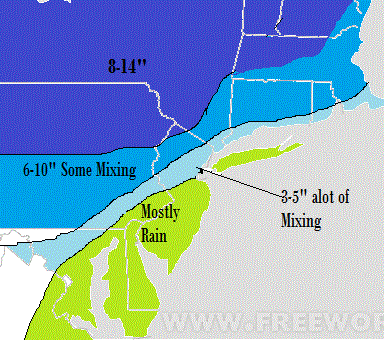
Video below describes my updated thoughts on Thursday-Friday storm. This will be a moderate to heavy snow event due to the very cold air resulting in high ratio snow. However, my original ideas of a wind driven blizzard are not AS likely at this point due to latest model projections. What the result should be is my snowfall amounts posted yesterday being accurate but the intensity being less which means not as much wind or intense bursts of snow. I want to make the point that this is a very hard forecast meaning things can still change over the next 24 hours in either direction.

Updated Snow Map:

Monday, December 30, 2013
Updating Things Tomorrow Early am After Tonight's Models
This mornings initial thoughts are below. Snow map is a broad estimate and will be either reduced or increased based on trends in next 24hrs
Potential Big Storm Thursday into Friday
Quick afternoon update: new European maintains my idea of major snowstorm for whole tri state area. Media frenzy imminent, Weather Channel clowns included. Next update late tonight.
<<<<<<<<<<<<<<<<<<<<<<<<<<<<<<<<<
One model really jumped on board to my overall theme last night. I go into detail on timing and have my map of potential snow amounts with this storm in the video below. I am going to take a stance on this, lets see how I do. I will focus in more detail on amounts by tomorrow if necessary.

Next Update Tonight.
Sunday, December 29, 2013
Video Update on Storm for Thursday/Friday
What we know now is that a storm will occur somewhere from Mid Atlantic north. It is now just a matter of where it develops and intensifies. I discuss the dynamics behind this storm in video. I will make a prediction and produce a map on this once more data comes in by tomorrow morning. I am leaning towards this correcting to give the NYC North Jersey area a more intense storm than shown on models.
Saturday, December 28, 2013
Let the Media Hype Begin: Here We Go, My Ideas are Now Showing on European Model
For those of you who have been following daily you know I've been talking about a major pattern change since before Xmas. I also mentioned I thought around the New Year the pattern would be ripe for a major storm. Models have been in absolute mayhem over the past few days not able to agree on everything. The model ensembles however, which basically test the model for errors have been hinting at a potential major storm for the end of next week. I outlined yesterday what had to come together in order to produce a major east coast storm. It all comes down to the phasing of the jet streams and placement of high pressure. When we are 6 days out from an event, the models do not have to change much for the surface solution to change drastically. There is now evidence that is starting to occur based on the latest model guidance.
The latest European model now phases the jet streams over the east coast, producing a significant storm. We are still 6 days away so a lot will change but I am confident we will see a major storm. Here was the European yesterday...

Latest run:

Blows up a major storm just off of cape cod and gives tri state area a lot of snow to. So why such a drastic change? It basically all has to do with the speed and timing of the upper air energy in the jet stream I discussed in yesterdays post. Change those variables just a hair and you have a major shift at the surface like you see above. That is why to predict weather with more accuracy you need to understand what can change not just what the model prints out at the surface. Any 5th grader can read a surface model printout. All week I saw the potential just based on what was going on in the overall pattern, which was first discussed back on the 23rd in my post.
So is this storm a guarantee, of course not, a lot will change in next 6 days along with the media circus that will inevitably start hyping up this storm. But I will say I think we have a good shot at this one. We will have very cold air in place, an active sub tropical jet stream and upper air high pressure in an optimal spot that historically has given us great storms. Other model guidance including the GFS and Canadian are also starting to trend towards my ideas as well.
Snowfall amounts could be large with this but I will not mention amounts yet or show some of the impressive amounts the European is printing out just because it is too early and premature to do so.I will focus on that if this trend continues over the next 36 hours.
Frequent updates now will now be posted as more data comes in. Be sure to check in and encourage others to visit www.weatherwilly.blogspot.com to keep them ahead of the necessary or unnecessary media hype.
More late tonight.
Friday, December 27, 2013
Closer Look at POTENTIAL January 3rd Storm Threat
I will be the first to say this is very speculative, but I am closely flowing a potential large storm for the January 3rd time frame. There is not full model agreement on this nor does anyone at this time have confidence this will occur. However, lets look at the reasons behind why.
Before we get into the situation on the 3rd, a cold rain storm will effect our area on Sunday night..

The cold polar jet stream is not going to feed this southern jet stream disturbance which results in a warm solution for most areas.
So moving on to the 3rd, the GFS has been the only model that has picked up this storm. Here was run from this morning..

982mb low (very strong storm) that would really hit the Northeast hard with snows. Don't worry about the rain snow line at this point, we need a storm first before we can determine who gets what. The model has NOT been consistent with this solution and we all know you cant go by one run of the models, however, lets look at the upper air ingredients that we need for this storm to come to fruition.
GFS is showing bigger storm because it try's to hint at phase of all three jet streams as shown below. I outlined the jet streams in red. Arctic is on top, polar in middle and southern jet on the bottom.

The european model which has no storm does not phase anything for this time period...

Notice the blue spot over southern Texas. It is holding energy back there and accelerating the other two jet streams ahead of it resulting in a flatter no storm solution.
Given that we are a full week out a lot will change with this and I am not ready to dismiss this potential very large storm. For one we will have a negative NAO (high pressure over Greenland, good ingredient for east coast storms) and a positive PNA (ridge out in west). You can see this below..

Of course just because these are present does not guarantee a storm to develop. The point I am trying to make is the atmosphere is very capable by this time to produce that big storm. It will be interesting to see over the next few days how the models trend and if they loose this threat completely or start to converge on a solution.
I'll update as more data comes in. Stay tuned.
Thursday, December 26, 2013
Tuesday, December 24, 2013
Last Second White Christmas?
North Jersey might see a dusting of snow tonight as a few scattered snow showers will try to make their way into the area just in time for Christmas eve. You can see simulated radar for tonight below..


Some models show it but out to sea (January 1st)..

Lets see how this plays out over the next few days and if a stronger storm ends up being projected. We are still a week away. In any event, Merry Christmas! Tomorrow will be a cold day with hopefully a dusting of snow on the ground.
Looks like a few areas can get lucky, but by no means is this a wide spread event. After tonight the next 5-10 days look like this temperature wise..

This is due to the pattern shifting like I mentioned last week. Notice the models still have blocking high pressure over the top and cold underneath (great winter pattern)..

The polar vortex will be trapped over eastern Canada. We might rival the cold January of 1994 with a set up like this. Here is what the temperature departure from normal was back then..

Now all we need is some southern jet stream energy to phase along the east coast like I have been talking about..
Some models show it but out to sea (January 1st)..

Lets see how this plays out over the next few days and if a stronger storm ends up being projected. We are still a week away. In any event, Merry Christmas! Tomorrow will be a cold day with hopefully a dusting of snow on the ground.
Monday, December 23, 2013
Monday Morning Quick Summary
Good morning. My thoughts have not changed since my last post. Cold air arrives tomorrow with maybe some snow showers heading into Christmas. The cold air locks in for the next few weeks and should ripen the environment for a few storms to develop. I still have my eye on around the New Years time frame for possible storm development. I will provide a new perspective on this threat probably some time tonight or tomorrow morning. Enjoy the last day of warmer weather, winter is almost back.
Friday, December 20, 2013
Buckle Up Winter Will Be Back and Here to Stay
Good Morning. After this weekends warm up, all signals point to winter making a sharp return for late December through January. All the ingredients needed which include the temperature profiles of key areas of the oceans, an active sub tropical jet stream, and high pressure developing over the north pole to drive arctic air southward are in the process of developing. What this will result in is frequent injections of fresh arctic air over the eastern third of the country with warm moist air running into it from the subtropical jet stream. You can not ask for a much better set up if you are a winter lover.
Here is what the atmosphere will look like the days following Christmas into the new year..

What looks like a bunch of different colors is a winter lovers dream over the east coast. Basically what you see above is blocking high pressure developing over Greenland and the North pole shown in red. This is a negative North Atlantic Oscillation and Negative Arctic Oscillation. This high pressure forces the semi-permanent polar vortex (the polar vortex is the constant area of low pressure that sits and rotates over the north pole, it is the coldest air in the northern hemisphere) into eastern Canada and the eastern US. You can clearly see the polar vortex on the map above in the purple and greens.
So think about what you see here. A massive area of cold air just sitting over our area, to the south and west of it you have a live feed of moisture running into this cold air which is the sub tropical jet. You can see the sub tropical jet below that has been constantly been present for weeks..

I cant think of a much more ideal set up for cold and storms than what you see above guys. In terms of storms, looks like we might have a shot at a post Christmas storm along with another shot around the New Year. I will have more on that potential sometime this weekend. But for now the point need to be made that Winter will be back and back to stay.
Thursday, December 19, 2013
Keeping my Eye on Middle to End of Next Week
After this warm up the weather pattern might have some potential from Christmas on. Not ready to jump on anything yet. I threw a few hints in yesterdays post, but I still want to see a few more things before I go into details. Stay turned.
Wednesday, December 18, 2013
Who's Dreaming of a Green Christmas?
Get ready to fire up the grills this weekend, here comes a blow torch. If you like the snow I would spend some quality time outside today because by Xmas morning its gone. Not only will temps reach into the 60's this weekend but we have a nice rain storm to put the nail in the coffin on its heals. Oh it will cool down again but not until the rain throws the hay maker on Sunday to ensure all the snow is gone.


Check out the temperature departures from average this weekend
If you cant see that clearly that's anywhere from 15-30 degrees above normal for Sunday. Now here's the final blow...
Once this rain clears the area sometime Monday it will get very cold again but below is the damage to the snow pack...
BEFORE (Today):
AFTER (Xmas):
I think I made my point. So is there any good news before we bring in 2014? Maybe. I am monitoring a potential favorable setup for a storm system to effect our region New Years Eve time frame. Here's what I am looking at..
You see a storm over eastern Asia by tomorrow..

A general rule is that storms that form over eastern Asia (shown by the blue and green over Japan) generally will resemble conditions along the eastern part of the USA 6-10 days later. The image above valid Friday the 20th, brings us to the 26-30th time frame for a possible storm. Lets see what the models project for that time..

Generally although the forecast is diluted because it is the average of many different trials, it looks like its favorable with a trough over the east and ridge to the west. Only time will tell. The GFS in its fantasy range (anything outside of 7 days) likes the idea valid New Years Day..

Time will tell. As always I will keep updating on this pattern.
Thanks for checking in.
Tuesday, December 17, 2013
Monday, December 16, 2013
Monday Eve: Summary of Clipper System Tomorrow
2-5" is what I expect tomorrow over our area. Snow will start before dawn and only last into early afternoon (if that). This is a high ratio snow event so it wont take much liquid to have the snow stack up. Roads will be slick for the morning commute so take your time. I am still keeping my eye on xmas week after this weekends warm up.
More in the coming days.
More in the coming days.
Sunday, December 15, 2013
Summary of Saturdays Snow Storm & A Look at the Week/Month Ahead
7am Morning Update: I expect snow to spread into the area tomorrow morning and last into early afternoon. This is coming from a clipper system out of Canada. We will see around 0.2-0.3 inches of liquid with this system, but since it will be so cold aloft expect 15-20:1 snow ratios for North Jersey and NYC area. That leaves us with a easy quick few inches of light fluffy snow. If this system throws us any surprises it will be to the upside w snow amounts. Video summarizing weekend storm and weather pattern ahead below.
<<<<<<<<<<<<<<<<<<<<<<<<<<<<<<<<<<<<<<<<<<<<<
Overall although it was spottier than I expected my snow amounts where hit the general areas I targeted. I will show this in the video along with discuss the light snow event coming on Tuesday and a look at the rest of December.
<<<<<<<<<<<<<<<<<<<<<<<<<<<<<<<<<<<<<<<<<<<<<
Overall although it was spottier than I expected my snow amounts where hit the general areas I targeted. I will show this in the video along with discuss the light snow event coming on Tuesday and a look at the rest of December.
Saturday, December 14, 2013
5pm Video Update on Tap
This storm is not a bust! Heavy precip was never supposed to arrive until this eve for north Jersey. My snow map remains in tact. Here is latest radar..


As you can see the heavy precip is still down in MD and will work its way up to our area by dusk. That is when most accumulations will occur.
Video at 5.
Friday, December 13, 2013
Thursday Night: Play by Play of Tomorrows Event
9am Update: Everything outlined in video below. Models came in a little warmer with the storm last night especially the NAM model. However, as we saw last Sunday the modeling has had a very hard time handling dense arctic air masses. If fact, if you look at what the model projected the temperatures to be at the rain/snow level (5000ft) and what those same temps actually are at 7am, there is not a match. The model is a little warmer. This is why I am not changing any of my forecast ideas for this event. Light snow has spread into area but the heavy accumulating snow will be be until late this morning/afternoon. I will be doing an afternoon video update around 2.
<<<<<<<<<<<<<<<<<<<<<<<<<<<<<<<<<<<<<<<<<<<<<<<<<<<<<<,
For areas in the middle zone of 3-5 its all going to depend on how long the arctic air holds if modeling under estimates it you will get more snow than shown. I will know more on that tomorrow morning. And if for some reason you prefer to use other websites for your weather info at least go to the national weather service at www.weather.gov, The Weather Channel is really nothing more than a commercialized news company now, its a joke how they present things (naming winter storms for example). They have changed their forecast 5 times since Thursday.
Heres the map that goes along with video
More to come tomorrow morning. Frequent updates on my twitter www.twitter.com/weatherwilly
Friday Morning: Still holding my Original Snow Map
Good morning, I see no reason to change my snowfall amounts for tomorrow's storm. Timing will be from late Saturday morning/early afternoon depending on where you live to Sunday morning. Models have been trending to higher precip amounts with the storm. However I am keeping my map BC it looks like some mixing should occur even in NW Jersey so that will keep amounts in my 5 to 8 range for there. If this stays all snow in Northwest NJ then we would see closer to a foot of snow. Central Jersey starts snow then changes over later sat night. South jersey Delaware MD all change to. Rain eventually. I am traveling but will have a play by play breakdown of the storm later tonight probably around 10pm
My original standing snow forecast from Wed morning is below in yesterday's post. When I have time tonight I'll put more detail into it.
Video at 10pm.
Twitter site is www.twitter.com/weatherwilly
My original standing snow forecast from Wed morning is below in yesterday's post. When I have time tonight I'll put more detail into it.
Video at 10pm.
Twitter site is www.twitter.com/weatherwilly
Thursday, December 12, 2013
Thursday Morning: My Snowfall Map for Snow Event
Good morning, my confidence is high on a moderate snow event to effect parts of the area from Sat afternoon into early Sunday morning. As I have been talking about a lot was banking on both storm systems phasing to produce a big storm. However, a phased solution would of likely produced the accumulating snows father North into mostly new England. The solution I am going with is a middle ground. The two disturbances will not phase but instead keep most of North Jersey cold enough to snow for the duration of the event. To boot, there will still be a lot of Moisture available as the second non phased wave will still add to the initial precip totals from earlier Saturday afternoon. So what does this all mean? It means my thoughts on my map yesterday morning I am sticking with. Here is that map with timing and I will write in my snow forecast below.

Dark blue area: 5 to 8 inches
Light blue area: 2 to 5 inches the closer to the dark blue you get (morristown)
Green Area: little accumulation
NYC will see some accumulations out of this prob around 3.
Baltimore DC areas a few inches possible as well.
Stay tuned for frequent updates. If i have to update map it will not be until Friday. At that time I will have more detailed projected snow bands as some areas will be in the 1ft range. I like to hold a forecast if I can unlike the weather channel.
Wednesday, December 11, 2013
Quick Afternoon Update
The latest model trends for the weekends storm system. Most people see snow on Saturday on the order of a few inches before the main storm decides if it wants to develop. Two previous posts discuss my initial thoughts. Will put out a final forecast before the weekend. Details below.
Wed Morning: Map for Weekend Storm
Details on this weekend system are explained in last nights video. Overall I like the ideas I laid out and will make my final tweaks before the weekend. No reason to flip flop, a lot of time before storm arrives. Below are my initial thoughts on the impacts from this system. Red curves are when I expect precipitation to start.

Next update on modeling coming later this afternoon or tonight.

Next update on modeling coming later this afternoon or tonight.
Tuesday, December 10, 2013
Snow is Underway
Snow has broken out for most of the region coming down pretty moderately. This will be a quick hitter but carry quite a punch. Snow ends by mid afternoon. Some areas will see impressive amounts where there is strong banding and possible thunder snow, but overall I like the map I have from last night. I am not going to keep changing the map every 3 hours like some other places. Check in later for summary and more details on potential for weekend storm. Follow me on twitter https://twitter.com/weatherwilly for more frequent updates.
Monday, December 9, 2013
Snow Map for Tomorrow: Video Update First Thing In Morning

11pm: Will have video up by the early morning. It will be snowing by dawn.
Monday Morning: Summary of Yesterday and Looking Ahead to Tomorrow/Next Weekend
Good morning. I want to start off by taking a look at the final snow totals from yesterday

Large spread 1-2 inches over most areas, but where this storm threw everyone off was that narrow band along northern Delaware and south central NJ that produced 6-12 inches. What ended up happening was the cold air to the north was stronger than modeling had expected and it caused a strong area of accelerating upward air in the region where the cold air met the warm air.
Here was my map

As you can see I was dead wrong over the areas that where in that narrow band but the rest of the areas received the snow I expected (1-2 inch range).
Looking ahead into tomorrow we have another wave of low pressure that will cause snow to effect our region. This is at 1pm tomorrow.

Snow will break out late morning and last into the evening. I expect accumulations of 2-4 inches over most areas with locally higher amounts. Rain will not be a concern as cold air will be in place and the low will track just to the north east off the coast. Here is what the modeling is printing out for snow totals.

Not a complicated set up pretty straight forward. Roads will get slick tho.
Now in the longer range we have to monitor a potential situation for the end of the weekend. This would be a much larger storm threat than what we recently experienced

Below are the ingredients for this system which need to come together just right. Both jet streams need to phase and there has to be enough ridging to the west. If this all does come together we would have a big Nor'easter on our hands.

More on this potential in the days to follow. Right now its all speculation as we are 6 days away.
I will put detailed snow map out tonight for tomorrow's event when I have more time.
Sunday, December 8, 2013
130 update: Storm is Suprising Everyone Near Phili
All Amounts have been adjusted upwards by National Weather Service
Saturday, December 7, 2013
Play by Play of Tomorrow's Winter Weather
10am Update: I like what I have below, major operational models hold the accumulation ideas in line. The short term high resolution models however are a little more optimistic on snow amounts or areas north and west. These same models did bust however on Friday night so it will be interesting to see what happens. I will update throughout the day on this page so check in.
<<<<<<<<<<<
Below is video with my final thoughts on tomorrow. I took down some of the snow and ice amounts from yesterday. Details in video. Timing is from tomorrow early afternoon starting in the southern zones ending Monday in the northern zones on map.

Friday, December 6, 2013
First Stab at Winter Weather Effecting Our Region Sunday Night
QUICK 430PM UPDATE: Everything looks on track. Flakes should fly tonight mostly accumulating in northwest Jersey. Will keep and eye on Sunday and cut video tomorrow. Also note totals on map below are for both events combined.
<<<<<<<<<<<<<<<<<<<<<<<<<
Good morning. This weekend I will cut the usual play by play video of how the event will unfold, but for now here are my preliminary thoughts on what to expect with the wintery precipitation that will effect our area possibly tonight then again on Sunday night. For most areas the main concern will be icy roads before the inevitable changeover to rain late Sunday night. Our far northwest counties into PA will receive the most snow and ice before it ends as rain. Here is the precipitation map starting tonight.

As you can see mostly rain tonight, but northwest NJ into Pa will see some back end snow. Any light accumulations will be in those areas especially over PA.
Going into Sunday is the bigger system. Here is the evolution...
Sunday evening

Looking above, snow spreads into the area with a lot of icing along the App mountains as show by the pink areas. Notice the high pressure area to the north that is supplying the cold air. This high pressure now begins to get pressed out of the area by early Monday morning causing a rain event for most areas and a potentially moderate icing event for areas north and west...

Looking above by Monday morning most areas in NJ are rain, but out in PA and Northwest NJ it still is an ice event with snow in upstate NY. Those areas will be the most effected by dangerous conditions from this Storm.
Here is my first estimate on what the effects will be..I will update this Saturday night with final map. Again for the Northern areas of NJ Ice will be more of the issue than snow. The cold air looks like it wants to hold its ground despite the upper layers of atmosphere warming. Everyone in NJ ends as rain by daybreak Monday . The good news is no one will be traveling during the worst part of this storm.(this is a moderate storm, by no means a major event but it still will create hazardous conditions to the north and west)

Updates coming frequently up to the event with a in depth video on Saturday late afternoon.
Also on twitter @weatherwilly
Subscribe to:
Posts (Atom)