WINTER OUTLOOK 2023 IS NOW LIVE

The 2023 Winter Outlook

Friday, November 29, 2013

Potential Southern New England/ Mid Atlantic Storm

Although confidence is not high and this is a very tricky forecast, there is the possibility of a coastal storm effecting areas of southern New England during the Tuesday/Wednesday time frame. This will be due to a northern impulse of energy trying to combine with the sub tropical jet stream moisture just off the mid Atlantic coast. Models are not in agreement at all on this and right now the consensus is a light brush by. However, the margin for error is extremely small which makes this a situation watching. 

GFS

Euro


Both are still just off shore, but as I mentioned not much would have to change for this to be a more direct hit on the east coast. I will keep an eye on this and see how models trend by Sunday.


Need to Watch Tuesday for Coastal Development

Interesting situation that I have been watching last few days. Looks like a coastal storm MAY want to develop on Tuesday. Very complicated set up. I will provide details tonight. 

Wednesday, November 27, 2013

Storm Ends Today

The rain will fully taper off by this afternoon ending in possibly some snow showers for our region. No accumulation expected, maybe a dusting. Storm overall held the expected track and did everything it was supposed to do. All eyes now on the month of December. We have another loaded shot of cold air that will try to reach out region again middle of next week. A backdoor coastal storm looks like it might want to develop as well. More details on this later tonight. 

Expect a very cold Thanksgiving tomorrow with temps in the high 20's to low 30's with some wind. 

Enjoy the holiday everyone. 

Monday, November 25, 2013

All the Details for Tomorrow and Wednesday's Storm System

Video below gives a simple overview of what to expect tomorrow and Wednesday with this big rain storm. Some northern areas might start as some sleet late tomorrow afternoon but it will quickly change to plain rain. Expect some snow showers on the back end. Check into twitter @weatherwilly for more frequent updates tomorrow and Wednesday.


Sunday, November 24, 2013

Final Call for Wednesdays Storm

Monday morning update: No changes to ideas below. Timing of the storm is late Tuesday through Wednesday. Pattern update coming later tonight.

>>>>>>>>>>>>>>>>>>>>>>>>>>>>>>>>>>>>>>>>>>>>>>>>>>>

Below is a video discussing my final thoughts on Wednesdays storm system. Confidence is high in this forecast so I do not see any reason to make changes moving forward. Expect big travel delays Wednesday. December rolls in with a punch as the cold air will continue to spread into our area along with more storms, possibly snow.

Details below..


More on stormy pattern heading into December this week. I think we will see accumulating snow before December 15th for the NYC and surrounding areas.

Saturday, November 23, 2013

Sat Night Breif

I am updating my storm impact map tomorrow afternoon. But for now I like what the latest European is printing out as it goes mostly along with my ideas. 

The GFS seems to be out to lunch with it shooting the storm out to sea. If it ends up being right this will be the biggest victory (or defeat) for that model as all other operational guidance is some variation of what you see above. 

Look out again first week of December for another storm to develop. December will start off as strong as I can ever remember. Winter has arrived!


Friday, November 22, 2013

Friday Morning: My First Prediction on Thanksgiving Storm Impact and Track

Afternoon update: Models very close to converging but still some differences. It will all come down to the speed and phasing of the two systems. In any event this looks to be a interior snow event and rain along coast and I-95 Next update late tonight.

<<<<<<<<<<<<<<<<<<<<<<<<<<<<<<<<<<<<<<<<<<<<<<<<<<

Good Morning..I go through my initial prediction for this storm in the video below. It now looks likely this is going to really impact travel on Wednesday just in time for the Thanksgiving rush. I will be updating blog frequently from this point forward and also will be on twitter @weatherwilly

Media outlets will now really start to hype this, but remember we still have 5 days to go.

Details below...


Here is map included in video on my initial thoughts for precipitation type..


Next update coming later tonight..if storm track in my expected range, I will post potential snowfall sometime this weekend.

Wednesday, November 20, 2013

Wednesday Night: A Closer Look at Potential Storm Setup for Thanksgiving


Will update this post tomorrow morning with late night model run data. Also as I mention in video check out how cold it will get early next week....


Morning update: no changes to my thoughts in video. Late night models keep system just off shore,  still a lot of time for things to change, all depends on when both systems phase along the east coast.  I'll make my first call on this tomorrow night when we are within 5 days 

Winter Cold and Thanksgiving Storm Threat

Good morning,  I am now gaining confidence in next week's weather pattern and here is what I know at this point. 

1. Bitter cold temps will arrive Sunday and last through the week.  Monday next week might not even break freezing for some areas. 

2. A strong coastal storm looks like it wants to organize right in time for Thanksgiving. I mentioned I did not like upper air set up for our area to receive snow and I still have that opinion.  However a interior New England heavy snow storm is now becoming more probable as this storm looks like it wants to phase both branches of the jet stream.  Due to the placement of the high pressure systems our area should be in the warmer zone of storm. 

A lot can still change with this system and I will make a call once we are within 5 days.  

I will have a detailed video up w latest model Info tonight at 9pm 

Until then here is latest European model,  notice how low is right over western long Island which is not far enough off shore for us to get snow


More details tonight. 


Tuesday, November 19, 2013

Quick Post on Next Week

I mentioned how the weather pattern is going to get active this weekend heading into next week for the country. Colder air will be available around Thanksgiving week and models have hinted at a possible coastal storm developing that week. HOWEVER, even tho that storm is popping up on models, I do not like what I see with the trend in the upper air pattern since Sunday. 

Notice next week how there is no high pressure Over Greenland...


This usually does not favor a developing storm to hug the coast. If anything it would result in a track out to sea or cutting up into the great lakes. The model however says otherwise....


With projected snowfall (very far off just for illustration purposes)


We are still very far off in the long range from this setup (over 7 days) so a lot can and will change. Trends are what I want to look at and we need to see a trend reversal over the next few days for me to gain confidence in this storm. If you recall in the video that upper air pattern needs to be favorable, which it looked to be a few days ago. 

More updates on the trend over the next few days...check in


Sunday, November 17, 2013

Video Discussion on Progressive Weather Pattern Heading Into Thanksgiving

Pattern Update Later Tonight, But Focus Today on Severe Weather

A severe weather outbreak is imminent for the surrounding Chicago area today particularity over Indiana. Lets take a look at the ingredients we have to produce this outbreak that will have multiple tornadoes spur.  Focus on Illinois and Indiana areas.  

Very strong upper level jet stream. Area in orange represents upper level winds of over 120 knots.


Very strong low level winds that are creating a strong wind shear compared to wind direction at upper levels, this creates rotation in the storms which produces tornados..


Strong instability in the atmosphere as measured by Convective Available Potential Energy (CAPE). This basically tells you how much momentum an air parcel will have once it is allowed to rise due to an approaching cold front. The higher the CAPE the larger the storms will be.


Combine all these factors with a powerful approaching cold front running into very warm moist air for this time of year and you have a very severe weather outbreak. 

Here is the simulated radar for later today..notice the individual super cell storms firing up over Indiana and Illinois. 


This will be a big news maker today.


More on long term very dynamic weather pattern tonight. A lot to discuss 


Tuesday, November 12, 2013

Video on Upcoming Weather Pattern


Thursday AM update: Model guidance continues to trend towards a cold and possible stormy start to December in the east. As I break down in the video, the jet stream structure at that point looks favorable. Climate models now beginning to catch on as well. Keep checking in for any updates. 

Sunday, November 10, 2013

FINAL WINTER 2014 OUTLOOK

Welcome to the final 2014 winter outlook. In this post I will update the original outlook I posted originally in September and briefly summarize the factors behind this forecast and take a more speculative approach for Month to Month temps and snowfall. So lets start off with the assumptions I am using in this forecast: Click all images to make bigger

*For those of you who do not want the details you can skip down to the maps following these bullet points that are derived from the variables below. This area will be marked with a page break*

1. Neutral ENSO signal

  • ENSO stands for the El Nino Southern Oscillation and is basically measures if the temperatures off the coast of South America are colder or warmer than normal. If they are noticeably warmer than normal we are in an El Nino and noticeably colder than normal a La Nina. If there is a very weak negative or positive anomaly then we are in a La Nada. This effects the pattern of the Jet Stream. This year based on observations and model projections we will be in a La Nada which will not be a dominant climate signal, thus we have to look at the other factors below. Here are model projects for the ENSO this winter


2. Above normal snowfall in Eurasia (4th most on record)
  • Eurasian snow cover. Research by Judah Cohen at MIT suggests that if October snow cover in Eurasia is above normal then that results in a negative phase of the Arctic Oscillation. In its negative phase the polar vortex weakens and cold air bleeds into the USA from Canada. October was ranked 4th most since they started recording snow cover in 1967. (For those who know about this I realize the SAI is not favorable for a negative AO but I am still impressed with the large anomaly).  Below are historical anomalies with 2013 being the last bar. 


3. A westerly QBO (Quasi-Biennial Oscillation) that will lower into a more neutral phase
  • QBO is basically a wind pattern in the high levels of the atmosphere near the equator. The winds will cycle from propagating downward (westerly) and upwards (easterly). In its positive phase high pressure over Greenland (-NAO) and Arctic (-AO) are not favored. However I expect this index to go into its neutral range which will again not have a major influence on the overall pattern. If anything moving into a neutral phase from strong positive or negative can promote blocking. 
4. A weak negative PDO (Pacific Decadal Oscillation)
  • This is a water temperature pattern in the northeast pacific. In its negative phase water is warm along the  west coast of Canada and colder out to sea. A negative PDO usually indicates we will see a southeast jet stream ridge present this winter. 
5. A very warm Atlantic ( positive AMO signal) 
  • A warm Atlantic ocean favors blocking over higher latitudes and gives a good barrier for storms to form off the east coast. Image below shows the ENSO, PDO and AMO/Atlantic tripole


6. A Sunspot cycle that is peaking at very low levels compared to other sun cycles
  • The sun goes through multi year cycles of intensity. The currently cycle is very low compared to historical standards as measured by sunspots. Speculation has begun that it is similar to the mini-ice age of the 1700's but that's a topic for a different time. Research suggests high solar activity strengthens the polar vortex and does not promote blocking. Solar activity as recently been very low despite the spike in sunspots in Oct. Although this is a concern, the spike is much less than other spikes we have seen in the fall such as back in 2011 and 2001. Image below compares past cycles to current cycle 24


7. Long range climate models 
  • Mixed signals in this category, but they all favor Southeast ridge. Below are some example for the Dec Jan Feb period:
CFSv2 Major USA Climate model


GFDL Model


NMEE Model


Japanese Model


As you can see there is a model spread and in general the models have not been consistent especially the CFSv2. Joe Bastardi at Weatherbell.com has been a big advocate of the Japanese models consistency and this is the most progressive of the mix.Regardless they all seem to be catching onto the idea of a SE ridge as a result of the negative PDO. 

8. Storm tracks in the fall:
  • There are many that support a theory called the Lezark Recurring Cycle that suggests a storm track pattern establishes itself in the fall and then repeats its cycle after anywhere from 30-60 days. I am not a huge proponent of this theory, however it is important to recognize that many storms have affected the Midwest and lakes regions. We have seen no big Nor'easters which does concern me. 

To sum this all up, if you want a cold stormy winter we have the Eurasian snow cover, AMO, neutral ENSO and decent model support promoting blocking in the high latitudes. However, the westerly QBO, recent spike in sunspots (in a very low cycle) and negative PDO promoting that SE ridge do suggest the contrary. In my opinion the most dominant variable this season will be that very large October snow cover anomaly over Eurasia. It would be a lot different if we had a strong El Nino or Strong La Nina signal or were in an intense sunspot cycle. That is simply not the case so I am looking for a variable to tip the scale which I think is the warm Atlantic and snow cover which favor a cold and stormy winter.


<<<<<<<<<<<<<<<<<<<<<<<<<<<<<<<<<<<<<<<<<<<<<<<<<<<<<<<<<<<<<<<

So here is my graphical forecast based on all these above variables followed by an explanation :

Winter 2014 Temperature Outlook (compared to average winter temps for that region)


Winter 2014 Snowfall Outlook (compared to averages for given area)


Winter this year will be categorized by very cold polar air invading the northern plains and lakes regions from northwest to southeast. At times this very cold air will make it over to the Mid-Atlantic and Northeast giving us colder periods than we have seen last two years. As with any colder winter, it will come in waves. The Southeast will experience above normal temps due to a stubborn jet stream ridge frequently developing over this area. This ridge can also produce some ice storms for the mid-Atlantic at times when it runs into the cold air coming in from Canada. 

In terms of snowfall, I expect three major storms (over 10 in) to effect the eastern third of the country this year, one coming possibly early December,  early to mid January and mid to late February. The warm Atlantic ocean combined with an active southern jet stream will assist in providing a nice baroclinic zone for these storms to develop. In between we will see the central part of the country get big storms (as seen this fall), which will give them the most snowfall relative to averages this winter . The Great Lakes regions will experience many lake effect outbreaks as cold air rushes over the lakes putting them well above their averages for the year. Ski season out west and up in Vermont and New Hampshire should be one of the better ones of the last 5 years. 

Now although more speculative here is a month by month breakdown of temps and snow for the Mid-Atlantic and Northeast

December: 

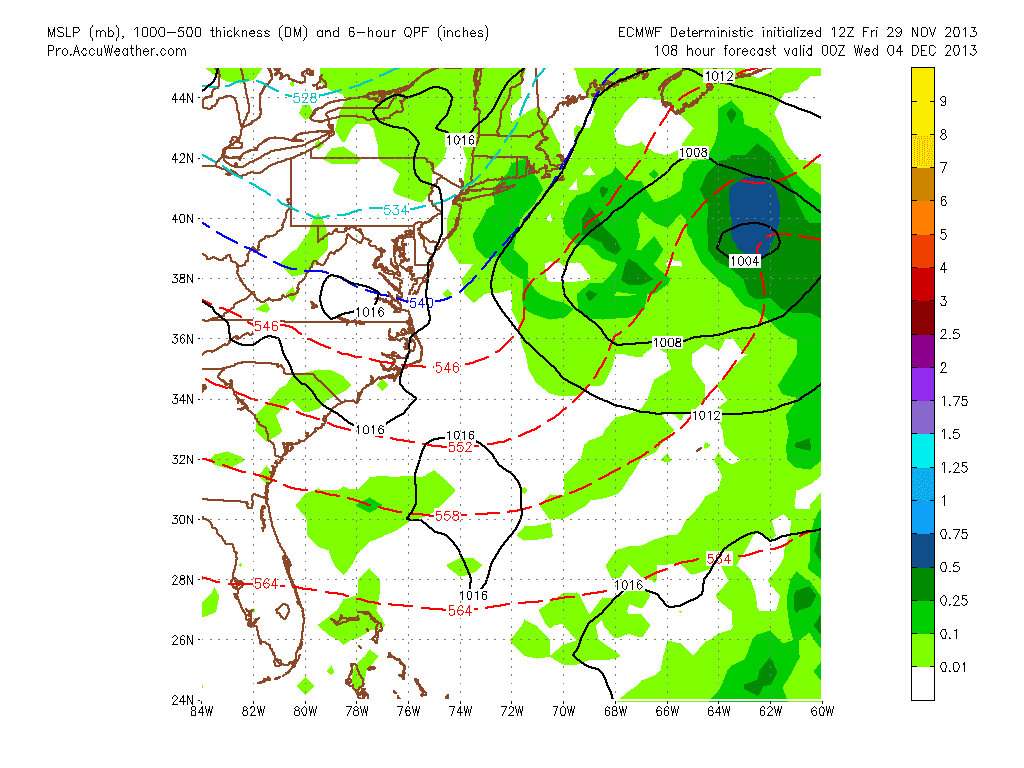
December will start off relative cold and stormy this year but quickly snap into a more mild weather pattern. I think a storm will develop early and effect areas east of the Mississippi. 

January:

Cold weather will arrive once January is underway and I believe we will see our first big storm of the season during this time frame most likely before mid month.

February:

February should be the most active month this year with overall cold and storminess centered on our forecast area. It is at this time I expect the strongest -NAO. and any potential slow start to my winter forecast to be made up for. 

Risks and overall forecast confidence to my forecast:

Biggest risks to a forecast bust this year will be a lack of blocking developing over Greenland and the Arctic due to recent solar activity strengthening the polar vortex and a QBO that does not drift towards a neural phase. Based on these two wildcard variables I give this forecast a 3 on a scale of 1-5 in confidence. 

Hope you enjoyed reading my insight on this winter. I will cut a video as well this week to verbally discuss this outlook.

@weatherwilly 


Saturday, November 9, 2013

Sat Morning Brief Summary

Good Morning. Quick post this morning but more detail to come on upcoming pattern on Sunday night along with my final Winter 2014 forecast. The storm will stay off shore next week as the trough over the east coast never amplifies enough. It was a fun storm to follow on the models but that's all it will end up being. From the beginning it was a very low probability scenario but I wanted to show the projected snowfall maps just for fun because you normal never see that this time of year. Unlike the weather channel, I never was making ridiculous predictions. 

The big theme next week will be a short but intense cold shot coming in from an arctic front. Temps will go into the 30's as highs towards latter part of the week, then pattern will warm up again to tail end of November.

More on this and the 2014 Winter outlook Sunday night. Be sure to check in. 

Friday, November 8, 2013

Afternoon Update: Out to Sea as Expected

Above is the latest European model pushing storm out to sea as other models have indicated. I mentioned this morning how I thought the European looked wrong based on its bias and it looks like that will be the case. However, it still has a deeper storm out to sea than every other model so its worth waiting till tomorrow to put the nail in the coffin.

I'll update with anything relevant by tomorrow morning. 

My winter forecast will be out Sunday night now for 2014, delayed because of attention paid to this storm. 

Friday Morning Storm Threat Update

Good morning. We now have a very large divergence between the European weather model that try's to blow up a monster storm giving the Mid Atlantic over a foot of snow next week and the other models which have all now backed off on the storm. Here is what we are looking at.

European: 975mb low blizzard conditions


 European Snowfall: 12-14 inches


Before people get too concerned here is GFS: A non event


A non event in this solution. Other models are along with the GFS but maybe slightly more to the west. This may be a case were the European is actually getting beat out by the other models, and the reason I say that is because its ensemble prediction system also is further east with this storm, which tells me that the model has a large margin of error at this point in time. Also, the flaw of the European is it likes to over bundle energy just as the GFS problem is it likes to sheer out energy out to sea. Since we have such a wide margin of outputs by both models, even taking an average will give us a non event, and we just end up with some very cold air. 

So whats the conclusion. I think for one this afternoons run of the European model will tell the tale. If it goes along with other guidance and shifts way east, I can confidently say we can throw in the towel on this storm threat. If however it remains firm with an idea of an historical storm effecting the east coast then we have to wait till at least the weekend to make a final call. Right now I am gaining confidence that this will not be a major storm for our area as the GFS is showing.

I will update later this afternoon after new models runs. Thanks for checking in. 


Thursday, November 7, 2013

First Look at Potential East Coast Storm

We have a very intriguing weather scenario that the models have been suggesting will set up for the latter part of next week. Before I get into any details I want to say we are still 7 days away which makes my projections far from a forecast at this point. The modeling first hinted at this two days ago on the European and now that most major models are in agreement on some storm forming, so I will break down the details. Most likely by Saturday I will start to take a stand on what I think will end up occurring. Until then lets look at whats projected to happen..


Above is an image I modified from the upper air pattern of the European model. Blue is low pressure areas and jet stream troughs (where storms like to develop) and orange and red are jet stream ridges (indicates high pressure, no storms.) This model is showing a very deep storm developing over the east coast as shown by green. The key however is understand why this storm develops so deep as shown. The factors involved are labeled on this map.


  1. Massive ridge over the Bering Sea causes a sharp trough underneath just off the west coast.The deep trough off the west coast then causes a massive ridge to develop over the central part of the country as shown above. Downstream this results in a sharp east coast trough. A rule of thumb is a trough just off the west coast usually results in a trough over the east
  2. Energy from northern Canada then travels around this central ridge as shown with the curving yellow arrow above and redevelops along the east coast bombing out a major storm.
  3. As this starts to develop that big central ridge then migrates to the east blocking the storm as shown below causing it to reach peak intensity over our area.


A setup like this is not very common which is why this forecast will be tough. Any slight change in the position of any of those variables I mentioned above changes the track of this storm. So now lets look at the model spreads at the surface. Top is European,  bottom is GFS


As usual there is a model spread and the GFS is showing its bias of shooting storms out to sea. At this point however both solutions are equally possible. Last night both the GFS and European gave the whole mid Atlantic over 10 inches of snow and since they they have spread out. Take the above European solution and move it in between this model spread and you have one ugly early season mid Atlantic snowstorm. As I said I am not ready to make a call on this yet, but with the water being so warm this time of year out in the Atlantic, the middle scenario needs to be considered. 

Just for fun, here is what last nights European model printed out for snowfall (click to make bigger)...


What I am confident in is that this setup will produce very bitter cold air for this time of year late next week regardless if this storm effects the Northeast. So bitter in fact that it might bust my November temperature forecast. In any event with have a big weather item that is now worth watching over the next 7 days I will be updating this blog daily with new developments. In the meantime follow me on twitter https://twitter.com/weatherwilly for more frequent updates on this situation. 


Saturday, November 2, 2013

Monday Night: November Pattern Update

Two weeks back I put out this map for November temperature projections..


Based on latest modeling I think this forecast will be accurate. The cold air we have had over the last two days will not last and will clear out by mid week as a very strong upper level ridge develops over the east coast


This will occur in response to a storm system that will be in the middle section of the country. Areas around I-80 will get snow from this system. Although there will be brief shots of cold this warm air will dominate though most of the month with that eastern ridge holding strong. Most of this warmth will be due to a positive North Atlantic Oscillation and Arctic Oscillation as shown in the green areas of low pressure over Greenland. As many of your know who follow this blog that is not a driver of cold weather for our area. 

Another factor to look at is an oscillation called the MJO which is an area of convection in the tropics that has an influence on the jet stream. Based on where this convection moves (1 of 8 phases) dictates precipitation and temperature trends over the US. Right now european model forecasts this oscillation will go from phase 1 into a weak phase 2 by November 18th as shown by green line

Below are temps for each phase..


As you can see the current phase favors warmer conditions over the east and phase 2 favors colder conditions, however it looks like we will be in a very weak phase 2 so the impact will be minimal. This leads me to believe the forecast of slightly warmer than normal (around 58 is normal temp for this time of year) in November will hold. The climate models agree..


I am going to be posting my final Winter 2014 forecast on Friday which will be broken down month by month and there might be some big changes form my preliminary forecast released in Sept. so be sure to check in.