Sunday, March 31, 2013
Wednesday, March 27, 2013
When Spring Temps Will Arrive and Winters Last Gasp
Good evening. As you can see I have transitioned this website to spring mode. I have not determined what the format of posts will be yet, so I will begin to play around with a few ideas such as a weekly video discussing the weather for the weak ahead, long term temperature trends, hurricane development and of course thunderstorm outlooks. But I am not at that point yet. For now I will keep the post format the same.
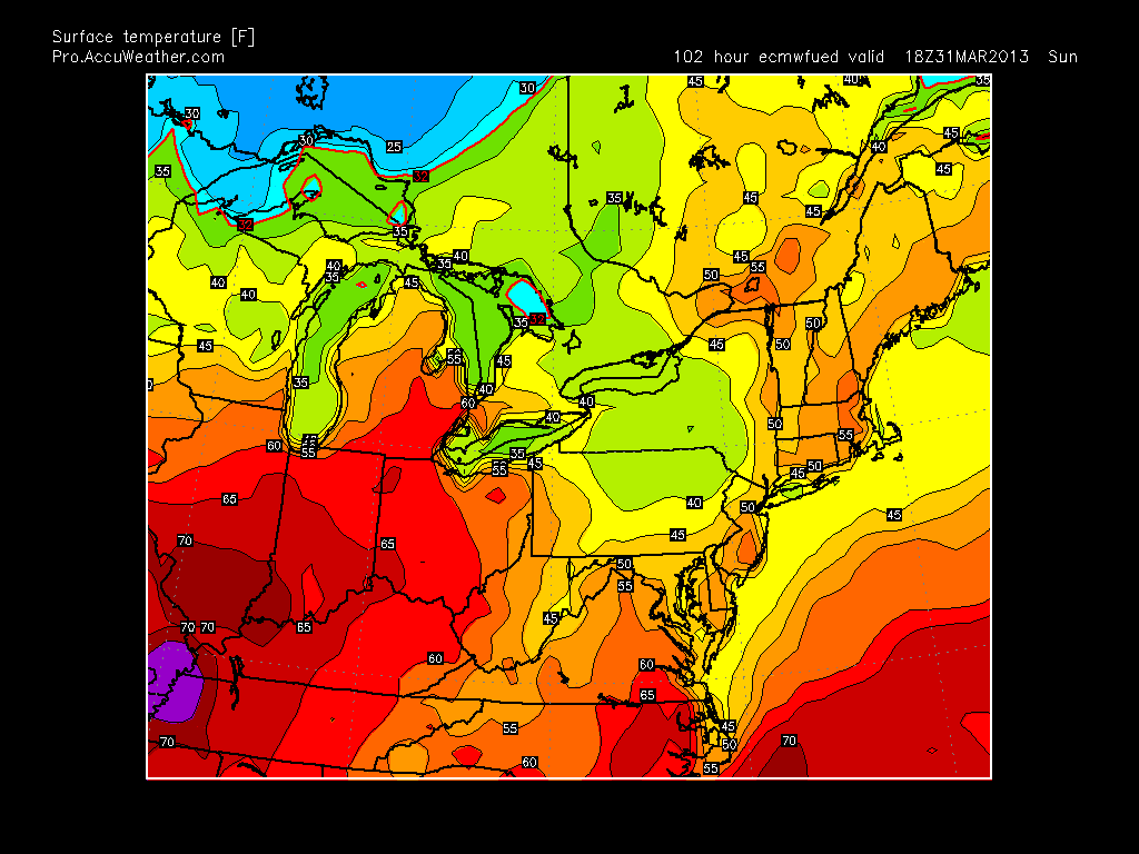
Looking ahead into the next three weeks, we will see slightly below average temps overall, with chances at precipitation early and late next week. I think next week will be the winters last attempt to give the country winter style storm setups mainly in the interior northeast. For Easter Sunday the weather should be beautiful with temps in the mid to high 50's.

In the wake of Easter, a storm system will develop and spread a cold rain through our region on Monday, with some snow up in VT and NH. After this unsettled weather, all eyes will be on a possible costal storm for that Friday. This is our last shot at a storm that in theory could produce snow for our area (do not bet on it at this point). Here is what we are looking at...

Looking ahead into the next three weeks, we will see slightly below average temps overall, with chances at precipitation early and late next week. I think next week will be the winters last attempt to give the country winter style storm setups mainly in the interior northeast. For Easter Sunday the weather should be beautiful with temps in the mid to high 50's.
In the wake of Easter, a storm system will develop and spread a cold rain through our region on Monday, with some snow up in VT and NH. After this unsettled weather, all eyes will be on a possible costal storm for that Friday. This is our last shot at a storm that in theory could produce snow for our area (do not bet on it at this point). Here is what we are looking at...

There are two separate disturbances that want to develop...one coming from central Canada and another in the gulf (circled areas). Depending on the speed and timing of these low pressure areas they have the potential to merge along the east coast. Given the strong ridge projected in the west (positive PNA) and the high pressure to the north in Greenland (negative NAO) this usually results in storms coming up the east coast. I have marked all these areas on the map above. Also, if you look just off the coast of California you can see a deep tough (blue and green colors) usually if you have a deep trough like that off the west coast the same occurs just off the east coast. The model however is showing the east coast through not as intense (no green mixed in with the blue). I think with time either both will be weak or both will be strong. The latter would produce a big storm. We are 10 days out and one or all of these factors can change and result in no storm or a bigger storm than what is shown. Snow would not be out of the question with the more extreme solution. I will keep you updated on this..
So when is spring coming? I think after next weekend spring will be here. There is evidence that temps will snap into the 60's and possibly 70's for the week of April 7th due to a strong high pressure system sliding down into the center of our country.
In summary:
1. Nice Easter weekend
2. Rain on Monday
3. Possible big storm on the following Friday (snow not out of question)
4. Week of April 7th spring temps will arrive.
Thanks for checking in.
Tuesday, March 26, 2013
Monday, March 25, 2013
Bust For Northern Zones
Its official...precip not heavy enough to pull down enough cold air so any snow will not stick today north of I-78. My forecast for these regions was wrong (not afraid to admit that).
In reality I could have backed down on this yesterday, but I choose to stick with it. To many by reading local forecasts there was a big contrast from what I was saying. Keep in mind there are many times when the pendulum swings the other way as well (more times than not). That was the case for the big storm in early Feb and many of the other events I predicted. When it is all said and done the southern part of my snow map will be fine, but not north of I-78. . I will give myself credit for calling this to effect the mid Atlantic a week prior..it just did not shift as far north as I expected.
I will post tomorrow what the final totals are..Snow will wind down this evening.
Monday Morning...I like what I have, Northern Zones Like I said Close Call
Good Morning..overall the storm is on track. I will give fair warning for bust potential in our northern zones. My forecast is not perfect, I will be the first to admit it. I think when this is all said and done our central and southern zones fall correct with my posted amounts but to the north we will be on the lighter side. I will note however, that the actual precipitation shield is a litter further north than what the model has by about 30 miles. This can make things interesting as things unfold today. lets take a look at some radar images...


Above is the storm currently. You can see the heavy precip in south jersey. This is mostly all snow and has started to accumulate in these areas. North of I-78 a flake has not fallen yet. This is expected and by this afternoon the radar should look like this...

As you can see the north part of our area is right on the fringe, and the central and south are getting hammered by heavy snow. So although it will snow everywhere that I am sure of, the accumulations to the north are going to come down to the wire. Yes, I know the national weather service has only had us in the 1-3 inch amounts in north jersey since yesterday and my amounts are higher. However, lets not forget I posted my initial map for all regions on Friday long before anyone else. So although I will be wrong in some areas, I hope people who read this will appreciate the stance I took days in advance on this system. Lets see how this plays out today and if we get thrown any surprises. I will update again around lunch time...thanks for checking in.
Sunday, March 24, 2013
Evening Video Update..Summarizing My Thoughts on Storm
This will be a very interesting storm to track tomorrow. The video above summarizes my thoughts. Someone will get a high total (excess of 6in) with this system. If you like snow there will also be some disappointments as well due to the fact there will be a sharp cut off in precip on the northern edge of this system. Right now nobody knows exactly where that northern edge will set up. We are talking a difference of 25 miles. In any regard the surface storm out in the Atlantic tomorrow will be very strong so the potential is still there. Enjoy video.
I will update again very late tonight with any additional thoughts.
Updated Snowfall Map
Here is my latest snowfall map for tomorrow. I made a few adjustments from my original, but overall the ideas are similar. I will cut the video tonight (before 9pm) due to some work I need to get done..I highly recommend watching tonight's video for rush hour conditions for the morning and evening commute. The NWS is not on top of this storm like they should be and most people are not even aware of it.


In depth details tonight..this will be an impressive spring snowstorm of which we have not seen for close to 15 years.
Big Late Season Snow On Way for Parts of Forecast Area
Video update will be up earlier this afternoon. By big late season snows I mean some places could see in excess of 6in..lets remember its spring not the middle of january. Check in for full details in a few hours...
Saturday, March 23, 2013
Video Update on Monday Storm: A lot of Uncertainty But Im Making a Forecast
Very tough call on this storm, but this is my prediction. If I need to change anything it will be tomorrow. I will update again tonight then cut one more video tomorrow with final forecast.
>>>>>>>>>>>>>>>>>>>>>>>>>>>>>
Afternoon NAM Model Update:

Not my prediction, I think this shifts north and west by tomorrow mornings runs for all models. NAM hanging in there tho with the stronger storm compared to other models..
GFS and Navy Model further north as well on last runs...more tomorrow morning
Friday, March 22, 2013
Snowfall Map for Monday Storm
Below is my prediction for snowfall amounts for Mondays storm. I am making a bold move here and taking a stance on this storm. I think the sweet spot of snow will be northern NJ where the surface temps will be the lowest. I also believe that the models will converge on a more northward solution by Sunday. As it stands the trend has started but it has a little bit to go. The Japanese and Canadian models are in my camp, but with slightly higher snowfall amounts. The european and gfs are a little less..

South of I-95 the sun is too strong, thus surface temps will be too warm for significant accumulations. If I need to change this map it will be late tomorrow or early Sunday. Lets see how this plays out.
Check in tomorrow morning before noon for a detailed video update...

South of I-95 the sun is too strong, thus surface temps will be too warm for significant accumulations. If I need to change this map it will be late tomorrow or early Sunday. Lets see how this plays out.
Check in tomorrow morning before noon for a detailed video update...
East Coast Storm Now Imminient
Models continue to trend to my ideas below including the euro which is shifting north. I will post snowfall map later tonight..
Friday Morning: Forecast for Storm Monday (Subject to Change)
Good morning, as I said I would release my first prediction today for the storm on Sat. Keep in mind alot can still change on the modeling, but I have enough data to make a prediction. All week I have shown the different model solutions, some being south, some being more north, and I mentioned how I believe they would correct north with time. Since then they have, but some are still more north than others. Models such as the Canadian, Japanese, and now the North American Model give the northern parts of our forecast area a heavy spring snowstorm on the order or 6-12 inches. Some of the more reliable models give us less and would result in a light to possibly moderate event. Despite the fact the European model is by no question the best forecasting model available, it has over time shifted north this week which some of the less reliable models have insisted on all week. The same goes with the GFS. They both still only bring light snow to our area, but the trend I need to see is there...so here is my initial prediction of what will happen on Monday..a snowfall map will follow tomorrow..
Lets start off with the map I posted yesterday as a baseline...

I still like this as a proxy for who has best chance at accumulating snow over 2in.
Snow will spread into our region late Sunday night/early Monday morning picking up in intensity as the morning rolls on. Southern zone will see some rain to start as the surface will be too warm to support snow, but snow should mix in as well. For our northern counties north and west of I-95 all snow will fall. The higher accumulations should occur in this area as well. I do not expect much accumulation south of I-95 as the sun will warm the surface too much in those areas. The storm winds down by Monday evening. To speculate, and this is not yet my official accumulation prediction I would suggest that the northern counties see on the order of 4-8 inches from this event.
Keep checking in for updates on this system...at this point things can move to any extreme (more snow or less snow) by the time Monday rolls around.
More Tonight.
Lets start off with the map I posted yesterday as a baseline...
I still like this as a proxy for who has best chance at accumulating snow over 2in.
Snow will spread into our region late Sunday night/early Monday morning picking up in intensity as the morning rolls on. Southern zone will see some rain to start as the surface will be too warm to support snow, but snow should mix in as well. For our northern counties north and west of I-95 all snow will fall. The higher accumulations should occur in this area as well. I do not expect much accumulation south of I-95 as the sun will warm the surface too much in those areas. The storm winds down by Monday evening. To speculate, and this is not yet my official accumulation prediction I would suggest that the northern counties see on the order of 4-8 inches from this event.
Keep checking in for updates on this system...at this point things can move to any extreme (more snow or less snow) by the time Monday rolls around.
More Tonight.
Thursday, March 21, 2013
No Changes for Now..Detailed Update Tomorrow Morning
My ideas today outlined have not changed much. I want to wait for tonights model runs before I give more details on this next storm...
Here is map I issued this morning as a first look


Here is map I issued this morning as a first look
This would be worst case scenario as shown by Canadian (most likely overdone)

Read posts below..more tomorrow morning
3pm Quick Update
Read this mornings post. The latest afternoon model runs have come in line with my idea of a blend between all models shown. The new Canadian is stronger, new gfs shifted stronger, new euro is stronger, new Japanese is the same, and new British model stronger. The end result is the map I drew this morning..lets see how this trend continues and if the Canadian model is onto something...
More later
More later
Thursday Am: Model Battle For Next Week's Storm
Good morning, there remains many question marks for next weeks storm system. Some models have a big mid Atlantic storm, while others remain consistent on the idea that the storm will stay more south. What bothers me is the highest skill model, the European has been consistent with a track more to the south with this system. The Canadian and Japanese models both have a powerful snowstorm, while the GFS has a compromise in the middle. In a situation like this, I like to look at what errors the models have had with storms this year up to date and attempt to make my prediction based on how I think the models will correct. Right now I am leaning towards a blend of 35% the European 20% the GFS, 20% the Canadian, 15% the Japanese, and 10% the British model. This would result in a moderate snow event for the mid Atlantic states giving many areas some accumulating snow. It would not result in a powerful snowstorm. I think the European will correct north with time and the more progressive models will ease more towards the mean solution. So real quick here is what each model is showing...
Euro..


Euro..

GFS

Canadian

Japanese..

As you can see this is not an easy forecast with such a spread in where this storm will set up along the coast. Here is my first take on who will be effected by this storm....
This is not my official prediction .I will mostly likely post that tomorrow and any snow accumulation map (if applicable) on Sat. For now I am going to stick with the idea that there will be a convergence to the middle of all these models solutions with a lean towards the north.
More Tonight.
Tuesday, March 19, 2013
Tuesday Night Video Discussion: First Look at Major Storm Potential for Next Week
The potential exists for a major storm (snow in many areas) to effect the east coast early next week. We are still 6-7 days away, but the maps look very impressive at this time. If this trend continues you will be the first to know. Keep checking in daily for updates on this evolving situation...
Monday, March 18, 2013
6pm Quick Update
Snow has spread into the whole region and will continue as snow for the next few hours in many spots. North and West should stay snow till aroind midnight then change to ice then possibly some rain. I want to clarify that areas in north jersey that I have on my map as rain means it will start as snow as it is now, but will not accumulate much if anything (areas near NYC).
I want to note that as I mentioned this morning this storm has potential to surprise to the upside w snowfall amounts. The low pressure system and cold high pressure to the north are slightly varied from where model said they should be at this time. I want to stick w my original perdition because I do not like to flip flop, but keep this in mind.
Tomorrow morning will be icy for areas north and west which includes western Morris county Sussex county and higher elevations of central morris county so be careful.
After this storm passes tomorrow my eyes are still on a potential major storm threat early next week..I will do an in depth analysis on its potential tomorrow night if it still looks promising.
Lets see how my prediction of snowfall totals plays out tonight..scroll down page for video and snowfall map posted over the weekend
Monday Morning Quick Update
I am still sticking with my snowfall map I posted on sat. (Scroll down page to see map). I outlined my ideas of how this storm will affect our region in last nights video as well so be sure to check it out.
I think if this storm throws us any surprises it will be to the upside w snowfall amounts. I have a general 1 to 3 across north jersey w 2 to 4 extreme north and west. I think across higher elevations In these areas a 6 inch amount is not out of the question, but I am going to stick w what I originally had.
All areas in north jersey will start as snow later this afternoon, then transition to ice then rain by midnight southeast to northwest. Please feel free to leave any comments w questions.
More later tonight..
Sunday, March 17, 2013
Saturday, March 16, 2013
Sunday PM: Snowfall Projections For Monday Night Into Tuesday
Below are my initial snowfall projections for the storm coming Monday evening into Tuesday. This will be a very complicated storm system, and sometime tomorrow afternoon I will cut a video to go into detail on exactly what to expect, but for now here is the map...


Friday, March 15, 2013
Update on Afternoon Model Runs
Good Evening. After analyzing the afternoon runs of the models, as usual Tuesday will be a very tricky forecast. At this point I think some snow can make it into our northern counties but it will not be snow the whole event. What is likely is light snow changing to rain then back to snow as the event progresses. What we will probably end up with is 1-3 inches locally in higher spots for our northwest counties. Rain will be prevalent elsewhere in the mid atlantic. Further north in interior New England I think 12-14in of snow is a good bet at this point. The areas of southeast new England will most likely see on the order of 3-6 inches depending on how close to the coast they are. Once This storm hits the pacific coast tomorrow I will post my first estimated snowfall totals for the whole region. The accumulations I mentioned in this post are just for discussion purposes.
Thursday, March 14, 2013
Thursday Night Discussion: Breaking Down Tuesday Storm and Winter's Endgame
Here is the current European snow map to go along with the video...this is not yet a prediction..

Thursday Morning: Active 7 Days Ahead
Good Morning...here is a quick brief summary of what I am looking at for next 7 days. There is going to be a lot of action in the Midwest and along the east coast starting with a weak system that will possibly spread some light snow in our northern counties Sat and sat night. I will go into more detail on this tonight but figure around an inch of accumulation in some spots.
The more interesting part of the forecast comes earlier next week where a powerful storm system will develop in the mid west and redevelop along the east coast. I think the best shot at a lot of snow is interior new England at this point from this system, but alot can change in the meantime. That area of my map I posted yesterday with the 50/50 shot at winter not being over is still in play for next weeks system. Tonight I will provide a detailed update on all this upcoming weather, and I will zone in on next weeks system with an initial prediction on who will get rain/snow on Sat. But for now, here is what could happen....this is not a prediction just an illustration of one particular model run...

The more interesting part of the forecast comes earlier next week where a powerful storm system will develop in the mid west and redevelop along the east coast. I think the best shot at a lot of snow is interior new England at this point from this system, but alot can change in the meantime. That area of my map I posted yesterday with the 50/50 shot at winter not being over is still in play for next weeks system. Tonight I will provide a detailed update on all this upcoming weather, and I will zone in on next weeks system with an initial prediction on who will get rain/snow on Sat. But for now, here is what could happen....this is not a prediction just an illustration of one particular model run...

More detailed info coming this evening...check in..
Tuesday, March 12, 2013
Tuesday Night Video: A Look At The Next 2-3 Weeks
The video takes a look at the next 2-3 weeks. Winter is not over for some areas and more storms are not out of the question. Here is a picture to summarize of what I will go into detail on in the video...

Tuesday Morning Summary
Good Morning. This week will be represented by rain coming thorough our region today and temperatures range bound between 32-45 degrees. Spring is in the air, but this pattern as I said still can produce snow (possibly a strong storm) in the next two weeks. Looks liek this weekend we can see a shot at some snow in the northern counties and then again possibly early next week. I have not seen the clear break in the pattern yet that would signal spring is here for good, and until I do I will keep an eye on potential events. Early next week would be the chance at a bigger storm it it will either effect the great lake region with snow and our area with rain, or if the storm develops more to the east it could spell trouble for us.
I will take a closer look at all of this tonight and cut a video...
I will take a closer look at all of this tonight and cut a video...
Monday, March 11, 2013
Friday, March 8, 2013
Friday PM: This Weather Pattern Does Not Want to Break
Before I get to the upcoming pattern next few weeks lets take a look at how i did with this last storm....
Official Snowfall:


Official Snowfall:

My Map:

Overall the perdiction turned out very well with the Baltmore DC Area. I did underestimate the whip around snows that hit north jersey today and instead of 2-5 it came out to be more like 4-8. The new england forecast was decent, but I missed some areas of CT getting hit harder. Overall I would give myself a B on this forecast. I will take credit for telling everyone DC and Baltmore it was way over hyped. Hope I helped some people stay ahead of the hype.
On a different note lets talk about the upcoming pattern for next two weeks. I am out west till monday night so I have not had much time to update blog, but that does not mean there is not weather to talk about. This pattern does not want to break! Our area will continue to see colder conditions though the next 2 weeks of march with a few spring days peppered in. There will be more shots at spring style snow events (similar to todays storm) and I am keeping an eye on a week for today for a possible development along the east coast.
The reason we will stay in an active winter pattern is because of the extreme amount of high pressure in canada that does not want to budge. This is keeping the cold air trapped the lower 48 (mainly east coast) and storms will continue to take a costal track due to this. Given the fact the warm spring air from the south wants to creep into the picture could create problems. By problems I mean cold air running into warm southern air producing a big storm. A pattern like this can produce a big endgame event before the full flip to spring is here. We saw set ups like this in the early 80's and 1993 where we had a few big mid to late march snow storms. Regardless if I am a snow lover or not, you cannot deny that this pattern is not over for at least 2 more weeks...lets see how it plays out.
I will update again later in the weekend and be back to doing daily posts on Tuesday when I am back home.
Thanks for checking in.
New post coming tonight at 9pm
I will summarize storm and take a look at the rest of march. A nice snow band set up over nj and NYC today and last night. Took accumulations into the higher end of what I expected (had 3-5). More tonight, sorry for limited posts I am out west traveling.
Thursday, March 7, 2013
Wednesday, March 6, 2013
Watch Last Nights Video...My Ideas Are on Track
Everything is playing out as I expected. The video from last night explains everything. I like my updated snowfall map. Lets see now how it plays out...
I can't Beleive the weather channel has such high amounts for north jersey and certain spots, they are way off key this time. Heavy snows will be limited to areas on my map.
Tomorrow night you will see wrap aroind snows effect the northern zones , that is when most of my posted accumulations will occur in that period.
Tuesday, March 5, 2013
Final Update On Tomorrow's Storm: Over Hyped In Big Cities
Watch video for update on tomorrows storm. The worst areas hit will be the mountains of WV and VA and Boston area. Big cities will not live up to the hype of this storm and I am calling for only a few inches in those spots except for grassy surfaces that can see a bit more.
Here was my original snowfall map..

And here is the updated map...

Not much changed in snowfall ideas for the lower mid Atlantic Only main change was snow up in Boston due to the storm hooking back in.
Enjoy the storm... brief update coming tomorrow
Not Many Changes
Good Morning. I am on the road so I will do a full video update later this afternoon. Overall, my forecast has not changed much since Sunday night. There will be some accumulating snow further north, but nothing more than a few inches in most spots with the exception of the higher elevations that can see a little more. I like the snowfall map for the Balt Washington area. I think 4-5 in will be a good range for the cities down there, with not much snow sticking to the roads until the tail end of the storm. Totals of 12 inches plus will occur in the mountains to the west of those cities as I originally thought.
Tonights new map will most likely add some accumulations to eastern new england as well. That could be the surprise of this storm, if the trend of it hooking back towards land continues. You will most likely also see accumulations on my new map ranging from 1-5 inches in NJ.
Check in around 5pm for final update.
Monday, March 4, 2013
Final update will come out tomorrow
I like my initial snowfall map from last night for the dc area. The most likely changes will be some accumulating snow extended into north jersey and eastern New England. Storm looks like it wants to hook back into New England after exiting the mid atlantic coast. This can extend 4 to 8 inches possibly to northern zones. Ill post a final map tomorrow.
Sunday, March 3, 2013
Sunday Night: Initial Projection of Snowfall For Wednesday Balt. to DC Storm
Watch video above for breakdown of the storm coming to the balt wash area on Wednesday. Below is my initial snowfall map for the event..I will tweak this on Tuesday before the storm with a final forecast. For those of us in North Jersey we will most likely miss this one, but the pattern will remain loaded throughout march. More on the pattern after this storm passes.

Sunday Morning: Storm Wednesday Looks to Have Baltimore DC in Crosshairs
I have enough information to now give an accurate forecast for Wednesday storm. I will post this forecast later this afternoon. In summary tho, storm right now looks to be a northern VA to MD special with snows that will exceed 1 foot in some areas. NJ and New England will not be effected by this storm.
Detailed breakdown coming later...
Detailed breakdown coming later...
Saturday, March 2, 2013
Sat Quick Breif
The storm for Wednesday has a long way to go. Models keep it south of our area, but as I have said we need to wait till tomorrow afternoon to get a better perspective. At that time I will make an initial perdiction. March will stay active till mid month.
Friday, March 1, 2013
A lot of Time for This Storm to Change
I will give another update tonight, but for now watch this mornings video. I think the local media outlets are hyping this storm next week up too much given the fact we still have alot of time in front of us. It will not be until the storm hits the pacific coast that the computers will get a better handle on what will happen. For now my forecast is just POTENTIAL for a storm I give it a 50/50 shot for our region.
Friday Morning: First Look at Storm Potential For Next Wed
This video goes through the first look at the storm threat for next Wed and Thurs. We still have a long way to go before this materialized so we will not really know until the weekend how severe storm can be. Right now there is the POTENTIAL but nothings in stone. Alot will change from now until Wed. I will take a closer look at this tonight. As I mentioned in my last post, all the players are on the feild till march 15th for a big storm. We gotta just wait now and see if my prediction will come true.
Subscribe to:
Posts (Atom)